jconsor
-
Posts
1,008 -
Joined
-
Last visited
Content Type
Profiles
Blogs
Forums
American Weather
Media Demo
Store
Gallery
Everything posted by jconsor
-
2021 Atlantic Hurricane season
jconsor replied to StormchaserChuck!'s topic in Tropical Headquarters
Long thread offering some thoughts on why the ITCZ and Caribbean activity have been suppressed up until now in Oct... Why some forecasters are convinced the season is over in the Atlantic: ...And how a significant change in the pattern is coming next two weeks that favors better chance of Caribbean activity: -
2021 Atlantic Hurricane season
jconsor replied to StormchaserChuck!'s topic in Tropical Headquarters
-
2021 Atlantic Hurricane season
jconsor replied to StormchaserChuck!'s topic in Tropical Headquarters
-
-
2021 Atlantic Hurricane season
jconsor replied to StormchaserChuck!'s topic in Tropical Headquarters
Nice post! There were a lot more October landfalls along the US East Coast from SC northward to New England from the late 1600s to the early 1800s than since 1850. I was able to find at least two that hit the East Coast in Oct and probably originated east of 55W, based on historical accounts: The 1804 "Snow hurricane" that caused severe damage from NJ to New England on Oct 9. Chenoweth who did a reanalysis of 1700-1850 cites this storm as having tracked north of Puerto Rico. https://en.wikipedia.org/wiki/1804_New_England_hurricane Further details on damage in the northeast US: https://myweb.fsu.edu/jelsner/temp/HHITProject/HHITyears/1804/1804.htm 1706 tropical storm that tracked from Barbados to NY, with damage from wind and rain reported in NY/CT on Oct 15. https://en.wikipedia.org/wiki/List_of_Atlantic_hurricanes_in_the_18th_century Chenoweth paper: https://www.aoml.noaa.gov/hrd/hurdat/Chenoweth/chenoweth06.pdf BTW and for entertainment purposes only, the 12z CFS is fixin' to break the record you mentioned. It shows a TS forming on Sep 27 just west of the CV islands and tracking west to a position just NE of the Leeward Islands Oct 2-3, then rounding an anomalously strong W Atl ridge before hitting eastern New England on Oct 7. -
2021 Atlantic Hurricane season
jconsor replied to StormchaserChuck!'s topic in Tropical Headquarters
Some insights into the lack of US landfalling hurricanes (along with no major hurricane landfalls) between 2006 and 2015, and the recent pronounced increase in US landfalling hurricanes. -
-
-
2021 Atlantic Hurricane season
jconsor replied to StormchaserChuck!'s topic in Tropical Headquarters
-
Interesting analysis on rainfall potential from Nicholas:
-
About Nicholas's wobbling... it is likely temporary.
-
2021 Atlantic Hurricane season
jconsor replied to StormchaserChuck!'s topic in Tropical Headquarters
-
2021 Atlantic Hurricane season
jconsor replied to StormchaserChuck!'s topic in Tropical Headquarters
-
@OSUmetstudI agree with the idea that Larry was most likely overestimated yesterday, considering the SFMR winds and dropsondes from recon. Larry likely got down to cat 1 at some point late yesterday into early today. IMHO there is a good chance it will become better organized and likely will be a cat 2 until just before Newfoundland landfall. See short thread below.
-
Thanks!
-
-
Thanks for the local perspective, Nick @OSUmetstud! Appreciate it very much. What's your Twitter handle? Mine is @yconsor. I've also been posting some updates on potential Newfoundland impacts from Larry there.
-
Tropical Storm Mindy Max Winds 45Mph
jconsor replied to SnowenOutThere's topic in Tropical Headquarters
Mindy could produce some surprises for NE FL and SE GA, including inland areas. -
Great updates Walt @wdrag - thank you! Just finished the Rosh Hashana holiday so I am just now catching up on this threat, which looks much more significant than two days ago before the holiday when I last looked. Check out this entire thread I posted - just posting some snippets to not overload forum:
- 50 replies
-
- 6
-

-

-

-
- flash flooding
- river flooding
- (and 1 more)
-
Tropical Storm Mindy Max Winds 45Mph
jconsor replied to SnowenOutThere's topic in Tropical Headquarters
Go Mindy! Shows you can never count out a tropical system and always need to keep watching, especially one this close to land and especially one in the bathwater of the Gulf of Mexico. Also goes to show satellite appearance of a developing TC doesn't always equate to the kind of winds it produces - Mindy has some deep convection but organization is lacking and it looks pretty dissheveled Yet Mindy is already producing sustained winds of 50 mph at a buoy slightly east of her center! -
2021 Atlantic Hurricane season
jconsor replied to StormchaserChuck!'s topic in Tropical Headquarters
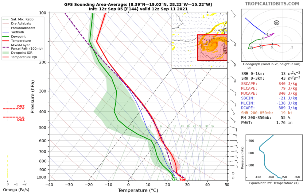
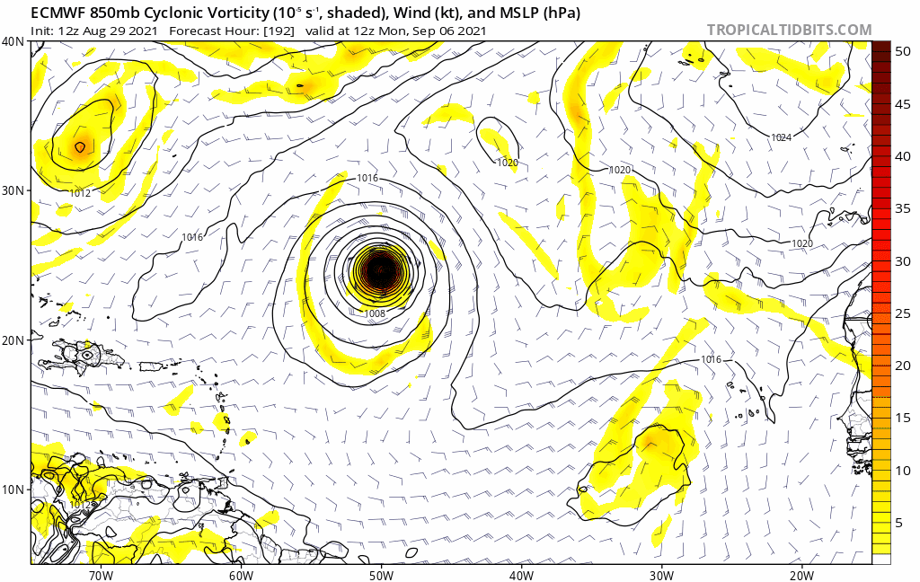
The plot thickens... there is clearly an upper trough/weakness in the subtropical E Atlantic that has been trending stronger past few days, but only a stronger system would really feel the effects of this. GFS has that trough as well and it's even deeper than the ECMWF, but a sounding clearly shows mainly easterly winds from 500 mb and below around the tropical wave as it comes off the African coast, with SE winds above 500 mb. (Note it comes off the coast about a day earlier then the ECMWF). The ECMWF/EPS have a known significant bias to show "landcanes" that are too strong inside W Africa and then coming off at an unreasonably high latitude. This bias was on display seen even with a relatively weaker wave like the one that is just moving off the African coast today. See how ECMWF trends about 350 mi SW with the center of vorticity vs. runs three or four days ago.