

beavis1729
-
Posts
2,554 -
Joined
-
Last visited
Content Type
Profiles
Blogs
Forums
American Weather
Media Demo
Store
Gallery
Everything posted by beavis1729
-
1/24-1/25 Major Winter Storm - S. IL, IN, and OH
beavis1729 replied to A-L-E-K's topic in Lakes/Ohio Valley
Yes sir…and why not, I’ll pile on. With a prog like this, one might think there’s room to go at least a bit further north.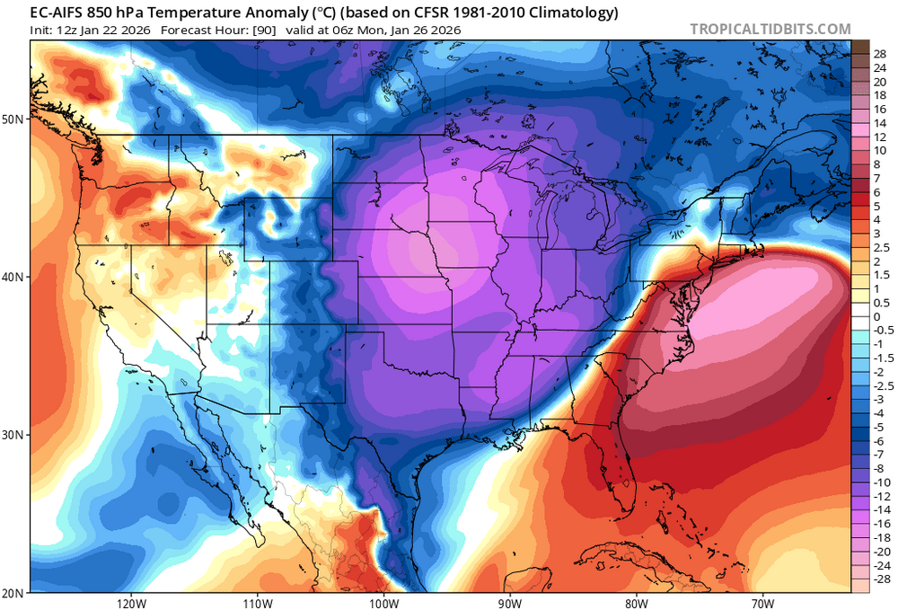
-
Here it comes...Bottineau ND is already down to -22 with NW winds at 23 mph, WC -53. It was -2 there at midnight, but will probably remain in the -20s for the rest of the day, even during peak heating. The ultimate "midnight high".
-
I could see -17 or -18 in GRR if everything goes right. Deep cold airmass, healthy snow cover, and minimal moderation from LM. So not quite the all-time record, but maybe the top 10 coldest on record?
-
Yeah, which is definitely unfortunate. The good news is there’s at least some snow cover, and there won’t be much modification of the airmass due to the upstream snowpack combined with the winds/advection. This will be one of those arctic outbreaks where the airmass is very impressive (which I define as -35C or colder at H85 somewhere in the lower 48), but the ground temps underperform relatively speaking. Still a decent arctic outbreak, but not what it could be. This is opposite of what occurred in January 2009, where the airmass wasn’t crazy cold but there were very low temps due to fresh deep snowpack and clear/calm conditions. Regardless, we may see the coldest temp here since January 2019.
-
Winter 2025-26 Medium/Long Range Discussion
beavis1729 replied to michsnowfreak's topic in Lakes/Ohio Valley
See the cold wave thread, if you want to post there for posterity. I’ll put some info in there soon. -
DLH Area Forecast Discussion National Weather Service Duluth MN 1248 PM CST Tue Jan 20 2026 .KEY MESSAGES... - Brutally cold temperatures are expected through the weekend, with multiple days below zero Thursday through Sunday. Low actual temperatures in the negative 30s to 40F, and minimum wind chills in the negative 30s to 50s. The coldest days will likely be Friday and Saturday. - A couple areas of light snow pass over the region this evening through the day Wednesday. Accumulations of an inch or less are expected. - Light lake effect snow and clouds may persist along the South Shore through the weekend. && .DISCUSSION... Issued at 1243 PM CST Tue Jan 20 2026 Relative to the last couple days and the coming days, today and tomorrow will be fairly "mild" (in a northern mid winter sense). High temperatures above zero are expected this afternoon and Wednesday - with some folks seeing afternoon temperatures in the teens tomorrow! This temperature moderation is occurring thanks to some WAA ahead of a couple passing upper level vort maxes spurring on some weak surface clippers. These will pass through this evening through Wednesday bringing a couple areas of light snow. The first passes through this evening, mostly from Brainerd to Hayward. The second should move across the area from northwest to southeast through the day Wednesday with a little wrap around snow lingering into Thursday morning. Total accumulations should be around an inch or less across the region. Behind the Wednesday clipper, a hefty cold air mass is expected to drop into the Northern Plains, Midwest, and Great Lakes region through the weekend with 850mb temperatures dropping into the -30s Celsius. This is expected to result in several days of some very cold surface temperatures beginning Wednesday evening through at least Sunday midday, when temperatures are unlikely to rise much above zero, if at all. The coldest days of this period are expected to be Friday and Saturday. Thursday and Friday, brisk northwest winds are expected which will lead to the coldest winds chills of this period Thursday night into Friday morning. Wind chill values of -40 to -50F are possible. The coldest actual air temperatures are expected Friday night into Saturday morning when widespread temperatures of -30 to -40F are forecast. There is a 5 to 10% chance that some of the local coldest spots could drop to -50F actual temperature on Saturday morning. With these cold temperatures and high confidence in them occurring, we`ve issued a plethora of cold weather headlines with this forecast update. For Wednesday evening into Thursday morning/midday, we`ve gone ahead and issued a Cold Weather Advisory for much of the area, with an Extreme Cold Warning along the far north. The Borderlands warning and the advisory along the Iron Range/North Shore continue through the day on Thursday as any diurnal warming is expected to be minimal. Thursday evening, the whole area falls into a Extreme Cold Watch through midday Saturday. Sunday and Monday mornings will likely feature more Cold Weather Advisories but shouldn`t be as brutally cold as Friday/Saturday. Looking ahead to next week it appears we`ll moderate slightly but still be below normal. There are little to no chances of snow after tomorrow`s clipper, outside of the South Shore possibly getting some on/off lake effect with the northwest winds and cold temperatures. Global models show a slight chance of snow returning mid next week as slightly warmer temperatures allow moisture back into the area.
-
NWS is forecasting 3 consecutive nights in the -30s at INL...and it will probably hit the -40s in the radiator spots of Tower and Embarrass if winds go calm. Wednesday A 40 percent chance of snow, mainly before noon. Mostly cloudy, with a high near 11. Light and variable wind becoming northwest 5 to 10 mph in the morning. Winds could gust as high as 20 mph. Wednesday Night Partly cloudy, with a low around -23. Wind chill values between -25 and -35. Northwest wind 5 to 10 mph, with gusts as high as 25 mph. Thursday Partly sunny and cold, with a high near -14. Northwest wind 5 to 10 mph, with gusts as high as 25 mph. Thursday Night Mostly cloudy, with a low around -30. Northwest wind 5 to 10 mph, with gusts as high as 20 mph. Friday Mostly sunny and cold, with a high near -14. West wind 5 to 10 mph, with gusts as high as 20 mph. Friday Night Partly cloudy, with a low around -38. West wind around 5 mph becoming calm in the evening. Saturday Mostly sunny and cold, with a high near -9. Calm wind becoming southwest around 5 mph. Saturday Night Partly cloudy, with a low around -30. Calm wind. Sunday Mostly sunny and cold, with a high near -2. Calm wind becoming west around 5 mph in the morning.
-
MKE URGENT - WEATHER MESSAGE National Weather Service Milwaukee/Sullivan WI 1240 PM CST Tue Jan 20 2026 WIZ046-047-051-052-056>060-062>072-210245- /O.NEW.KMKX.EC.A.0001.260123T0600Z-260124T1800Z/ Marquette-Green Lake-Fond du Lac-Sheboygan-Sauk-Columbia-Dodge- Washington-Ozaukee-Iowa-Dane-Jefferson-Waukesha-Milwaukee- Lafayette-Green-Rock-Walworth-Racine-Kenosha- Including the cities of Endeavor, Germantown, Benton, Markesan, Oxford, Shullsburg, Muskego, Cedarburg, Oostburg, Portage, Jefferson, Belmont, Waupun, Reedsburg, Columbus, Watertown, Waukesha, Berlin, Fond Du Lac, Dodgeville, Fort Atkinson, Madison, Beaver Dam, Princeton, Montello, Grafton, Argyle, Whitewater, Mequon, Barneveld, Baraboo, Darlington, Brookfield, Sheboygan Falls, Janesville, Beloit, Lake Geneva, Plymouth, Mayville, Menomonee Falls, Elkhorn, West Bend, Delavan, Lake Wisconsin, East Troy, Prairie Du Sac, Racine, Kenosha, Howards Grove, New Berlin, Sauk City, Monroe, Westfield, Milwaukee, Mineral Point, Lodi, Neshkoro, Hartford, Blanchardville, and Brodhead 1240 PM CST Tue Jan 20 2026 ...EXTREME COLD WATCH IN EFFECT FROM LATE THURSDAY NIGHT THROUGH SATURDAY MORNING... * WHAT...Dangerously cold wind chills as low as 40 below possible. * WHERE...Portions of east central, south central, and southeast Wisconsin. * WHEN...From late Thursday night through Saturday morning. * IMPACTS...The dangerously cold wind chills as low as 40 below zero could cause frostbite on exposed skin in as little as 10 minutes. PRECAUTIONARY/PREPAREDNESS ACTIONS... Dress in layers including a hat, face mask, and gloves if you must go outside.
-
January 2026 regional war/obs/disco thread
beavis1729 replied to Baroclinic Zone's topic in New England
Today's 12z Euro shows near -40C at H85 in NW Minnesota at 84 hours. That's the type of airmass that can produce -40F or colder surface temps in the typical radiator spots, like Tower and Embarrass, if skies clear and winds go calm or near calm. Probably the coldest airmass in that part of the world (and imby) since late January 2019? -
Nice summary. Does anyone know of a reliable current snow cover map for the Midwest? Dropped to -3F here this morning, up to 5F at noon.
-
Winter 2025-26 Medium/Long Range Discussion
beavis1729 replied to michsnowfreak's topic in Lakes/Ohio Valley
Nice -
Yeah…GEM at hour 132 shows temps of -20 in N IL, -30 around MSP, and -40 in ND. I know this model tends to overdo cold…but yikes.
-
2/2/1996 was the infamous -60F in Tower, MN.
-
I agree...but if it's any consolation, there's currently no snow cover at all in the Midwest south of 44.5N. I was just up in northern WI for my nephew's hockey tournament, and the snow cover wasn't really consistent until you hit Wausau (which is approx. 45N). And it's even worse further west in the Plains...I believe there's bare ground in most of ND, SD, and MT. Grand Forks ND typically has deep snow cover this time of year, but they only have 5" on the ground. Their max depth all season has only been 6". Very hard to believe for mid-January. Hopefully things change soon, even as I prefer that wintry weather occur at the beginning of the season due to the holidays and shorter day length.
-
Texas 2025 Discussion/Observations
beavis1729 replied to Stx_Thunder's topic in Central/Western States
Well, TX is a big state. January normals (roughly) are: Brownsville 73/53 San Antonio 64/40 Dallas 56/36 Amarillo 48/24 Either way, it has been much warmer than normal in TX and the entire plains/Rockies. This chinook pattern is driving me crazy. It’s the absolute worst winter pattern in the lower 48 for many reasons, and has persisted for 4+ weeks. When will it ever end? -
MO/KS/AR/OK 2025-2026 Winter Discussion
beavis1729 replied to stormdragonwx's topic in Central/Western States
Yeah. These winter chinook patterns are obnoxious, and it has been going on for 3-4 weeks now. MT, WY, CO, ND, NE, and SD have essentially had no winter so far…and these are not exactly tropical locations. Even in areas further east, it is an extremely boring pattern. And west of the Rockies, it’s warm too. So it’s a bad winter pattern for the entire lower 48, which is ridiculous to be occurring during the heart of winter. Even when chilly NW flow occurs east of the chinook, it’s horrendously dry because the typical GOM moisture source is cut off. And the ridge/chinook is always lurking, so it often becomes warm for a few days here when the ridge shifts east a bit, and melts any modest snowfall which may have occurred prior. What will shake this pattern up? Models occasionally show signs of it changing, but the chinook seems to try reestablishing itself all the time. It’s frustrating to see 30s and 40s in MT on the models, even at the coldest time of the day (12z). If I lived there, I would be going crazy this winter. At least Alaska is experiencing winter. Extreme cold inland, and very snowy in Juneau and nearby areas. -
I don’t think they are trolls; they just have higher standards (myself included). In my area, we had a great 10-day period from November 29-December 8, but we have not seen one flake of snow since then. And, no snow cover since December 10. This is in line with my earlier comments where the good periods can be fantastic here, but then things just seem to shut down completely for weeks at a time, especially in recent winters. I would prefer more stability and “decent” periods simply due to the calendar saying DJF, instead of all or nothing. Based on the fast start to winter, it was looking like a lock for a white Christmas, but ended up not being close at all. Most of it is frustration, combined with “show me the money”. To me and many others, cold without snow cover feels like a waste. That’s why people want to see chances of snow to accompany the upcoming cold. My post isn’t intended to come across as complaining; just trying to acknowledge the situation and also hope for the best!
-
December 2025 Short/Medium Range Forecast Thread
beavis1729 replied to John1122's topic in Tennessee Valley
Yikes, and good stuff…just a bit chilly. It’s strange to me that an algorithm could affect temperature outputs from a model. You’d think the model output is what it is, and then is simply displayed in map form. Maybe there is some interpolation that WxBell and other companies do, to “fill in” the data gaps? A discussion for another time, I suppose. Anyway - as an example of the ongoing cold in eastern AK and the Yukon, Juneau AK dropped to -10 yesterday. It hasn’t been colder than -10 in Juneau since 1974. -
December 2025 Short/Medium Range Forecast Thread
beavis1729 replied to John1122's topic in Tennessee Valley
Yeah...hovering over the pixels in the Yukon on the map below, there's a modeled -71F at hour 312. I keep an eye on modeled temps up there in the winter, and seeing anything colder than -65F on the GFS (since it's a global model and therefore doesn't capture the local terrain/cold spots very well) is extremely rare. While I agree it could be driven by model feedback, it's still very impressive to see. As for ground truth...I believe the coldest temp in Alaska since 2000 is -64F in early Feb. 2024. So, if these modeled temps come close to verifying, I'd argue it would be the coldest temps in 25+ years in that part of the world. Great article on Alaska's 2024 cold outbreak here: https://alaskaclimate.substack.com/p/alaskas-2024-cold-snap Also, for anyone interested in Alaska weather & climate, this is a great blog: https://ak-wx.blogspot.com/ -
December 2025 Short/Medium Range Forecast Thread
beavis1729 replied to John1122's topic in Tennessee Valley
That January 1989 Alaska cold snap, in my opinion, could be a candidate for the most impressive temperature-related weather event in recorded history on Earth, relative to “normal”. Tanana, AK was the epicenter. During the last 2 weeks of that month, every single day was at least 43 degrees colder than normal. The peak of the cold was 1/27/1989, with a high/low of -60/-76…which is 60 degrees colder than normal. An absolutely unbelievable event. While Alaska has had some impressive cold waves since then (Dec. 2012 comes to mind), they have mainly been duration-driven instead of extreme intensity. Nothing has come close to the severity of January 1989. -
December 2025 Short/Medium Range Forecast Thread
beavis1729 replied to John1122's topic in Tennessee Valley
Nice find, and I see it listed as an option on Pivotal Weather too. -
Winter 2025-26 Medium/Long Range Discussion
beavis1729 replied to michsnowfreak's topic in Lakes/Ohio Valley
And Midlo VA Snowmaker, who often posted in the mid-Atlantic forum. -
December 2025 Short/Medium Range Forecast Thread
beavis1729 replied to John1122's topic in Tennessee Valley
Speaking for myself on the chinook discussion, I didn’t intend to imply that it would directly affect us with warmth for a long period of time. The problem, in my mind, is the existence of the chinook pattern itself, even though it has really only caused warmth in MT, CO, WY, NE, SD. This has been going on for several weeks. Places like Denver, Cheyenne, and Rapid City have essentially had no winter so far, and unfortunately that looks to continue for the rest of the month. Joe Bastardi, or perhaps a different met, has a saying about “the angle of the cold”. In a chinook pattern, the angle of the cold is wrong for us, for two reasons. First, even when it does stay cold here, it’s very dry and boring due to NW flow. Second, the warmth is always lurking, because we’re on the far western edge of the cold airmass. So, any minor change in the flow quickly makes it warmer here. That happened last week in my neck of the woods, where a couple of good early season snowfalls melted away because the warmth out west pivoted over here…even though it only lasted for a few days. The point of all this is that, to me, it’s a much better pattern for all of us when there is no chinook at all. I like to see highs come down into the western plains, creating upslope snow in MT/WY/CO, then the cold eventually trickles east and lasts for awhile. Basically, I’m describing a -EPO from a more “on the ground” perspective. I just think the current pattern (starting around 12/5) has been very obnoxious, and unfortunately it looks to continue for 10 more days. Definitely good to see some light at the end of the tunnel, and it can’t come soon enough. -
December 2025 Short/Medium Range Forecast Thread
beavis1729 replied to John1122's topic in Tennessee Valley
Yeah, that was a crazy period. Chicago was 69F on 12/28/1984, then a few weeks later it hit -27F on 1/20/1985 during one of the greatest arctic outbreaks in modern history. -
December 2025 Short/Medium Range Forecast Thread
beavis1729 replied to John1122's topic in Tennessee Valley
All good, and I definitely hear you. Speaking for myself (and possibly many others on the board), I don’t think people are saying that winter is over. People are just sad that winter is taking a break. For those who love winter like myself, we want it to look and feel like winter throughout DJF. Most people like warm weather, and I don’t mind it either…and that’s fine during the other 9 months of the year. I just want DJF to be sacred, especially December due to the short days and holidays…and mild temps during these months (even for a day or two) are annoying to me. I always say it’s more about the look and feel and tenor of the season, as opposed to just chasing a big storm. In some ways, it’s analogous to being a sports fan. You want your team to win every game, even though it’s not realistic. When you love something, emotion is more meaningful than logic. And I definitely get the logic piece, since I have a met degree. My career ended up going in a different direction, but it’s still one of my favorite hobbies, mainly driven by the beauty of winter.


