

Windspeed
-
Posts
4,816 -
Joined
-
Last visited
Content Type
Profiles
Blogs
Forums
American Weather
Media Demo
Store
Gallery
Everything posted by Windspeed
-
**Warning: Loud volume with explicit language** I saw this video on another site that mentioned near Etowah. Save your ears and adjust volume down prior to viewing.
-
SPC is definitely leaving the door open for a possible upgrade as well: "Given the potential for significant severe storms, a categorical upgrade is possible in later outlooks once predictability increases and the centroid of severe coverage is better established."
-
The Lawrenceburg footage is very intense. Perhaps the most violent tornado ever recorded in Tennessee on video. Though the 20 mile path traversed sparsely populated communities, still quite miraculous that it resulted in no deaths.
-
Day of the EF-4 Henryville, Ind. tornado: ..and that same day near Chattanooga, an EF-3 hit Ooltewah and Cleveland, Tenn., and also this EF-2 in Etowah:
-
Those super cells earlier produced some minor wind damage reports but nothing tornadic fortunately. Probably haven't seen the last FFWs tonight though. Some serious heavy rainfall in these cells over NE AL and NW GA.
-
Some organizing supercells moving towards north-central Alabama. Weak rotation but nothing yet tornadic.
-
 Gita is a gorgeous cyclone. The status is currently at Category 4. Though it temporarily reached Category 5 yesterday, it has maintained a fairly steady large eye and taken on some annular characteristics. A reminder that categories in the S. Pacific and Australia are not the same as the N. Pacific and N. Atlantic.
 -
Historic Tennessee Valley Cold, Snow, and Ice Events
Windspeed replied to Carvers Gap's topic in Tennessee Valley
Did it not snow fairly significantly in the eastern Valley following weekend after the March 12-13th event as well? I believe we were around 14" officially at KTRI for the Blizzard of '93 event, though closer to 18" on average at our house. But later that next week I seem to recall an additional 3-6" off a seperate clipper. Edit: Nope, I'm getting the '96 blizzard mixed up with the '93 blizzard. Also, looking at the intervals of time between major blizzards during my childhood and teenage years is depressing. -
Severe Cylcone Gita is churning away in the S. Pacific near Tonga. It is still classified a Cat 4 based on latest advisory, though, based on over-night imagery, it may have weakened temporarily or gone through an ERC. That process appears to have completed as the eye is again clearing out. The core will cross through a favorable environment and higher SSTs the next 24-48 hours. As such, Gita may not yet have reached its maximum intensity. The core will pass very close if not over the island of Ono-i-Lau very close to or at Cat 5 intensity.
-
https://africatimes.com/2018/01/05/madagascar-prepares-for-tropical-storm-ava-impacts/
-
I like this system to undergo a period rapid intensification over the next 24-36 hrs into landfall. I think this makes landfall stronger than 80kts. Perhaps even reaches Category 3. The core is getting established and the upper environment is clearly favorable. 27-28°C SSTs should support sufficient enough instability given the divergence aloft and jetstreak to the north.
-
115 kts ... massive wind radiii: Near or at landfall:
-
They can handle a Cat 2/3, yes, they have sea walls and well built structures. But that's besides the point. Even a Cat 2, don't take it seriously and it hits a densely populated area, see what happens. And just based on current motion, 15-20kt of weakening is probably close to the mark. It wouldn't be good and it will cause destruction. Nobody was hyping this. Edit: Current intensity is 125 kts and that may even be high. Earlier, when Lan looked a lot better, mind you, I made the 15-20 kt comment based on its appearance versus rapid forward motion. It's down to 125 kts. So give me the benefit of the doubt of 20 kts. You win. It will clearly weaken more than 20 kts. Probably 30 kts by landfall. Congratulations. I apologize for overhyping a 135 kt typhoon based on a worry of rapid motion. A Cat 2/3 landfall was forecast throughout and that is likely what it will be. Never called for anything higher, but you are correct. I insinuated hype with the word "worry" that it wouldn't weaken below Cat 3. It most likely will. Cheers!
-
That is your definition of hype? The core is in rapid motion. It's a worry vs I should just call it a windy day and move on?
-
Please quote me hyping this typhoon. Quote any words. I beg you. You are ridiculous.
-
I just do not see what your point is here. Who has made a call this will landfall as a Super Typhoon? Look at the forecast. It's still serious for Japan.
-
Also, NOBODY in this thread has been overhyping Lan. Not in the least. Get real.
-
Good thing that's not how we alert the public. You don't downplay a 135kt cyclone. Yes, the core may degrade to absolute crap by landfall. You want to base your advisory on that call. Have you ever been in a Cat 2/3 storm? This will be destructive. Hopefully it will weaken and that destruction will be mitigated.
-
Haha. That's clearly your opinion. I see this as a powerful system that is going to make landfalll in a densely populated region. All based on perspective I suppose.
-
Perhaps in 8-10 hrs, but the perspective that it's falling apart based on current satellite presentation isn't good sound meteorology. We all knew the system was going to weaken based on the environement. But Lan isn't exactly hot garbage.
-
Define "really going downhill"? If convection were falling apart, I'd concede. But this is classic tilting due to mid-level flow. Only, at present, the core is moving rapidly enough to counter it. That northern eyewall must still be quite fierce with such intense convection wrapped around it. Yes, you will have an assymmetrical appearance outside the core with baroclinic influence and increased southwesterly flow, but the core itself around the eyewall remains symmetrical and intact. This is still an intense typhoon. Hopefully it will begin to weaken significantly for the sake of impact on a highly populated region.
-
The center may be slightly tilted as well. Southerly flow is screaming. This is still an intense typhoon though. I am a bit worried this won't weaken more than 15-20 kts prior to landfall ue to rapid forward motion.
-
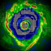
It's nice to have some recon surface obs for once in the WPAC to back up satellite estimates. I will say that Lan looks even better than it did when they acquired their dropsonde data yesterday. EDIT: ADT ranged from 5.9 to 6.3 during the time they would have been in the eyewall. At present, ADT CI # is: 6.8 / 922.9mb/134.8kt JTWC 21/2100 discussion:
-
I wonder if Lan will be intercepted by reconnaissance aircraft. Last year, there were several publications that members from Nagoya University and the Meteorogical Research Institute were going to conduct missions into powerful typhoons beginning this year. Granted, the 2017 WPAC season has been slow. But if ever there was a typhoon to start data gathering missions, especially considering the threat to Japan, you would think Lan would be it. https://weather.com/news/weather/news/typhoon-observation-western-pacific-recon-aircraft It would be awesome to have a dropsonde in this big powerful eyewall. Sometimes Dvorak underestimates large eyewalls. I recall Irma this year in the Atlantic was underestimated versus some of the recon measurements, though that hurricane was imbedded in a higher background pressure regime. Edit: Well I just stumbled across this info on another board. They did not include any obs but confirms the flight occurred. Article is Japanese, here is the Google translation: https://headlines.yahoo.co.jp/hl?a=20171020-00173308-nbnv-sctch
-
I agree that it is a little concerning that both majors have the core coming ashore left of Tokyo and Yokohama. That does increase right front surge potential for Tokyo Bay. But they do have a system of sea walls and dikes to handle tsunamis and surge, though the upper west portion of the bay could have issues if it surpasses 2-3 meters. It would still cause a lot of damage but hopefully not result in casualties. Worst cast would be the right side of the core running directly up the bay. The track would need to be exactly postioned and Lan has that potential. Still, even 40 hrs out, it could shift a bit. Let's see what 24 more hrs of modeling brings with interaction of the southwesterly flow at that positon. Hopefully the JMA is alerting the government and getting people in close promixity to the bay shoreline / water front aware.

