

Windspeed
-
Posts
4,613 -
Joined
-
Last visited
Content Type
Profiles
Blogs
Forums
American Weather
Media Demo
Store
Gallery
Posts posted by Windspeed
-
-
-
Drone footage of the damage in East Chattanooga:
-
 5
5
-
 1
1
-
-
RE: Discrete, semi-discrete and QLCS cells.. They can all produce violent tornadoes when you have intense parameters like CAPE and bulk shear. There was a period of time yesterday that when it appeared convection was going to go more linear that many, myself included, imagined the event was going to bust. Some to the point of it's going to be a flop mentality. Yet clearly beyond the two main discretes that produced the preliminary EF3 and EF4 twisters in MS, we are going to be presented with numerous violent tornadoes that were produced by quasi-linear cells. We have to realize or change thinking that just because an event doesn't produce the classic string pearls or 5-10 long-tracking individual discretes, it is somehow less of an event. This one in particular wasn't just an outbreak, but a very infamously memorable one. The parameters were just nuts and what we got was indicative of them.
-
5
-
-
This year in particular has already been a memorable one for tornadoes in the Tennessee Valley. We've not only had destructive touchdowns, but they've unfortunately gone through urban and dense residential areas. So far, one EF2, two EF3s and one EF4 have all been destructive killers in the greater Tennessee Valley region. The season is far from over as well. The pattern in days 5 through 14 is looks suspicious in setup and midrange modeling. We'll have a quiet week. But next week may be active again.
-
1
-
-
-
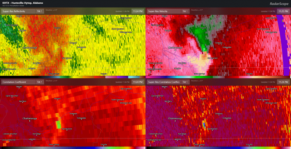
Not heard anything out of Ooltewah yet. I am hoping that the tornado weakened as rapidly as it intensified. The CC appeared to be weakening just as the intense circulation unraveled over Ooltewah proper. However, that went crazy fast and may've unfortunately hit some residential structures.
-
1
-
-
Ugh..
-
 1
1
-
-
Quite a number of QLCS tornadoes have occurred already in the semi-inear line moving out of LA. One in particular appears to have been quite violent near Monroe earlier.
-
1
-
-
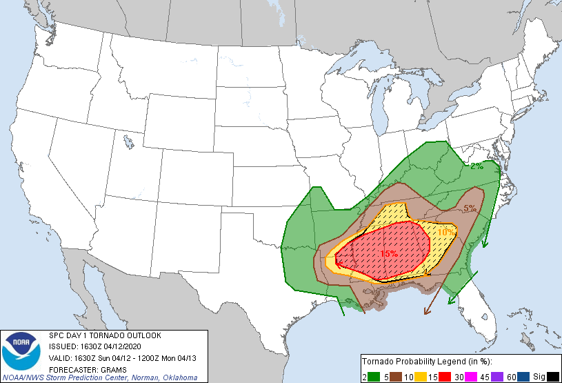
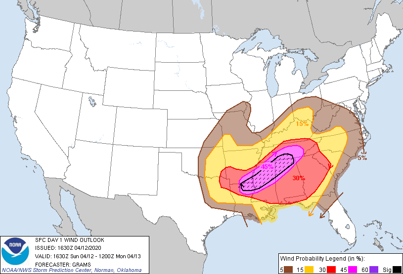
  SPC AC 121630

   Day 1 Convective Outlook
   NWS Storm Prediction Center Norman OK
   1130 AM CDT Sun Apr 12 2020

   Valid 121630Z - 131200Z

   ...THERE IS A MODERATE RISK OF SEVERE THUNDERSTORMS NORTHEAST
   LA...SOUTHEAST AR...MS...AL...WESTERN GA...SOUTHERN MIDDLE TN...

   ...SUMMARY...
   An outbreak of severe thunderstorms is likely through tonight, with
   the greatest threat expected from northeast Louisiana, Mississippi,
   Alabama, southern Middle Tennessee and western Georgia. Strong
   tornadoes, widespread damaging winds, and large hail are all
   possible.

   ...Synopsis...
   A complex forecast with multiple scenarios possible across a
   broad area from the Lower MS Valley into the TN/OH Valleys and the
   Southeast. A compact shortwave trough over the Edwards Plateau of TX
   will accelerate east-northeast into the Ark-La-Miss by this evening
   and towards eastern KY/TN by the end of the period, in response to
   continued amplification of a large-scale trough over the
   north-central states.

   ...Northwest LA to northern AL/middle TN...
   An ongoing MCS with a history of several confirmed but brief TDSs
   earlier this morning will continue to move east-northeast along an
   intensifying baroclinic zone across parts of northern/central MS
   into northern AL/middle TN. Tornadoes and damaging winds will be
   likely with this MCS which will include a mixed convective mode of
   bowing segments and potential supercells developing just ahead of
   the cluster on its southern flank.

   The presence of upper 60s to low 70s surface dew points in much of
   LA and southern MS will spread north and likely reach northern MS to
   western AL between 21-00Z. This should overlap strong low-level
   shear (0-1 km SRH of 400+ m2/s2) as the low-level jet strengthens
   and shifts northeast. The environment will favor embedded supercells
   capable of producing strong tornadoes and damaging winds, the most
   substantial of which may occur from northeast LA through
   north-central MS into northern AL and southern middle TN. There is
   still enough uncertainty with regard to convection outpacing
   stronger surface-based instability (especially with northeast
   extent), as well as the overall convective mode, to preclude an
   upgrade to High Risk.

   ...Southern MS to GA/Carolinas...
   To the south of the initial MCS crossing northern MS/AL into TN, a
   separate pre-frontal band of convection is expected to become
   sustained by early evening from southern MS into central AL. This
   convection will be well east of the synoptic cold front, in an
   environment with moderate surface-based buoyancy and very strong
   vertical shear. A broken band of embedded supercells appears likely
   to develop through the evening and overnight, with an associated
   threat for strong tornadoes and damaging winds. The pre-frontal
   convection should reach the western Carolinas by 09-12z.

   ...Lower Red River Valley to the OH Valley...
   An arc of convection will likely form later this afternoon just
   ahead of the compact shortwave trough and associated surface cyclone
   in eastern OK to northeast TX, within the left-exit region of the
   mid-upper jet. This convection will subsequently spread east then
   northeast across the Mid-South during the late afternoon/evening.
   The northward extent of destabilization in AR/western TN this
   afternoon/evening will depend largely on the intensity and extent of
   the early-day MCS moving from LA into northern MS.

   Still, steep midlevel lapse rates with the ejecting mid-level wave
   and strong deep-layer vertical shear will favor fast-moving
   supercells and line segments capable of producing large hail and
   damaging winds. The northeast extent of the damaging wind and
   tornado threat into tonight will depend largely on how
   widespread/organized the convection is across northern MS/AL this
   afternoon/evening, and the degree of low-level recovery in the wake
   of that convection.

   ..Grams/Bentley.. 04/12/2020

   CLICK TO GET WUUS01 PTSDY1 PRODUCT

   NOTE: THE NEXT DAY 1 OUTLOOK IS SCHEDULED BY 2000Z
   CURRENT UTC TIME: 1736Z (1:36PM), RELOAD THIS PAGE TO UPDATE THE TIME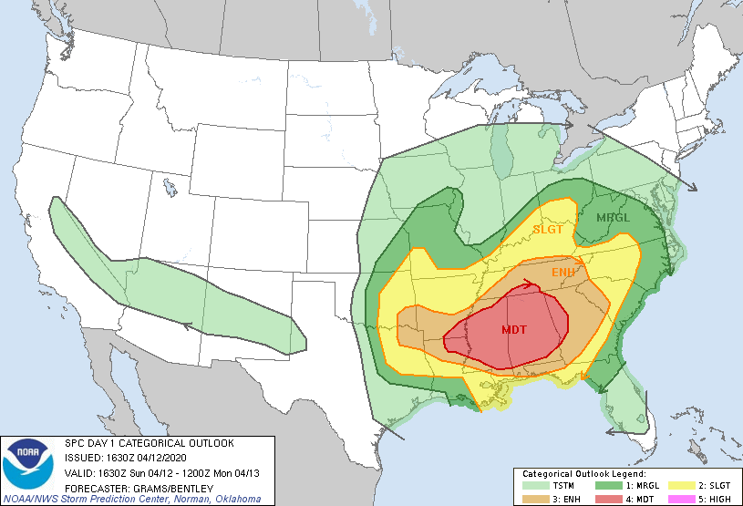
-
Incredible structures on those SCs even if they aren't producing tornadoes. Beautiful mesos and clearly damaging hail cores.
Edit: That meso intensified. Looks like it may've even briefly produced. There may've even been another brief TDS east of the main meso.

-
SREF posted in TN Valley subforum by@jaxjagman ...
If the virus wasnt going on right now i'd go towards Yazoo,Ms,but i'm not leaving the state.thumb.png.0c6e2d408c984126261d6c3d4f58de7b.png)
-
The coverage in the warm sector is large. People are expecting a string of pearls, however, these may very well be scattered cells in close proximity over a wide coverage area. The initial explosive convection in the warm sector that would be suspect and tornadic doesn't look particularly linear to me.I don't know - one could argue that a lot of these are discrete cells, and there are A LOT of UH tracks. This could indicate an outbreak.Edit: RE :18z HRRR. I should add that the convection on the backside of that warm sector does take on a more linear look, but not until after plenty of intial suspiciously discrete convection has already moved NE into the upper TN Valley.
-
Hahaha Reed Timmer Ric Flairing it.
-
Could see a scenario where modeling really doesn't start coming into line until around 18z tomorrow. This mainly due to differences in handling phase timing and tilt so far. You'd think within 24 hrs they should be close enough that those differences get ironed out for a better consensus. Perhaps? By that point we'll all be focusing on 3km mesoscales anyway.The GFS the same time shows the LP around the Delta the NAM is further N than the Euro,they aren't playing along very nicely even in the short range-
1
-
-
Not familiar with this model. Viper based? At any rate, reckon that's about as much a worst case scenario as I've seen. I actually lol'd when I saw this on the SE thread. Hopefully this is slightly overdoing things.
Edit: Nevermind, this is a proprietary model based off the WRF.
-
1
-
-
He does give a worst case scenario that would lead to a high end outbreak however. He explains different possibilities and why, which is why I shared.Unless I missing something, he doesn’t seem to think this will be a high end out break. -
Very good thread/discussion by Cameron Nixon, a post-grad atmospheric scientist doing his PHD work @ CMU. He seems to know his stuff. At any rate, knowledgeable enough to warrant sharing his thoughts on the upcoming event:
This comment in particular:
Given (likely) cloudiness and perhaps strong 850mb convergence, it is possible that elevated convection is most likely at least initially, before forcing encourages more of a linear/mixed-mode evolution. If supercells do "break the cap" initially, tornado threat will be realized.Edit: He also does point out a worst-case scenario based on nuances in the recent ECMWF runs that suggest a small extension of the shortwave during initial phase. This would amplify the low-level flow, increase instability and allow capping to break down ahead of the linear mode.
-
2
-
-
..and not often you see a hatched area that large for a Day 3 Moderate. Potential is key. Seriousness of the situation needs to get out early. If it becomes high risk, at least we had ample warning. If it doesn't pan out, better to have heeded the eyebrow-raising model guidance than to be too conservative and to regret those that were complacent I suppose.
-
3
-
-
-
Sharing this post concerning the SREF's sigtor probs from the SE forum:
I don't post here often, mostly lurk, but wanted to post the 21z SREF Sigtor probs for 21z on Sunday.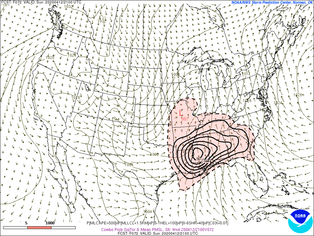
-
If nothing else, the lower Tennessee Valley is swaying more assuredly to a tornadic outbreak. The northern Valley is still in question at this point. The parameters are there however if the airmass trench keeps shifting north. Big *if* of course.
-
1
-
-
Hoping this is just nonsense and the models suck right now. Don't feel like hype-bust but this does look bad from a modeling perspective. Edit: Bad in that I don't like the way this is trending... don't want it, don't need it. Bust bust bust. Modeling for this event looks nasty right now but there is still plenty of time for this to not be a big bad monster outbreak.Getting dizzy yet ?
-
I agree with the whole trying to forecast a similar setup or expect another 4/27. Too many variables need to be dead nuts for that to occur. I seem to recall that 4/27 could have been even worse over the central Valley had the bulk of early onset precip along the warm front not lingered west of Knoxville. But by the time the outbreak had started, instability went nuts over the eastern Valley with warm southerly flow and it didn't matter there. Hence all the long-track tornadoes into the Chattanooga area to SWVA. That was an insane setup all for bad luck for the folks involved. Having said this, we may still be in for a bad outbreak Sunday.
-
1
-
-
Latest ENSO NMME forecast courtesy of@jaxjagman
NMME into fall


-
1
-
 1
1
-
.png.023032fe318573dc24f3526b85c6b8f4.png)


2020 Atlantic Hurricane Season
in Tropical Headquarters
Posted