

Windspeed
-
Posts
4,156 -
Joined
-
Last visited
Content Type
Profiles
Blogs
Forums
American Weather
Media Demo
Store
Gallery
Posts posted by Windspeed
-
-
It's just his guess. Though concentric banding is getting better organized, we have no way to know how that will evolve, even in the short term, or how quickly an ERC could progress. There is even a possibility that concentric eyewalls could develop and persist all the way into landfall with the outter eyewall not being intense enough to result in a weaker inner eyewall at landfall. All this stuff is a big unknown until it actually evolves IRL.Not a chance it gets down to 130 by LF in PR. You expect a ERC to take 35mph off it? Or do you feel there is something else not being mentioned that will reduce wind speed? -
Yes get used to seeing Jose's name in this thread because after impact on PR/VI, its 500 mb influence and how that evolves is the #1 major player concerning Maria CONUS interaction and track uncertainty.
-
 6
6
-
-
This is what I was concerned about. ECMWF filling Jose's 500mb vort enough to bring Maria back west. Fortunately, based on this solution, it still had Maria far enough east bringing it over signficantly cooler SSTs thanks to Jose before bring it nearto the Mid-Atlantic region. Maria would be a similar storm to Jose by that point.Imminent landfall, probably into NJ
What we have to watch for with modeling evolution the next few days is if the ECMWF begins to trend towards filling Jose's resulting mid-level weakness faster. That could allow more ridging bringing Maria further west in track over much warmer and untouched Gulf Stream SSTs.
-
2
-
-
Looking forward to recon video from the eye later. Should be a spectacular sunny stadium effect like Irma at her peak, only smaller.
-
16 minutes ago, wxeyeNH said:With the eye looking so good on infrared Im surprised the vis. shows a low cloud cover. We will know very shortly what's going on, recon getting close...
Low clouds are nearly always present at the 800 mb layer in an intense eye on visible satellite imagery. People make it seem like it's clear blue skies looking up from the surface, but it usually looks more like a haze with breaks and low thin stratus cloud clusters spinning around. You can see stars, sun and moon through them from the surface though.

-
1
-
-
The concentric banding really needs to get its act together and tighten in a lot closer to the eyewall before it will begin to abate low level convergence. That's really the only thing in structure that might weaken Maria before landfall. Man this looks intense...

-
Sure does...Certainly looks that way on infrared.
-
Recon should be in Maria's core in about 30 minutes. We'll see if she has deepened further. I suspect she has. Perhaps around 920 mb.
-
Maria's core is starting to pick up a little better detail on TJUA long range. Enough detail to discern that the eyewall looks very intense and stable. Also concentric banding closer to St. Croix is pretty distant from the eyewall. Basically I don't see anything yet that would suggest Maria's eyewall can't continue deepening this afternoon.

-
Yes, a small vortex/eyewall directly interacting with rugged terrain, even over a landmass as small as Dominica is disruptive. Not surprising to see the pressure rebound. With the eyewall completely back over water now, looking closed and still very organized, there will probably be a leveling off of the current pressure rise. But I would still expect a delay before any reintensification and deepening. Tough to forecast that. Will likley remain at least a Category 4 over night however. It may make another run at Cat 5 given the outstanding upper environment over the next day or two.It'll be interesting to see how Maria does now that it is back over the water. Such small cores can be impacted significantly by land interaction - hence the ~20 MB rise in a relatively short period. However, they can also get their act together in a hurry if the land interaction wasn't too damaging to the inner core - which I'm not sure it was based on the fact it only spent a few hours over land. We'll probably find out over the next two hours what the speed for any intensification might be.-
3
-
-
That temporary NW jog over the island since initial landfall was so cruel.
-
We loose satelite and cable when it clouds up good in my neck of the woods while these jokers still have WiFi during a cat 5.
They have underwater fiber. It makes a huge difference versus suspended lines like across the CONUS. As long as they don't get severed underwater.
-
2
-
-
The landfall scan...

-
2
-
-
129kt FL was last report but I don't think they had punched eye yet.
-
Still inbound..

-
They're still inbound.Recon not going to make it in time. Center looks onshore according to radar.
-
If recon still goes in to punch the eyewall, I'm going to be a bit nervous. They don't normally punch an eye as it is making landfall and a mountain range is involved. Perhaps a 4700ft peak is safe for turbulance if they avoid SW eyewall or they will turn SE once in the eye.

-
Even though Roseau is not in a protected harbor and they are exposed, they have a rocky and elevated shoreline. The incline from sea bottom, shoreline is steep in places and the general overall topography rises to inhabited ridges. Though the wind damage could be catastrophic, I am hopeful based on geography and Maria's small vortex, surge will be limited.There could be a major disaster in the making here and if anyone better connected than me (to large government or military resources) reads this, it would no doubt save lives down the road to begin plans for a rapid response, the local government will not only be overwhelmed, it could easily be obliterated. I envisage a combination of Homestead wind damage and Tacloban storm surge, thousands left with very little shelter and hundreds of injured in massive debris fields (all over the island basically but 75% of population lives in southwest quadrant). There will only be a small trickle of info coming out for 2-3 days but we could assume this need will exist starting in about an hour. Large French resources probably exist very close, although the way this thing is going, city of Basse-Terre will take quite a wallop and Pointe-a-Pitre a major storm surge so that will perhaps tie down those resources.This will be far worse than even St-Maarten. I don't think Roseau is protected at all by terrain or wind direction considerations because of the extreme intensity of this storm. Will be happy to be proven wrong but I expect the place to be flattened and exposed to 20-30 ft storm surge. (this also happened in 1780, and everything on Barbados was destroyed despite them being south of the eye).
-
1
-
-
West wall is crossing coastline.

-
Okay nevermind this. They just made their turn north up the eastern side. So a NE to SW pass is coming. Holy crap this is going to be right down to the wire.I don't see that recon has made their turn yet. The western wall is getting close to the eastern Dominica coast. We may not be getting that NE pass after all. Perhaps they got spooked. There is a serious incline of elevation that could produce some horrific turbulance. That may be it, folks. -
I don't see that recon has made their turn yet. The western wall is getting close to the eastern Dominica coast. We may not be getting that NE pass after all. Perhaps they got spooked. There is a serious incline of elevation that could produce some horrific turbulance. That may be it, folks.
-
1
-
-
Just looking at the radar and given forward motion, I think the pass through the NE eyewall will top everything on this first pass. This will be a Category 5.
-
4
-
-
Concentric banding developing. Recon will do a NW to SE pass first and they have time for a SW to NE as well. We should get the Full Monty.

-
22 minutes ago, Marmot said:Low shear
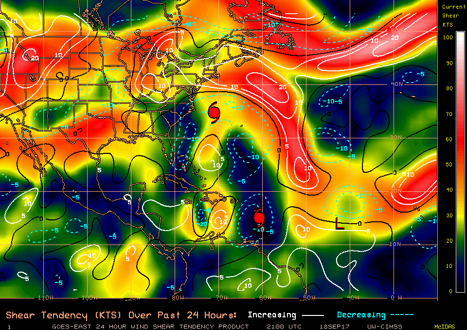
Got to hand it to both the GFS and ECMWF upper modeling. For four days straight, 300 to 200 mb maps all showed spectacular upper support evolving over the Lesser Antilles. It had me concerned as early as Wednesday. I just wasn't sure if the cyclone would develop and be positioned where it is now. All that is history.
Hurricane Maria
in Tropical Headquarters
Posted
The other bad aspect the NHC is beating the drum about is Maria's forward motion. This cyclone isn't exactly setting any forward speed records. Considering the weaker ridge a long duration vortex interaction with the island, it will take a while for the eyewall to traverse the Puerto Rican landmass. The combination of high terrain and 15-20 inches of rain in places in a rapid fashion is incredibly troubling. People there need to get away from ravines, creeks, streams, etc., most likley all these features are going to turn into raging torrents and rivers. Also get off of steep ridges as mudslides and mudflows will be an absolute certainty with this type of event. A high population is a risk.