

Windspeed
-
Posts
4,156 -
Joined
-
Last visited
Content Type
Profiles
Blogs
Forums
American Weather
Media Demo
Store
Gallery
Posts posted by Windspeed
-
-
Despite a larger eyewall (ERC is finished) reported by recon, Willa had struggled over night to suppress lingering convection associated with the decaying inner vortex. Also 10-15kt of analyzed southwesterly shear may have also been encroaching upon Willa's core entraining dry air and prolonging the replacement cycle process. That being said, there does appear to be some clearing out if the eye now on visible and Willa is moving over an area of 28-29°C SSTs. Some reorganization and deep convection of the new eye could allow a more steady state of intensity into landfall versus rapid weakening. Trough interactions are tricky. Regardless if Willa is still a major hurricane or category 2 at landfall, the windfield has grown and risk of surge remains. Areas of that part of the Mexican coastline are rather flat despite the nearby mountainous terrain. Speaking of, flash flooding due to prolonged southerly flow and orographic enhancement is already occurring in the higher elevations to the southeast in Colima.

-
Still forecast to make landfall on the Mexico mainland as a major hurricane, though obviously it could landfall on Las Islas Marias first.
000 WTPZ44 KNHC 230234 TCDEP4 Hurricane Willa Discussion Number 12 NWS National Hurricane Center Miami FL EP242018 900 PM MDT Mon Oct 22 2018 Willa's eye is no longer apparent in geostationary imagery, but an SSMIS overpass from 0049 UTC showed a remnant inner eye along the northern edge of a larger outer eyewall that has taken shape over the past few hours. The initial intensity has been lowered to 125 kt based on a blend of the latest Dvorak Final-T and CI numbers from TAFB. Given that the eyewall replacement cycle is well underway and that moderate southwesterly shear now affecting the hurricane is expected to increase, continued gradual weakening is forecast through landfall, and the new NHC intensity forecast through 24 hours is near or a bit above the FSU Superensemble. Despite the forecast decrease in the peak winds, Willa is expected to remain a dangerous major hurricane through landfall, and will bring life- threatening storm surge, wind, and rainfall hazards to Las Islas Marias and portions of west-central and southwestern Mexico on Tuesday. After moving inland, Willa will rapidly weaken, with dissipation forecast by Wednesday over the high terrain of Mexico. Moisture from the remnants of Willa is forecast to spread northeastward over northern Mexico and portions of Texas where a swath of heavy rainfall is expected midweek. The initial motion estimate remains northward, or 360/08. The track forecast reasoning remains unchanged, as Willa is expected to gradually recurve as it is steered by a large mid-level ridge centered to the east and a shortwave trough approaching from the northwest. The new NHC track forecast has been adjusted slightly left of the previous one due to the initial position and motion and lies along the eastern edge of the guidance envelope near the HCCA consensus aid. There continue to be differences in the forward speed of the cyclone as it approaches the coast, and the NHC forecast remains close to the forward speed of the consensus aids. Key Messages: 1. A life-threatening storm surge is expected Tuesday along the coasts of the Isla Marias, and along the coast of southern Sinaloa and Nayarit states in west-central and southwestern Mexico near the path of Willa. Residents should rush preparations to completion to protect life and property and follow any advice given by local officials. 2. Everyone in the Isla Marias, and within the hurricane warning area along the coast of west-central Mexico should prepare for life- threatening major hurricane winds associated with the core of Willa. Hurricane force winds will also extend inland across the mountainous areas of west-central Mexico as Willa moves inland. 3. Heavy rainfall from Willa is likely to produce life-threatening flash flooding and landslides over much of southwestern and west-central Mexico. FORECAST POSITIONS AND MAX WINDS INIT 23/0300Z 20.5N 107.2W 125 KT 145 MPH 12H 23/1200Z 21.5N 106.9W 115 KT 130 MPH 24H 24/0000Z 23.0N 105.8W 85 KT 100 MPH...INLAND 36H 24/1200Z 25.3N 102.7W 30 KT 35 MPH...INLAND 48H 25/0000Z...DISSIPATED $$ Forecaster Brennan -
ERC is now in an advanced stage.
-
Great Typo
Haha that's an awesome typo!
Recon is getting close.
Edit: Actually, scratch that. They were en route and even descending to an operational altitude, then suddenly did a 180° and are heading back over the Mexican mainland. Perhaps something is wrong?
-
Willa may be in a state of weakening upon landfall, but it may still be a major hurricane. It's going to be close. Either way it will be a strong impact nonetheless.
-
000 WTPZ44 KNHC 220232 TCDEP4 Hurricane Willa Discussion Number 8 NWS National Hurricane Center Miami FL EP242018 900 PM MDT Sun Oct 21 2018 Willa has continued to rapidly intensify this evening. Satellite images show a well-defined circular eye with a surrounding ring of cold cloud tops that are near -80 deg C over the southeastern quadrant. The initial intensity is set to 125 kt, which is near the latest Dvorak ADT estimates from CIMSS at the University of Wisconsin. Willa has strengthened at an incredible rate since genesis, intensifying from a tropical depression to a category 4 hurricane in less than 48 hours. Willa is gradually turning toward the right, with the initial motion estimated to be 340/6 kt. The hurricane is expected to turn northward on Monday as it moves around the western periphery of a mid-level ridge to the east, followed by a faster northeastward motion Monday night and Tuesday when a shortwave trough approaches the system. The models are in fairly good agreement, and only small changes were made to the previous NHC track forecast. On the forecast track, Willa is expected to move over Las Islas Marias on Tuesday and then move inland over southwestern and west-central Mexico Tuesday night or early Wednesday. The hurricane has certainty taken advantage of the near ideal environmental conditions and since these conditions will persist a little longer, some additional strengthening is shown in the short term. However, some fluctuations in intensity could occur due to eyewall replacement cycles. The models then show a gradual increase in shear and a decrease in available moisture around 24 hours, and these factors should cause a slow weakening trend. Regardless, Willa is forecast to remain a dangerous hurricane, bringing multiple life-threatening hazards to the coast of Mexico. Rapid weakening is forecast after the system moves inland and interacts with the mountainous terrain. The NHC intensity forecast lies near the high end of the model guidance through dissipation. Key Messages: 1. Willa is forecast to be a dangerous hurricane when it reaches the Islas Marias and the coast of southwestern Mexico by late Tuesday or Wednesday bringing a life-threatening storm surge and flash flooding along with damaging hurricane-force winds. A Hurricane Warning is in effect for these areas, and residents should rush preparations to completion to protect life and property and follow any advice given by local officials. FORECAST POSITIONS AND MAX WINDS INIT 22/0300Z 17.7N 107.2W 125 KT 145 MPH 12H 22/1200Z 18.6N 107.4W 135 KT 155 MPH 24H 23/0000Z 19.7N 107.5W 125 KT 145 MPH 36H 23/1200Z 20.7N 107.2W 115 KT 130 MPH 48H 24/0000Z 22.1N 106.2W 100 KT 115 MPH 72H 25/0000Z 26.2N 101.3W 30 KT 35 MPH...POST-TROP/INLAND 96H 26/0000Z...DISSIPATED $$ Forecaster Cangialosi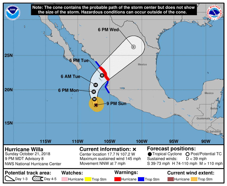
-
That's definitely a well-developed major hurricane. Though the explosive deepening was expected, it's still crazy to watch such rapid intensification unfold.

-
NHC is forecasting a Cat 4 now. It should be weakening prior to landfall though. Perhaps even falling below Cat 2 by the time Willa's core reaches the Mexican coast as some of the intensity modeling suggests. However, faster motion and track perpendicular to coastline could allow Willa to maintain major status into landfall. The states of Colima, Jalisco and Nayarit are all a mountainous/volcanic coastal region and too much land interaction there can significantly disrupt low-level inflow of a slow moving hurricane, especially a more adjacent track to the shoreline. Ultimately, landfall intensity will depend on trough interaction and trajectory of track versus the coastline. The eventual capture by the trough and NE motion may give Willa enough forward motion to the NE to avoid its own upwelling, but at the same time, strong southwesterly upper level flow may inflict increasing shear.
000 WTPZ44 KNHC 211443 TCDEP4 Hurricane Willa Discussion Number 6 NWS National Hurricane Center Miami FL EP242018 900 AM MDT Sun Oct 21 2018 First-light GOES-16 visible satellite imagery shows that Willa continues to become better organized, with a tightly coiled band of convection wrapping around the center. There has also been evidence of a small eye in recent microwave and infrared satellite pictures. Subjective and objective satellite intensity estimates range from 77 kt to 90 kt, and the initial intensity has been increased to 85 kt for this advisory. Willa is moving northwestward or 325/6 kt. The track guidance continues to indicate that Willa will move northwestward today, then turn northward on Monday, and then head north-northeastward on Tuesday between a deep-layer ridge that extends westward from the Gulf of Mexico and an approaching mid-level trough. The dynamical model guidance remains in good overall agreement on this scenario, but there are differences in how quickly Willa will accelerate north-northeastward. The UKMET and ECMWF are much slower than the remainder of the dynamical models, with the GFS and GFS ensemble mean the fastest. The NHC track forecast brings the center of the Willa onshore of the coast of southwestern Mexico within 72 h, and it lies closest to the HFIP corrected consensus, which is a little faster than the other consensus aids. The hurricane is expected to remain within low vertical wind shear and over warm waters of around 28 degrees Celsius during the next day or two. These very favorable conditions are expected to allow steady to rapid strengthening through Monday night, and the NHC forecast is near the upper end of the intensity guidance. By 48 hours, increasing southwesterly shear is forecast to initiate weakening, but Willa is likely to remain a very strong hurricane through landfall in southwestern Mexico. After landfall, rapid weakening and dissipation over the mountainous terrain of mainland Mexico should occur. Key Messages: 1. Willa is forecast to be a hurricane when it reaches the coast of southwestern mainland Mexico by late Tuesday or Wednesday bringing a life-threatening storm surge, dangerous winds, and life-threatening flash flooding, and hurricane and tropical storm watches are now in effect for a portion of the area. Residents in the watch areas should monitor the progress of this system and follow any advice given by local officials. FORECAST POSITIONS AND MAX WINDS INIT 21/1500Z 16.6N 106.7W 85 KT 100 MPH 12H 22/0000Z 17.2N 107.2W 95 KT 110 MPH 24H 22/1200Z 18.2N 107.6W 110 KT 125 MPH 36H 23/0000Z 19.3N 107.7W 120 KT 140 MPH 48H 23/1200Z 20.4N 107.5W 110 KT 125 MPH 72H 24/1200Z 23.3N 105.5W 80 KT 90 MPH...INLAND 96H 25/1200Z 26.5N 101.0W 20 KT 25 MPH...POST-TROP/INLAND 120H 26/1200Z...DISSIPATED $$ Forecaster Brown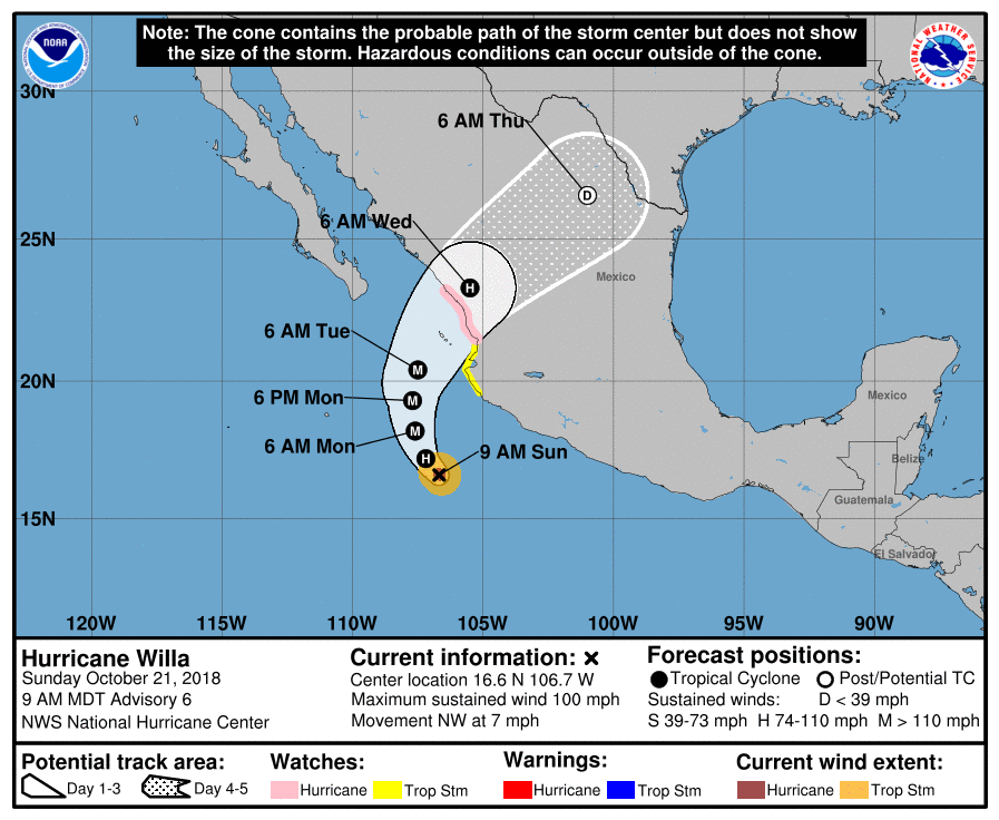
-
Willa has developed a pinehole eye. Should be upgraded next advisory. I may end up wrong here, but Willa is likely to outperform model intensity guidance. Low shear, small core and high OHC. It has a good 36-48 hrs remaining before increasing SW flow could impart any shear. Really the only thing stopping this from reaching maximum potential through Monday would be the onset of an ERC that takes too long. But ERCs can also be fast and result in a more stable eyewall versus an original tiny core like Willa's.
Edit: Pinhole, not Pinehole. lol..

-
000 WTPZ44 KNHC 210232 TCDEP4 Tropical Storm Willa Discussion Number 4 NWS National Hurricane Center Miami FL EP242018 900 PM MDT Sat Oct 20 2018 Willa has rapidly intensified since genesis occurred last night, and it is almost a hurricane. Geostationary satellite and microwave images indicate that banding features have become well established in all quadrants and the inner core has continued to organize. There is still no evidence of an eye feature, however. A blend of the latest satellite intensity estimates supports increasing the initial wind speed to 60 kt. The latest satellite fixes indicate that Willa is now moving northwestward at about 5 kt. The storm is expected to gradually turn to the right as it moves around the western periphery of a mid-level ridge. In response, a northwestward motion should continue for another day or so, followed by a turn toward the north on Monday. After that time, a faster north-northeast to northeast motion is expected when a shortwave trough approaches the system. The latest model guidance, except for the UKMET, show Willa making a sharper northward turn and at a faster pace. The NHC track forecast has been adjusted accordingly to be in better agreement with the latest consensus aids. This forecast is again faster than the previous one and shows Willa making landfall over west-central Mexico in 72 to 96 hours. The storm has taken advantage of near ideal environmental conditions of very low wind shear, high levels of moisture, and warm 29 deg C SSTs. These conditions are expected to prevail for another couple of days, and that should allow Willa to continue to strengthen rapidly. In fact, the SHIPS Rapid Intensification (RI) indices show about 90 percent chance of RI continuing during the next 24 hours. Based on this information and the latest model guidance, the NHC intensity forecast shows Willa becoming a major hurricane in a day or so. Some weakening is likely before Willa reaches the coast due to an increase in shear and a decrease in available moisture, but Willa is forecast to be a hurricane when it reaches the coastline. After landfall, rapid weakening is expected due to interaction with the rugged terrain. FORECAST POSITIONS AND MAX WINDS INIT 21/0300Z 15.7N 106.1W 60 KT 70 MPH 12H 21/1200Z 16.1N 106.6W 80 KT 90 MPH 24H 22/0000Z 16.9N 107.1W 95 KT 110 MPH 36H 22/1200Z 17.7N 107.5W 110 KT 125 MPH 48H 23/0000Z 18.7N 107.8W 110 KT 125 MPH 72H 24/0000Z 20.7N 107.3W 90 KT 105 MPH 96H 25/0000Z 24.1N 104.2W 35 KT 40 MPH...INLAND 120H 26/0000Z...DISSIPATED $$ Forecaster Cangialosi -
TS Willa is establishing a tight inner core with nice symmetrical radial anticyclonic outflow aloft. Expect hurricane intensity by daybreak Sunday and rapid intensification into Monday. Willa will be an intense major hurricane before making the forecasted NE turn.
-
000 WTPZ44 KNHC 201446 TCDEP4 Tropical Storm Willa Discussion Number 2 NWS National Hurricane Center Miami FL EP242018 1000 AM CDT Sat Oct 20 2018 A GMI microwave pass over the depression at 0916 UTC revealed that a tight inner core has developed, with a cyan and pink ring noted in the low-level 37-GHz channel. Outer convective banding has also been increasing, and a consensus of the latest subjective and objective satellite intensity estimates supports raising the maximum winds to 35 kt and designating the cyclone as Tropical Storm Willa. On an historical note, this is the first time that at least 21 named storms have formed within the eastern Pacific basin since the 1992 season. The microwave data suggest that Willa's center is a little farther south than previously estimated, and the initial motion is calculated to be westward, or 270/8 kt. The storm is already located near the western periphery of a mid-level ridge which extends across northern and central Mexico, and Willa is expected to slowly recurve around the ridge axis during the next 4 days. By the end of the forecast period, a mid-latitude trough located over the western U.S. is likely to cause Willa to accelerate toward the northeast in the direction of mainland Mexico. All of the track models agree on this general scenario, but there are some differences on how wide a turn Willa makes while it recurves. There are also some speed differences that appear to be related to how strong Willa will be when the mid-latitude trough becomes the main steering driver. The NHC forecast is very close to the previous forecast during the first 48 hours. After that time, the forecast has been nudged eastward since the GFS and ECMWF models are both near or east of the multi-model consensus aids. With a low-level ring already observed in microwave imagery, and Willa located in an environment of low shear and over very warm ocean water, the cyclone appears poised to go through a period of rapid intensification (RI). Several of the various RI indices are over 50 percent, and thus the NHC forecast favors the high end of the intensity guidance and explicitly shows rapid strengthening over the next 48 hours. Willa is expected to be moving more slowly by days 3 and 4 (about 3 kt), and upwelling of colder water could induce some weakening by that time. An increase in shear is likely to cause more significant weakening by the end of the forecast period. The new NHC intensity forecast is a bit higher than the previous forecast to account for the possibility of rapid intensification, and it shifts Willa's expected peak intensity about a day earlier. FORECAST POSITIONS AND MAX WINDS INIT 20/1500Z 14.8N 105.7W 35 KT 40 MPH 12H 21/0000Z 15.0N 106.5W 50 KT 60 MPH 24H 21/1200Z 15.3N 107.3W 65 KT 75 MPH 36H 22/0000Z 15.8N 107.9W 80 KT 90 MPH 48H 22/1200Z 16.6N 108.5W 95 KT 110 MPH 72H 23/1200Z 17.7N 109.0W 100 KT 115 MPH 96H 24/1200Z 19.0N 109.0W 90 KT 105 MPH 120H 25/1200Z 22.0N 107.5W 75 KT 85 MPH $$ Forecaster Berg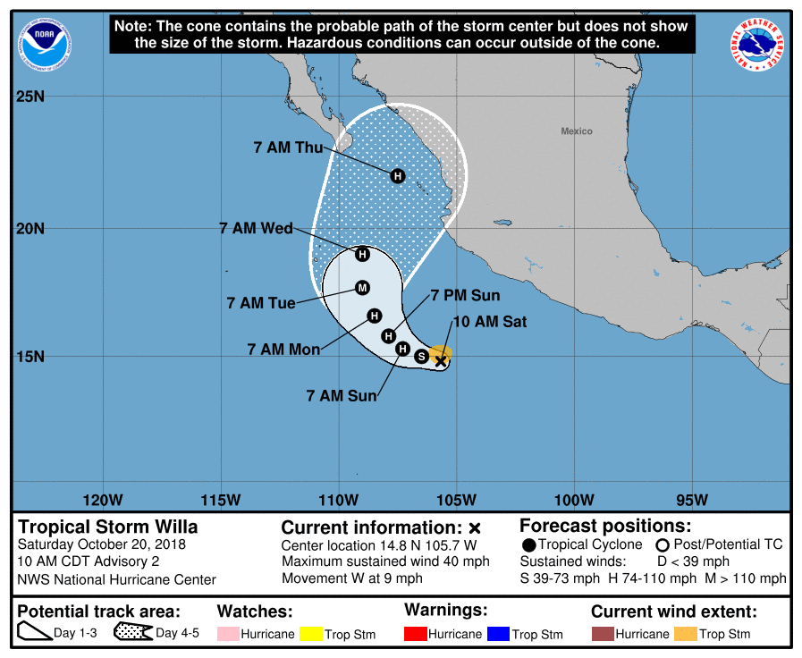
-
Here is the most recent ECMWF (10/19 12z) that resolves both systems quite well. Note how fast the small vortex of Vicente gets driven NNW up the coastline ahead of the larger and stronger vortex of Hurricane Willa:

-
We may have an interesting fujiwhara effect between two TCs in the EPAC developing near the Mexican coast in the coming days. The very small circulation of Tropical Storm Vicente spun up rather quickly this morning S of Guatemala and E of a strong northerly wind flow being funneled into the Gulf of Tehuantepec. Invest 99e is still slowly organizing further to the W and SW of the Mexican coast and will probably become TC Willa. If TS Vicente survives the Tehauntepec wind gap flow over the next 48 hours, modeling by both ECMWF and the GFS simulate possible interaction and play off both systems as they begin to pull N to NE in 5-7 days due to interaction with a mid-to-upper trough. In the meantime, if Vicente survives, it may continue W and NW to either get absorbed by an eventually stronger TC Willa that develops out of invest 99e, or be forced up into the Mexican coast to eventually phase with the resulting larger low pressure over the Gulf of California. Below is the 5 PM EDT discussion for Vicente and the 2 PM outlook for invest 99e. It will be interesting to see the wacky solutions by each of the OP model outputs versus eventual outcome as TCs in close proximity can have radically varied simulations in successive runs. Despite uncertainties on eventual intensities of either TC or their eventual points of landfall, there is increasing concern of severe life-threatening inland flooding over these mountainous coastal regions due to a steady feed of moist southerly flow and proximity to land.
000 WTPZ43 KNHC 192036 TCDEP3 Tropical Storm Vicente Discussion Number 2 NWS National Hurricane Center Miami FL EP232018 400 PM CDT Fri Oct 19 2018 Although tiny, the cyclone continues to display well-defined convective banding. The system's quick formation and small size make it difficult to have high confidence in its current intensity, and the various subjective and objective estimates range from T1.8/28 kt from the ADT to T3.0/45 kt from SAB. As a compromise, the intensity is set at 35 kt, which is closest to the TAFB estimate and the most recent SATCON number, and the depression is upgraded to Tropical Storm Vicente. As noted this morning, warm waters and low shear should induce further strengthening during the next 48 hours. On one hand, this intensification could be more than what is being indicated by the models, since small systems can have a tendency to gain strength quickly. On the other hand, Vicente will be interacting with a Gulf of Tehuantepec gap wind event during the next 48 hours, and the storm could end up ingesting some drier, more stable air into its circulation. The NHC intensity forecast favors the former scenario and is a little above the guidance envelope for the first 2-3 days. After day 3, an increase in shear, interaction with another possible tropical cyclone to the west, and possible interaction with land could all conspire to arrest the intensification trend, and weakening is expected by the end of the forecast period. It is also possible that Vicente could dissipate before the end of the 5-day period. This scenario is reminiscent of, and has similarities to, the interaction of Tropical Storm Ileana and Hurricane John back in early August. Vicente is moving very slowly northwestward, or 305/2 kt. The track models are indicating that the ongoing gap winds over the Gulf of Tehuantepec may have a greater influence of Vicente than previously thought, forcing the storm to turn west-southwestward in the next 24-48 hours. After 48 hours, Vicente should gradually enter the flow between mid-level ridging over Mexico and low pressure west of Mexico, causing it to turn back to the west and northwest on days 3 through 5. The new NHC track forecast is not too different from the morning forecast during that period, and it's closest to the paths shown by the GFS, HCCA, and FSSE guidance, which would bring the center close to the coast of Mexico later in the forecast period. There are considerable speed differences, however, and the NHC forecast splits the difference between the fast ECMWF solution and the slow GFS scenario. Even though Vicente should begin to slowly pull away from the coast tonight and on Saturday, heavy rainfall, with possible life-threatening flash flooding, is expected over portions of El Salvador, Guatemala, and southeastern Mexico during the next few days. FORECAST POSITIONS AND MAX WINDS INIT 19/2100Z 13.3N 92.2W 35 KT 40 MPH 12H 20/0600Z 13.6N 93.3W 45 KT 50 MPH 24H 20/1800Z 13.3N 94.2W 50 KT 60 MPH 36H 21/0600Z 12.9N 95.2W 55 KT 65 MPH 48H 21/1800Z 12.7N 96.5W 55 KT 65 MPH 72H 22/1800Z 13.7N 99.8W 55 KT 65 MPH 96H 23/1800Z 16.5N 103.0W 55 KT 65 MPH 120H 24/1800Z 20.0N 106.0W 45 KT 50 MPH $$ Forecaster BergShowers and thunderstorms associated with an area of low pressure centered a few hundred miles south-southwest of Zihuatanejo, Mexico, are gradually becoming better organized. Environmental conditions are expected to become increasingly favorable for further development, and a tropical depression is expected to form later today or tomorrow while the low moves west-northwestward at about 10 mph, well offshore of the coast of southwestern Mexico. * Formation chance through 48 hours...high...80 percent. * Formation chance through 5 days...high...90 percent.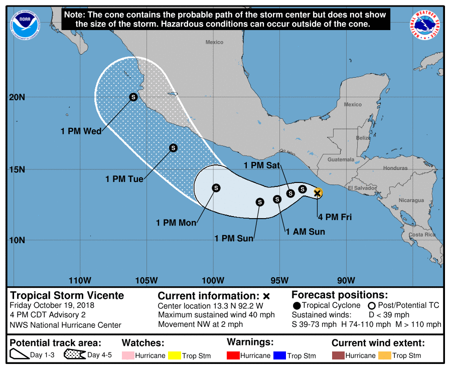
-
If low-level cloud cover moves out in time we could get a hard frost and freeze Sunday morning for the Eastern Valley. If nothing else, this weekend should finally kickstart Fall foliage into gear.
-
 1
1
-
-
Nice charted pressure vs distance relationship/comparison by Josh Morgerman [mention=19]hurricanejosh[/mention] between two of his Kestrel instruments, seperated by 3.7 miles. One left at his original chase location recorded 939.7 mb. It remained inside the eyewall. A second he had inside the hotel at his final chase position that measure 923.2 mb just inside the western periphery of the eye. A difference of 16.5 mb in 3.7 miles or 4.46 mb per mile. That is probably not exact as the pressure drop probably increased from point B to A. At any rate, that aligns pretty well to the last 919 mb center fix by recon at landfall, though central pressure may have actually dropped a mb or two lower as landfall was underway. Regardless, that is an impressively tight pressure gradient. Post analysis should definitely be interesting.
-
Dusting off the cobwebs in this thread. Tara is in the process dissipating in 24 hr near the SW Mexican coast; however, there is a new area associated with the CAG and 94L that may interact with a northerly jet over the Gulf of Tehuantepec. A number of GEFS and EPS suites have suggested cyclogenesis occurring south of Guatemala and is climatologically favored in the current setup. Why it's worth watching is that some of the guidance shows signficant intensification in 3-5 days and also the possibility of a mid-to-upper weakness or trough being modeled late in 7-10 day range that could pull the TC into the S. Baja or Sinaloa region Mexico.
A tropical wave located over western Nicaragua, southwestern Honduras, and eastern El Salvador will move westward into the eastern Pacific Ocean later this evening. The combination of the wave and a strong northerly wind event over the Gulf of Tehuantepec is expected to develop a low pressure system a couple of hundred miles south of Guatemala and southeastern Mexico by late Wednesday. Environmental conditions are forecast to be conducive for additional development, and a tropical depression is likely to form by late Thursday or early Friday while the system moves west-northwestward near or just offshore the coast of southern Mexico. * Formation chance through 48 hours...medium...60 percent. * Formation chance through 5 days...high...90 percent-
1
-
-
Signature win for you guys. Maybe y’all are finally putting it back together.
If we can just keep improving. I don't expect a miracle against Alabama, they show improvement and still get smashed; however, for the first time since before the Florida debacle, I am entertaining the possibility of 7 wins and a bowl. Feels good, man.-
1
-
-
000 WTNT43 KNHC 132036 TCDAT3 Post-Tropical Cyclone Leslie Discussion Number 70 NWS National Hurricane Center Miami FL AL132018 500 PM AST Sat Oct 13 2018 After a total of 70 advisories, long-lived Leslie has become post-tropical just west of the coast of Portugal, finally succumbing to the combination of cool waters, strong vertical wind shear, and interaction with an approaching cold front. The air mass ahead of the cyclone has moistened up in the low levels with Faro, Portugal, reporting a dewpoint of 70F/21C, but the dewpoints across central and northern Portugal ahead of Leslie are only in the low-60F range, which is not indicative of a tropical air mass. Thus, the cyclone is now a powerful post-tropical low pressure system that even has a partial eye noted in the most recent 2000Z Portuguese composite radar imagery. After landfall, rapid weakening is anticipated, and Leslie is forecast to degenerate into a broad low pressure area over or just north of Spain by late Sunday. Leslie is moving quickly toward the northeast or 050/30 kt. Post-tropical Cyclone Leslie should continue in a fast northeastward direction for the next 12-18 hours, making landfall near or just south of Porto, Portugal by 14/0000Z. This forecast motion is consistent with the previous advisory and the latest track model guidance. The meteorological services of Portugal and Spain are handling hazards information for their respective countries via local weather products. This is the last National Hurricane Center (NHC) advisory on this system. Key Messages: 1. Leslie is expected to bring near hurricane-force winds to portions of Portugal later tonight as a powerful post-tropical cyclone. Gale-force winds are also likely to affect portions of northwestern and northern Spain tonight and Sunday. 2. Leslie is expected to produce rainfall amounts of 25 to 75 mm (1 to 3 inches) with isolated amounts as high as 125 mm (5 inches) across portions of Portugal and Spain, which could cause flash flooding. 3. For more information on Leslie, interests in Portugal should refer to products from the Portuguese Institute for Sea and Atmosphere at www.ipma.pt. Interests in Spain should refer to products from the State Meteorological Agency at www.aemet.es. FORECAST POSITIONS AND MAX WINDS INIT 13/2100Z 40.5N 9.5W 60 KT 70 MPH...POST-TROPICAL 12H 14/0600Z 43.0N 4.9W 35 KT 40 MPH...POST-TROPICAL INLAND 24H 14/1800Z...DISSIPATED $$ Forecaster Stewart -
I'm seeing improvement. Yes, Tennessee won. But there appears to be a change or evolution occurring right before our eyes. The Vols had no business beating Auburn at their stadium. I didn't expect the win today, nor do I expect them to best Alabama. But they are focusing on their assignments and plays much better. Hell, it's a night and day comparison.
-
3
-
-
Noon hour and the temp is holding at 47 degrees. Summer to winter in a few days. Second observation. If your offense is struggling, play Tennessee and it will work much better.
I'm just happy we're still in the game
 ...for now.
 -
000 WTNT43 KNHC 131433 TCDAT3 Hurricane Leslie Discussion Number 69 NWS National Hurricane Center Miami FL AL132018 1100 AM AST Sat Oct 13 2018 Despite Leslie moving over 20C ocean and being embedded within strong shear, satellite data indicate that Leslie has maintained its deep warm core and is running ahead of a cold front. Although convection has weakened considerably, Dvorak estimates indicate that the winds are still 65 kt. All indications are that Leslie will acquire extratropical characteristics in the next several hours, and by the time it reaches the Iberian peninsula later today, the system will be a powerful post-tropical cyclone. After landfall, rapid weakening is anticipated, and Leslie is forecast to degenerate into a broad low pressure area over Spain in a day or so. Leslie is racing toward the northeast or 055 degrees at about 29 kt while embedded within the fast mid-latitude westerlies. A continued northeastward motion with gradual decrease in forward speed is anticipated in the next 12 to 24 hours. This is consistent with most of the track guidance, which unanimously brings the core of the post-tropical cyclone over the Iberian peninsula tonight. The meteorological services of Portugal and Spain are handling hazards information for their respective countries via local weather products. Key Messages: 1. Leslie is expected to bring near hurricane-force winds to portions of Portugal late today as a powerful post-tropical cyclone. Gale-force winds are also likely to affect portions of western Spain tonight and Sunday. 2. Leslie is expected to produce rainfall amounts of 25 to 75 mm (1 to 3 inches) with isolated amounts as high as 125 mm (5 inches) across portions of Portugal and Spain, which could cause flash flooding. 3. For more information on Leslie, interests in Portugal should refer to products from the Portuguese Institute for Sea and Atmosphere at www.ipma.pt. Interests in Spain should refer to products from the State Meteorological Agency at www.aemet.es. FORECAST POSITIONS AND MAX WINDS INIT 13/1500Z 38.0N 12.6W 65 KT 75 MPH 12H 14/0000Z 40.0N 8.0W 50 KT 60 MPH...POST-TROP/INLAND 24H 14/1200Z 41.5N 4.0W 30 KT 35 MPH...POST-TROP/INLAND 36H 15/0000Z...DISSIPATED $$ Forecaster Avila -
Leslie is coming in fast and aquiring extratropical characteristics now. Looks like it will complete transition to a post-tropical storm just before landfall. That low-level jet streak on the southern side and sting jet may still force surface winds that pack quite a wallop however.

-
I've spammed the tropical ans SE subforums, might as well deposit this here:
-
3
-
 1
1
-
2018 E. Pacific Hurricane Season
in Tropical Headquarters
Posted
For posterity, this was the last VDM on second pass a few hours ago. There will be no more flights into Willa. Of note was the 26 NM eye and the absence of an inner eyeband. Also the new eye was open to the SW at the time, typical of southwesterly encroachment of strong mid level flow.
000
URPN12 KNHC 231641
VORTEX DATA MESSAGE   EP242018
A. 23/16:14:00Z
B. 21.53 deg N 106.80 deg W
C. 700 mb 2802 m
D. 966 mb
E. 115 deg 9 kt
F. OPEN SW
G. C26
H. 89 kt
I. 138 deg 16 nm 16:09:00Z
J. 231 deg 109 kt
K. 139 deg 15 nm 16:09:30Z
L. 97 kt
M. 313 deg 9 nm 16:16:30Z
N. 057 deg 91 kt
O. 313 deg 16 nm 16:18:30Z
P. 13 C / 3064 m
Q. 15 C / 3047 m
R. NA / NA
S. 1234 / 07
T. 0.02 / 1 nm
U. AF309 0224E WILLA OB 15
MAX FL WIND 109 KT 139 / 15 NM 16:09:30Z
MAX FL TEMP 16 C 313 / 8 NM FROM FL CNTR
;