-
Posts
4,156 -
Joined
-
Last visited
Content Type
Profiles
Blogs
Forums
American Weather
Media Demo
Store
Gallery
Posts posted by Windspeed
-
-
I posted this last night in the main Atlantic discussion thread. My thoughts haven't changed. Anxious to see if the 12z ECMWF release in about an hour continues to kick out Jose much faster for downstream implications with a future Maria and the CONUS. Obviously the more immediate dire cause to worry is the Antilles.
Big changes in the 00z ECMWF downstream. It still brings a hurricane through Lesser Antilles, PR/DR, but swiftly ejects Jose OTS and rebuilds heights over the Mid-Atlantic region. That screams CONUS threat. Also the 500-200 mb analysis looks sobering with regards to both GFS snd Euro through 5 days. We need the vort to take as long as possible in consolidating a core. Otherwise, in the event it gets going, I see little in the way of preventing a period or periods of significant rapid intensification either before or up until interaction with the Greater Antilles. Still too early to rule out the possibility of more latitude gained and another sweep through the more northern Lesser Antilles/Virgin/PR islands as well. And of course the more southern track into Hispaniola is always a recipe for massive loss of life. We don't even have a classified system yet and I'm getting nervous mainly because anywhere near that region right now seems cruel by the Gods. Either way it doesn't look good as this won't avoid land. Best we can hope for is slow development, fast motion and a weaker cyclone.
Edit: Jtm12180, if you don't mind maintaining, updating and editing the title of the thread over the coming days, this can continue on as the main discussion thread for Maria.
-
 2
2
-
-
This would be the place.Not sure if where this goes... so if not here please tell me where
-
Looks like the ERC occurred in best case scenario with landfall.
-
I think they might be a little too north in their forecast track. Of course it could gain a more WNW motion between now and landfall, but it really looks to be bullseyeing the mouth of the Palanan River.
-
it's not going to stop at the sparsely populated coast. i shouldnt have to explain that tropical cyclones have inland effects, especially when we consider mountainous terrain and poor people. this is TC's 101.
The forecasted location of landfall receives more severe landfalling cyclones than any place on Earth. That combined with the mountainous terrain of the region probably has a lot to do with the far less densely populated geography as compared to the rest of the Philippines. However, there are small villages and townships still located along the coastline of northeastern Luzon. Hopefully the center makes landfall where one of those villages aren't located.
Additionally, you are correct about the threat of inland flooding. This typhoon has a powerful circulation with a very low pressure. As it pushes west, it will be a big threat to higher populated regions of central and western Luzon. That risk can certainly not be downplayed.
Edit: Divilacan Bay has several small coastal townships that are the closest to the current projected landfall point. That area was also blasted by Super Typhoon Megi in 2010. Inland flooding from that typhoon displaced 200,000 people as it moved across Luzon.
-
Well the 18z report had the pressure jump back up to 983hPa (50hPa jump in 1 hour lol)... 933hPa seems pretty high given the island was under the eye for a moment... maybe it bottomed out in between reports??
also winds down to 64kph and 90kph in Itbayat and Basco, respectively... i'm afraid to see the reports out of there today, home to about 18k people
Ok, great! It wasn't showing any changes for several hours. Glad they're up. Anxious to see what they have to report besides.
-
Itbayat, the island right in the eye, was last reporting N winds at 112mph with SLP at 933hPa...
Data equipment and communications obviously failed at the airport on Itbayat.
-
The last report from the airport in Banco, which looks like it positioned just under the southern and southeastern edge of the intense eyewall, reported sustained SW winds of 96 mph and gusts to 116.
https://www.wunderground.com/ph//basco/zmw:00000.1.98135
No reports out of the island of Itbayat.
EDIT: Whooooa there... Banco airport last report is S wind @ 122 mph, 150 mph gust. I don't think it was under the worst of the backside eyewall either.
Also looks like they're getting raked with a nasty intensifying outer eyewall.
-
Meranti made its first landfall in the Batanes on the island of Itbayat.
-
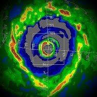
Think I'm buying that 160 kts now. May be even higher. Very symmetrical and expansive cold ring and the eye has further warmed. Really impressive system. In reference to the comparison to Haiyan earlier, Haiyan had a slightly colder ring, but it may have been low-balled on its peak intensity estimates anyway.
-
Very close call for the southern tip of Taiwan. The cyclone will probably have a larger core by the time it is at closest proximity there. Even if the inner eyewall doesn't make landfall, it's very likely a concentric outer wall will impact land and they will experience typhoon force winds.
For later today, the 06 HWRF has the northern Batanes nearly in the southern eyewall. The town of Banco is in the NW inlet of Batan proper. They will likely experience typhoon force winds even if the eyewall misses the island to the north.
-
Yeah, looks like model consensus has shifted south as has JTWC's official forecast. Looks like the core will miss Taiwan and China's mainland will be dealing with a stronger intensity at landfall than previously forecast. This could end up the worst direct wind impacts at landfall for China for many years. The core will likely weaken and drop down to upper Category Three status due to internal reorganization and an expansion of pressure gradient /wind field, but Meranti may have a much larger core by then, affecting a larger area of shoreline with typhoon force winds.
-
JTWC now forecasts Meranti to be 160 kt in 6 hrs (2:00AM Eastern). Isn't that close to Haiyan's peak intensity?
Haiyan was at a much lower latitude and had better upper tropospheric forcing. Probably the most incredible structure and symmetry we've ever seen in a tropical cyclone. I don't think Meranti can eclipse that. Inevitably, it is going to go through an internal structural change. It may have even peaked. As has been repeated, I wish they had recon over there. -
Wow, this may reign supreme for 2016. Absolute monster...

-
I still can't get over the duration of the actual tornado. i mean, you usally see a tornado cross a road in 10 seconds, or other videos it's moving fast, and you only see a couple seconds of it in 1 spot. But between the convenience store video, and some others, and hearing that it lasted up to 2-3 minutes in some places is just unfathomable.
A .75-1 mile wide wedge tornado with roughly 40mph forward motion combined with EF5 intensity; the circulation had to have some pretty intense inflow. I would consider that the reason it lasted so long wasn't necessarily because folks were inside the condensation of the wedge for 2-3 minutes, but were getting hammered with 60-100mph wind gusts 30-40 seconds before and after it plowed through them. I can't imagine the terror of experiencing such intensity for so long when everything around you is obliterated and the shrapnel-laden wind is basically the equivalent of a shotgun blast.
-
An amazing story from a stormchaser/doctor from Florida who was on the storm and helped out at Freeman hospital. Some of it is a bit 'gory' and he does talk about having to make the decision to let someone die so others could be helped.
This may be the most real and disturbing literature I have read with regards to the events that unfolded that day. For all the fascinating aspects of severe weather, the human aspect of loss and death is something that gets separated from science, statistics and the curiosity we all share. We all pour over "the incident" as this thing of wonder and amazement. We all live vicariously through those that experience natural disasters first hand. But in the telling of a personal experience, such as this one, you feel the pull on that place in your guts that makes you a human being. Thanks for posting this, Jomo. Glad you and yours survived unscathed, physically, at least.
-
OK, so not nearly as short as we all first thought. Wasn't the initial estimate like 4 mi or something like that? We all couldn't believe such a strong tornado could be so short-lived. 22 mi makes a lot more sense.
Also, does anyone have a clear idea of the circulation's translational speed as it passed through Joplin? I had thought it was very fast-- that it barreled through at well over 40 mph-- but the big article posted above (several pages back) said it was more like 10 mph. Any thoughts, anyone?
A speed of 10mph is quite puzzling and this must be an error. If you match NEXRAD scans with the 22 mi damage path, it looks like the center of couplet was over Newton RD just SW Joplin around 22:33:52 GMT. At 22:42:47 GMT, the circulation is distinguishable by an enormous debris ball. The couplet weakens and dissipates around 23:05:02 GMT roughly 10-12 mi ESE of Joplin. If we loosely estimate a touch down around 22:30 and dissipation at 23:00, that would gives us 22 mi traveled in 30 minutes, which is 44mph. Granted, this is a loose estimate. A more exact approximation with the NEXRAD scans and spotter reports might give us something at or just shy of 40mph, which I believe is the official speed documented by the NWS.


Hurricane Maria
in Tropical Headquarters
Posted
Banding is getting stronger. And I agree that the center may be south of track and model initialization. It was difficult to define an exact location earlier but that is no longer the case. This looks like a tropical storm. Would be surprised if this isn't upgraded to Maria at the 5 PM EST advisory. This is getting together fast.