

Windspeed
-
Posts
4,156 -
Joined
-
Last visited
Content Type
Profiles
Blogs
Forums
American Weather
Media Demo
Store
Gallery
Posts posted by Windspeed
-
-
2 hours ago, cmasty1978 said:That eye video is still amongst the best video ever.
Here is a longer version with footage from the eyewall.
-
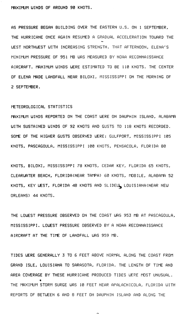
Here's a blast from the past: Anyone remember Major Hurricane Elena? It is another example of a hurricane that intensified significantly while over the shallow shelf waters of the northern Gulf. Elena reached upper Category 3 intensity with maximum estimated winds of 110 kts, but did weaken slightly to 100 kts in the hours just before landfall near Biloxi, Mississippi. I think we should realize, however, that Elena was its own worst enemy. It spent nearly four days in the same general region of the Gulf. The circulation took on slow and erratic movement ENE before looping sharply back to the WNW. This motion was due to interaction with a fast moving weak upper level shortwave trough that lifted and left Elena behind. The 500 mb weakness filled and allowed a ridge to take the wheel. Prolonged meandering and drift of the circulation likely did upwell cooler water from the previous days. This combined with the core's close proximity to the coast on its WNW track prior to landfall perhaps did prevent Elena from becoming a Category 4. The highest official coastal measurements were 92 kts sustained with 118 kts gust on Dauphin Is., Alabama, and gusts of 105 kts in Gulfport, Miss.
Elena is also one of the few early and rare moments where a successful storm chaser was lucky enough to have a quality camera on the ground inside the eye at landfall. The chaser filmed the clear blue sky overhead and the beautiful concave eyewall seen @ 1m 20s. A stunning shot made even more impressive that this was captured in 1985.
-
115 kts ... massive wind radiii:
6 HOUR SUMMARY AND ANALYSIS. TYPHOON 25W (LAN), LOCATED APPROXIMATELY 293 NM SOUTH-SOUTHEAST OF IWAKUNI, JAPAN, HAS TRACKED NORTH-NORTHEASTWARD AT 22 KNOTS OVER THE PAST SIX HOURS. ANIMATED ENHANCED MULTISPECTRAL SATELLITE IMAGERY DEPICTS A WEAKENED SYSTEM AS THE ONCE LARGE EYE FEATURE IS NOW OBSCURED BY DENSE OVERCAST LAYER WHILE EXHIBITING FRONTAL CHARACTERISTICS. HOWEVER, A 220441Z 89GHZ AMSR2 IMAGE SHOWS A SYMMETRIC RING OF DEEP CONVECTION STILL MOSTLY INTACT WITH ONLY PARTS OF THE SOUTHERN EDGE ERODING AWAY, LENDING HIGH CONFIDENCE IN THE INITIAL POSITION. THE INITIAL INTENSITY IS ASSESSED AT 115 KNOTS AND IS BASED ON AGENCY DVORAK ESTIMATES RANGING FROM T5.5 TO T7.0 (102 TO 140 KNOTS) AND A 220542Z SATCON ESTIMATE OF 120 KNOTS. UPPER- LEVEL ANALYSIS SHOWS THE POINT SOURCE OVER TY 25W NOW DISRUPTED AS IT INTERACTS WITH THE WESTERLIES. CURRENTLY TY 25W IS ACCELERATING POLEWARD ALONG THE NORTHWESTERN PERIPHERY OF THE DEEP LAYERED SUBTROPICAL RIDGE.Near or at landfall:
FORECASTS: 12 HRS, VALID AT: 221800Z --- 34.6N 138.3E MAX SUSTAINED WINDS - 085 KT, GUSTS 105 KTWIND RADII VALID OVER OPEN WATER ONLY BECOMING EXTRATROPICAL RADIUS OF 064 KT WINDS - 045 NM NORTHEAST QUADRANT 065 NM SOUTHEAST QUADRANT 065 NM SOUTHWEST QUADRANT 050 NM NORTHWEST QUADRANT
RADIUS OF 050 KT WINDS - 180 NM NORTHEAST QUADRANT 200 NM SOUTHEAST QUADRANT 175 NM SOUTHWEST QUADRANT 120 NM NORTHWEST QUADRANT
RADIUS OF 034 KT WINDS - 360 NM NORTHEAST QUADRANT 385 NM SOUTHEAST QUADRANT 375 NM SOUTHWEST QUADRANT 370 NM NORTHWEST QUADRANT
-
54 minutes ago, cmasty1978 said:people can read the posts and decide themselves about the hype.
it's all love, man. i like your posts. but i am just staking out a strong position. the storm is increasingly looking like crap, the JTWC forecast is loltastic, and japan can handle it.
They can handle a Cat 2/3, yes, they have sea walls and well built structures. But that's besides the point. Even a Cat 2, don't take it seriously and it hits a densely populated area, see what happens. And just based on current motion, 15-20kt of weakening is probably close to the mark. It wouldn't be good and it will cause destruction. Nobody was hyping this.
Edit: Current intensity is 125 kts and that may even be high. Earlier, when Lan looked a lot better, mind you, I made the 15-20 kt comment based on its appearance versus rapid forward motion. It's down to 125 kts. So give me the benefit of the doubt of 20 kts. You win. It will clearly weaken more than 20 kts. Probably 30 kts by landfall. Congratulations. I apologize for overhyping a 135 kt typhoon based on a worry of rapid motion. A Cat 2/3 landfall was forecast throughout and that is likely what it will be. Never called for anything higher, but you are correct. I insinuated hype with the word "worry" that it wouldn't weaken below Cat 3. It most likely will. Cheers!
-
That is your definition of hype? The core is in rapid motion. It's a worry vs I should just call it a windy day and move on?everyone knows i am ridiculous. that's irrelevant, though. i am also usually right.3 hours ago you said this:
this will definitely be wrong. by a bunch.
-
Please quote me hyping this typhoon. Quote any words. I beg you. You are ridiculous.japan is going to be just fine. they have great building codes...and look at the satellite, dude...its pooping out. -
I just do not see what your point is here. Who has made a call this will landfall as a Super Typhoon? Look at the forecast. It's still serious for Japan.you can totally downplay a 135kt storm that is in the middle of the ocean. what matters is what it is when it hits something. and when it hits something it's going to be pretty run of the mill....maybe even garden variety (shout out to my hurricane nate weenies). i'll be fine with eating a fat plate of crow if it turns out to be a disaster.
-
Also, NOBODY in this thread has been overhyping Lan. Not in the least. Get real.
-
Good thing that's not how we alert the public. You don't downplay a 135kt cyclone. Yes, the core may degrade to absolute crap by landfall. You want to base your advisory on that call. Have you ever been in a Cat 2/3 storm? This will be destructive. Hopefully it will weaken and that destruction will be mitigated.let's just leave it be for now and we can see how it plays out. i am still on team "blustery day with lots of twitter videos of waves". -
Haha. That's clearly your opinion. I see this as a powerful system that is going to make landfalll in a densely populated region. All based on perspective I suppose.lan is definitely hot garbage and has been for its entire existence. the WPAC is the land of gods. show some respect to real legendary typhoons. let this one go.
135kt max and extratropical turning crap into japan is zzzzz -
Perhaps in 8-10 hrs, but the perspective that it's falling apart based on current satellite presentation isn't good sound meteorology. We all knew the system was going to weaken based on the environement. But Lan isn't exactly hot garbage.you've got way too much faith in this system. just throw on the loop. this is going to look terrible in 8-10 hours.
-
1 hour ago, cmasty1978 said:i don't know, man...it's really going downhill the last few frames
Define "really going downhill"? If convection were falling apart, I'd concede. But this is classic tilting due to mid-level flow. Only, at present, the core is moving rapidly enough to counter it. That northern eyewall must still be quite fierce with such intense convection wrapped around it. Yes, you will have an assymmetrical appearance outside the core with baroclinic influence and increased southwesterly flow, but the core itself around the eyewall remains symmetrical and intact. This is still an intense typhoon. Hopefully it will begin to weaken significantly for the sake of impact on a highly populated region.
-
The center may be slightly tilted as well. Southerly flow is screaming. This is still an intense typhoon though. I am a bit worried this won't weaken more than 15-20 kts prior to landfall ue to rapid forward motion.Taken a big jog west of the forecast track the past few hours. Moving due north as far as I can tell. -
It's nice to have some recon surface obs for once in the WPAC to back up satellite estimates. I will say that Lan looks even better than it did when they acquired their dropsonde data yesterday.
EDIT: ADT ranged from 5.9 to 6.3 during the time they would have been in the eyewall.
At present, ADT CI # is: 6.8 / 922.9mb/134.8kt
JTWC 21/2100 discussion:
QuoteSUPER TYPHOON (STY) 25W (LAN), LOCATED APPROXIMATELY 303 NM EAST OF KADENA AB, HAS TRACKED NORTH-NORTHEASTWARD AT 18 KNOTS OVER THE PAST SIX HOURS. ANIMATED ENHANCED INFRARED SATELLITE IMAGERY DEPICTS A SYMMETRIC EYEWALL SURROUNDING A 38NM ROUND EYE. UPPER-LEVEL ANALYSIS INDICATES EXCELLENT OUTFLOW, PARTICULARLY POLEWARD, WHICH IS TAPPING INTO THE MIDLATITUDE WESTERLIES OVER JAPAN. A 211825Z NOAA-19 89GHZ IMAGE SHOWS AN EXTENSIVE BAND OF DEEP CONVECTION OVER THE WESTERN SEMI-CIRCLE ASSOCIATED WITH A COLD SURGE AND STRONG CONVERGENT FLOW. AS A RESULT, THE 34-KNOT WIND RADII ARE EXTENSIVE AS EVIDENCED BY SURFACE WIND OBSERVATIONS OVER THE RYUKYU ISLANDS RANGING FROM 30 TO 45 KNOTS. THE INITIAL INTENSITY IS ASSESSED AT 135 KNOTS BASED ON DVORAK INTENSITY ESTIMATES RANGING FROM T6.5 (127 KNOTS) TO T7.0 (140 KNOTS). THE STY ESTIMATE WAS VALIDATED YESTERDAY BY AIRCRAFT RECONNAISSANCE DATA FROM JAPAN WITH MAXIMUM WINDS AND MINIMUM SLP IN THE EYEWALL SUPPORTING AN INTENSITY OF 125 TO 130 KNOTS.
-
 1
1
-
-
I wonder if Lan will be intercepted by reconnaissance aircraft. Last year, there were several publications that members from Nagoya University and the Meteorogical Research Institute were going to conduct missions into powerful typhoons beginning this year. Granted, the 2017 WPAC season has been slow. But if ever there was a typhoon to start data gathering missions, especially considering the threat to Japan, you would think Lan would be it.
https://weather.com/news/weather/news/typhoon-observation-western-pacific-recon-aircraft
It would be awesome to have a dropsonde in this big powerful eyewall. Sometimes Dvorak underestimates large eyewalls. I recall Irma this year in the Atlantic was underestimated versus some of the recon measurements, though that hurricane was imbedded in a higher background pressure regime.
Edit: Well I just stumbled across this info on another board. They did not include any obs but confirms the flight occurred. Article is Japanese, here is the Google translation:
QuoteTyphoon 21 's "Eye" Drop Measurement Institute Nagoya University Research Group to First Direct Observation10/20 (Friday) 23: 32 delivery
A group of Nagoya University departed by airplane in order to observe the typhoon by inputting measuring instruments to typhoon 21 approaching.
Departing from the observation was the group of Nagoya University 's Professor Tsuboki Kazuhisa, and from the prefectural Nagoya airport on the afternoon of the 20th, it flew away. Professor Tsubuki 's group continues research to collect data such as atmospheric pressure and wind speed by dropping measuring instruments called " drop sonde " near the eyes of typhoons. This typhoon 21 is the first time to actually observe , Professor Tsubuki said "I want to improve prediction accuracy by taking accurate data of the typhoon."
https://headlines.yahoo.co.jp/hl?a=20171020-00173308-nbnv-sctch
-
I agree that it is a little concerning that both majors have the core coming ashore left of Tokyo and Yokohama. That does increase right front surge potential for Tokyo Bay. But they do have a system of sea walls and dikes to handle tsunamis and surge, though the upper west portion of the bay could have issues if it surpasses 2-3 meters. It would still cause a lot of damage but hopefully not result in casualties. Worst cast would be the right side of the core running directly up the bay. The track would need to be exactly postioned and Lan has that potential. Still, even 40 hrs out, it could shift a bit. Let's see what 24 more hrs of modeling brings with interaction of the southwesterly flow at that positon. Hopefully the JMA is alerting the government and getting people in close promixity to the bay shoreline / water front aware.EPS mean is almost right over Tokyo. Going to get a huge surge up the bay with that track. This thing probably has a lot more integrated kinnetic energy than Isabel or Sandy. -
I agree this has the potential to be a big hit for Japan. Though Lan won't hold this intensity, the fast movement will mitigate rapid weakening. This very well could be an upper end Cat 3 landfall for populated areas.

-
JTWC now up to 130 kts and forecast to peak at 140 kts over the next 12 hrs.
ANIMATED ENHANCED INFRARED (EIR) SATELLITE IMAGERY DEPICTS A RAPIDLY CONSOLIDATING SYSTEM WITH A 50NM ROUND EYE, WHICH PROVIDES GOOD CONFIDENCE IN THE INITIAL POSITION. STY 25W HAS RAPIDLY INTENSIFIED (RI) OVER THE PAST 24 HOURS FROM 75 KNOTS TO 130 KNOTS (55 KNOTS). UPPER-LEVEL ANALYSIS INDICATES EXCELLENT OUTFLOW, PARTICULARLY POLEWARD, WHICH IS TAPPING INTO THE MIDLATITUDE WESTERLIES OVER JAPAN. A 201838Z NOAA-19 89GHZ IMAGE INDICATES A SYMMETRIC EYEWALL WITH FRAGMENTED SPIRAL BANDING. THE INITIAL INTENSITY IS ASSESSED AT 130 KNOTS BASED ON DVORAK INTENSITY ESTIMATES RANGING FROM T6.0 (115 KNOTS) TO T7.0 (140 KNOTS). STY 25W IS TRACKING POLEWARD ALONG THE WESTERN PERIPHERY OF THE DEEP LAYERED SUBTROPICAL RIDGE. 3. FORECAST REASONING. A. NO CHANGE TO THE FORECAST PHILOSOPHY SINCE THE PREVIOUS PROGNOSTIC REASONING MESSAGE. HOWEVER, PEAK INTENSITY IS NOW SET AT 140 KNOTS BASED ON THE ONGOING RI PHASE. ADDITIONALLY, INITIAL WIND RADII HAVE BEEN ADJUSTED BASED ON A DETAILED ANALYSIS OF A RECENT ASCAT IMAGE, WHICH SHOWS UNUSUALLY EXTENSIVE GALE-FORCE WINDS. B. EIR IMAGERY INDICATES SOME EYE WOBBLE, HOWEVER, STY 25W IS TRACKING GENERALLY POLEWARD TOWARD CENTRAL JAPAN. STY LAN SHOULD PEAK WITHIN THE NEXT 12 HOURS THEN WEAKEN AS IT APPROACHES JAPAN AND BEGINS TO INTERACT WITH THE BAROCLINIC ZONE BY TAU 24. AFTER TAU 24, STY 25W WILL ENCOUNTER STRONG VERTICAL WIND SHEAR, BEGIN TO INTERACT WITH LAND AND WILL WEAKEN SIGNIFICANTLY. THE SYSTEM WILL COMPLETE EXTRA-TROPICAL TRANSITION BY TAU 48 AS IT GAINS FRONTAL CHARACTERISTICS AND BEGINS TO ACCELERATE NORTHEASTWARD. STY 25W IS FORECAST TO MAINTAIN EXTENSIVE GALE-FORCE WINDS DUE TO THE VERY LARGE SIZE OF THE SYSTEM, AND PROXIMITY OF COLD-SURGE WINDS AND GRADIENT WINDS ASSOCIATED WITH THE FRONTAL ZONE CURRENTLY SITUATED OVER JAPAN.-
1
-
-
CI# /Pressure/ Vmax
6.1 / 941.1mb/117.4kt
At this rate, it will be Super Typhoon Lan by 00z.
-
Lan is rapidly intensifying. ADT CI# is 112 kts and rising fast. Colder tops and the CDO is expanding NW of the 50nm wide eye now, which has warmed significantly the past few hours. Still 24-36 hrs of low-to-moderate shear but with an ever increasing 200mb poleward jet steak. The diameter of the eye will slowly contract some and I suspect ADT will hit 130 kts or more before Lan begins to weaken. JTCW will probably re-up the intensity forecast some. This is a massive-sized core, but perhaps a Super Typhoon is still a possibilty afterall.

Edit: Good grief, to be so short, this typhoon's name is plaguing me. I keep hitting the freakin' m key!
-
1
-
-
Not too shabby...

-
1
-
-
Latest microwave pass says big but healthy. HWRF shows a decent 36hrs ahead.

Edit: Also you can see a second band on Himawari 8 rapidly making the core symmetric. Probably bombs away for real this time.
http://rammb.cira.colostate.edu/ramsdis/online/loop.asp?data_folder=himawari-8/himawari-8_band_03_sector_04&width=1020&height=720&number_of_images_to_display=48&loop_speed_ms=100
Yeah, Lam likely matures into a large and powerful typhoon with a big stable eye over the next 24-36 hrs. -
You nailed it. That has been the issue. Lam developed as multiple surface circulations formed within a large surface trough. Over the past week, surface vorts have been competing within the large gyre. When you have that scenario, deep convection within one vort can suppress convection or create subsidence that affects parts of the overall core structure. However, it looks like a deep band is getting established and a dominate vortex will take over. The SSTs are plenty warm up to southern Japan. It may not reach Super Typhoon status, but I think it will definitly be a Cat 3/4 before the the typhoon nears Japan. Perhaps holds intensity enough to landfall as a 3.I really don't know whats killing convection on the north side, there doesn't seem to be enough shear or dry air to account for that look. Maybe the storms just too damn big.A 200mb right entrance region should start aiding it in about 24hrs, so pressure falls can resume despite the crappy structure.
-
Good post. I agree that speed was perhaps the biggest detriment. It maybe could have gotten to 100kts or so had it just been moving at a more routine pace.
My main point was to show that you do not need deep oceanic heat content for a fast moving cyclone. Often times people post these OHC images as evidence for rapid intensification, but in my opinion, it is of far less importance for fast moving hurricanes versus the overall upper-level atmospheric environment. These NOAA maps that show depth of the 26° isotherm and also TCHP in the Gulf of Mexico are far more critical in slow to moderate motion in cyclones where their own upwelling below the shallow surface layer can affect intensity.
Another hurricane I completely forgot to mention is Harvey. Here is another example of a hurricane that rapidly intensified over a shallow shelf just off the SE Texas coast. The immediate surface layer was around 30-31° C at the time. But Harvey's core had already moved away from deeper oceanic heat content and a deep warm eddy. See the CIMSS image: http://cimss.ssec.wisc.edu/goes/blog/wp-content/uploads/2017/08/Harvey_track_OHC.jpg
The shallow surface layer was essentially overkill to support rapid intensification. The improving upper-level environment became spectacular near the coast however, and the models had been hinting at a favorable 200 mb pattern in the days proceeding Harvey's rapid intensification.
The reason I cited Camille in the post above is that it is an example of a Category 5 that actually reintensified over the shallow shelf just east of Louisiana. In late August, the shallow surface layer near eastern Louisiana / southern MS-AL coast would have been around 30-31° C, similar to what we observed under Harvey just off Texas coast.
I worry that we will see another Camille again. Granted, October the SSTs have dropped enough. But in the prime GOM months of July and August, I have little doubt a Category 5 can make landfall along the northern Gulf coast. We have developed a preconception of that region of the GOM due to recent examples of major hurricane landfalls. But it just takes the right upper-level environment and storm motion to change or erase that conception.
-
2
-
Historical Tropical Cyclones, Reanalysis and Climatology Discussion
in Tropical Headquarters
Posted
With respect to the recent impacts on the Lesser & Greater Antilles and US territories, PBS NOVA is airing a new documentary that focuses on the deadliest Altantic major hurricane in the historical record, The Great Hurricane of 1780.
http://player.pbs.org/viralplayer/3005566471/