-
Posts
4,161 -
Joined
-
Last visited
Content Type
Profiles
Blogs
Forums
American Weather
Media Demo
Store
Gallery
Posts posted by Windspeed
-
-
This looks like sleet mixed with freezing rain right now. It's 31° here. This could get ugly fast. I'm going to set my alarm and try to catch a little sleep. Hopefully this ZR is short lived.
-
Heavy sleet at 32°. No flakes at all. But when I say heavy sleet, I mean it. I don't remember ever seeing sleet come down that hard. Even as sleet, it's accumulating. The 925-850 mb is being annoying atm even as far east as Bristol.

-
The battle line is drawn and the trench is dug in deep. But all is not quiet on the western front....

-
 1
1
-
-
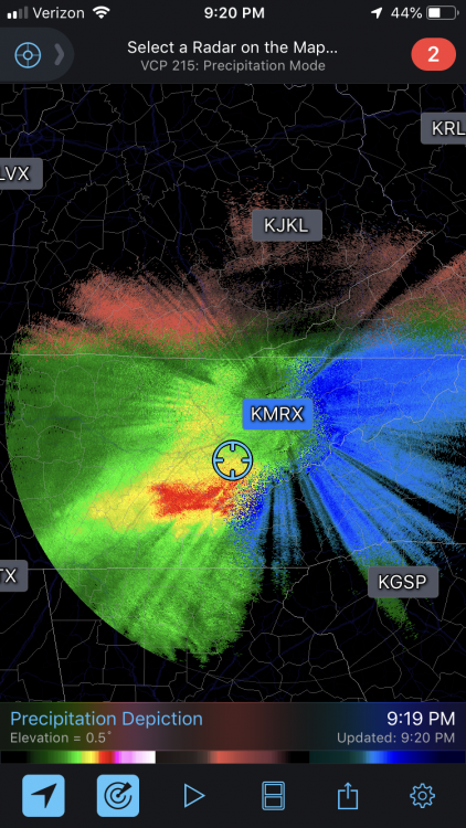
925-850 column is probably and finally cooling on that side of Clinch now like had down here in Bristol. Enjoy the show!I don't know how to say this but...It's back to snow by some miracle all in the short time span of 10 minutes! I don't know how, I don't know why, I don't know for how long but the downslope has toned it down some. Welp, I'm not forgetting this one. You see I didn't cliff dive I accepted my fate and said go on mock me. Instead in the most twisted way it mocked me in that it is now a pure heavy snowfall with some inch in diameter flakes. Of course in 15 mins I'm sure It'll be back to roasting anything frozen that dare falls here within a 5 mile radius. UPDATE: 2 minutes later it's back to a mix. xD
 -
32° and moderate snow. Only got an inch of accumulation so far but that is probably due to the initial sleet/graupel slush mix melting on the ground. Things are picking up now. Expect accumulations to build from this point forward.
-
Event is already underway but worth posting the 0z ECMWF totals before things get crazy:

-
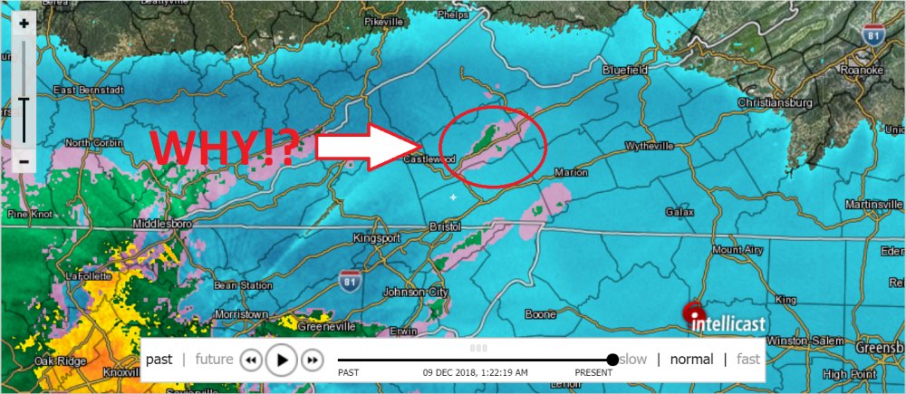
Downsloping off Clinch Mtn perhaps? There may also be downsloping off Holston Mtn, but I am far enough away that it isn't affecting me.I don't understand what is causing the warm pocket over me. I feel like I'm in the worst location for miles around. Every short range models shows me under freezing rain all night. I checked the hourly forecast for Honaker and then I checked the forecast for Lebanon just a hop and skip down the road (It shouldn't look that different). Here is Honaker's hourly forecast: https://weather.com/weather/hourbyhour/l/24260:4:US Here is Lebanon's forecast: https://weather.com/weather/hourbyhour/l/USVA0426:1:US The thing is things are looking a heck of a lot more like Lebanon right now. It doesn't seem to be related to a warmnose in the upper levels of the atmosphere but rather it seems to be a local phenomena caused by local factors that still affect the upper levels. If the radar is right everywhere else in the region is getting hammered. I thought I could dismiss this look on the High-res models but noooo.... I just can't seem to win. It's one thing to be stuck in the situation deep in the valley with expectation of this. It's another thing to be surrounded by heavy snow on an upper level heat island "screw over zone" in a generally positive climate relatively speaking. I wish I had or at least knew how to access products that would show the current temperatures at the upper levels. I'm taking a direct slap to the face. I hope, I HOPE I'm wrong with this but it's looking likely this is how things go. As for assigning a term for this as I believe I mentioned earlier is this the downslope? Good luck everyone else I'll enjoy my long stay in ZR hell. I haven't been this frustrated with the weather in a long time.
-
Yeah, keep in mind that it is still really early and I hadn't originally expected a full changeover to snow until around 3-4AM at my location. I've got a slushy accumulation on everything that isn't pavement. Sleet/graupel mix with flakes right now. We're no where near the meat of the event and I expect the column will continue to cool despite the nose. May be near, perhaps after dawn before TYS sees anything significant as far as snowfall. KTRI should be all snow well before then.
-
 1
1
-
-
Temp holding at 33° but getting a heavy sleet/graupel mix with flakes.
-
Same here. Surfaces starting to cover.33.4 here. It has dropped quickly. Moderate snow is falling. Stuff is like cement. Raised surfaces are turning white.-
 1
1
-
-
33° here now.
-
 1
1
-
-
Same here. This has started well before I expected. Heavy wet flakes. Oh boy...I have moderate, wet snow falling right now. It is slop city at the moment. Slushy accumulations on outdoor furniture.
-
 1
1
-
-
Light snow continues to fall with a little bit of sleet mixed. 37 now. I don't think we're going to see any rain at all now. All frozen at this point.
Edit: Make that 35° now. Temp is falling fast. I would still consider light snow but it has definitely picked up the pace. Game on...

-
 1
1
-
-
Sleet has changed to light snow. Temp is now 38°F. Can't say I ever remember it snowing, even if light, at 38°F.
-
I had a burst of heavy sleet for about five minutes and now it's light. Again, expected only light rain at this point, hence my comment that the column must be cooling fast. Hopefully this means we will miss a significant duration of freezing rain.Hopefully it holds. I mean its not overpowering by any means. I gave it another check. Looks like very light sleet, rain, and snow. You can hear it hit the leaves that are still in the trees. And yes, I have the last two trees on the EC that are slow to drop their leaves. LOL. -
-
3k NAM is insane. Heavy snow in bright echoes for a long time over KTRI. This is going to be a monster run.

-
 1
1
-
-
Still sitting at 40° for four straight hours near Bristol. Kind of surprised it hasn't dropped a little at least. I'm sure it will start falling once the precip picks up.
-
16 minutes ago, Carvers Gap said:This is the final run of the 18z GFS for NE TN folks before the event begins. Seven runs ago it had virtually nothing and has trended steadily to this....that is quite a difference. I did notice that the 18z RGEM finally stopped its consistent and probably unrealistic rocket trajectory of snowfall totals. It backed down just a hair, but very respectable totals.

Not only has it caved, look at how much better it resolves the vort at 850mb. The past few days it didn't even resolve 145dm. We essentially have stronger lift in the weakness over the Southern/Central Apps. That, and also the precip column should be a classic dynamic cooling event for heavy wet snow.

-
 2
2
-
 1
1
-
-
Edit: Moving this out of the main thread since I just realized we have this storm obs thread going. John, can you get the obs thread stickied?
I reached 41° about an hour ago. Now 40° with a light breeze. Expected high was 43° but that's basically static. Though I guess 2° difference does matter when it's all down hill from here. Idk, perhaps it doesn't matter when it will probably be snowing above 32° for most of the AM, hence the heavy ratio. Probably won't get below freezing until after dawn unless the rates are absurd and it drives down the air temperature in the column much faster.
-
I have increased my expectations for the total at my location south of Bristol near the Holston River. My original thinking was 4-6" inches, but these late runs so close to event have me convinced to go higher. I expect 5:1, then 8:1 ratios as the column cools, then perhaps 10:1 between 7-10AM. Thinking 7-10 inches of cement. I had thought some nose might reach us here, perhaps enhanced by some downsloping, but that may be a minimal effect versus rapid cooling of the column. We'll be lucky to keep power.
-
Latest ECMWF for posterity:

-
 1
1
-
 1
1
-
-
Just noticed that for KTRI. Of course, still early in meso land and subject to change, but .25 to .4 with significant heavy snow on top would be disgusting. Models were hinting/showing this last night and I want no part of it. As I said last night as well, hopefully initial rain will transition to sleet quickly and then that forcing turns all snow in short order and remains snow through conclusion of event by Monday AM.
-
18z 32k NAM resolved a much better defined 850 vort over N. AL/GA and 700 mb weakness up into Kentucky versus 12z. No surprise at greater forcing and crushing snowfall rates over ETN this round. You can follow the 304dm and 145dm contours respectively.


-
 2
2
-


.thumb.png.4b4d000dd12260014c9c20899498543d.png)

December 8-10 Storm Obs
in Tennessee Valley
Posted
I'm measuring 5 to 6 inches so far outside. 2 to 3" of that is probably from all the heavy sleet/graupel that fell pre dawn. Moderate snow at the moment with brief periods of heavy when a strong band comes through. Looking at radar, 10+ may be a real possibility now. Perhaps even a foot. Trees are bending down. Worried we will lose power.