

Windspeed
-
Posts
4,822 -
Joined
-
Last visited
Content Type
Profiles
Blogs
Forums
American Weather
Media Demo
Store
Gallery
Everything posted by Windspeed
-
Did we not work out something with Mexico with regard to potential threats? Granted, Polo likely avoids landfall, but it will pass close enough to cause problems (i.e. flooding).
-
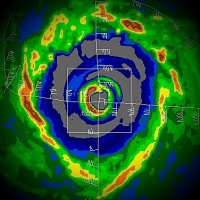
It is interesting to note that the official intensity estimate by the NHC is outpacing ADT numbers. Raw T# right now is 7.5 but it is important to note that dvorak doesn't always handle tiny eyes well within such an explosive CDO pattern such as this, and I am sure the met on duty that just upgraded Polo is well aware even if we won't get the discussion and explanation until the next package. That being said, numbers are skyrocketing up. Recon should be there by midday. I have little doubt Polo will be a Category 5 and an intense one at that.
-
Recon should be nailing Polo at or near peak. Also, I concur, no real trichoidal motion yet. The tiny eye is just moving with the subtle low-level westerly flow. There appears to be enough motion that the small eyewall should avoid significant upwelling prior to any internal structural change, which most likely will begin within 24 hours due to the very intense outter concetric banding structure that is developing. I can't see Polo not undergoing an EWRC outside of 24 hours given this appearance. I'll say recon finds an intense Category 5 hurricane of around 155 kts.
-

2026 Atlantic Hurricane Season
Windspeed replied to Stormchaserchuck1's topic in Tropical Headquarters
Haha, yeah, Fay just got decapitated. Oh well... -
2026 Atlantic Hurricane Season
Windspeed replied to Stormchaserchuck1's topic in Tropical Headquarters
Fay is perfectly located in a bubble of favorablility surrounded by chaos. If it's going to make a run at hurricane intensity, it needs to do it fast. It's going to get decapitated on Monday. How much strengthening it can do by tonight remains to be seen, but convection continues to blossom, and the small vortex looks nice and stacked with the low-level and mid-level circulations for now. Baroclinic enhancement combined with warm SSTs and a cold-pool aloft would support a short period of rapid intensification if encroaching shear and dry air can hold off until Monday morning. The limited potential is there to end the hurricane drought, but Fay needs to do its thing pretty much immediately. Being in the middle of nowhere without recon to sample and only ASCAT means we will literally need to see an eye form most likely to increase the odds of an upgrade. Being such a tiny vortex, remote sensing techniques might just as well miss / fail to detect any short-lived wind intensity estimate around its tiny core to support a Category 1. EDIT: I flirted with making a thread, but Fay is no threat to land and will dissipate within a few days. Other than the meteorological significance for the 2026 season, not much else discussion-wise would matter. We may as well just leave Fay's discussion in the main thread here for that purpose alone. -
2026 Atlantic Hurricane Season
Windspeed replied to Stormchaserchuck1's topic in Tropical Headquarters
99L's low-level circulation appears to be tightening up under the moderate convective canopy. There is clearly mid-level spin parked over the LLC now. This should end the named storm drought this morning. How strong it can get before environmental conditions deteriorate by Monday-Tuesday remains questionable. Though you can see the shear axis is positioned dangerously close, just south of the system, made evident by the screaming upper cirrus flow on satellite, I could easily see this topping out around 50-60 kts if it can remain just north if it. SSTs are warm enough, combined with a cold pool aloft, to continue supporting convection in the short term. -
2026 Atlantic Hurricane Season
Windspeed replied to Stormchaserchuck1's topic in Tropical Headquarters
It still does have a system / vorticity breaking off of the CAG 130'ish hours into the 6Z run, it just fails to develop a fully fledged TC and bring that into the GOM. That could just as easily come back on the 12z today. Again, chaotic. Though, yes, it also breaks off vorticity and develops a hurricane late in the run. Meh, these simulations will remain complete choas until something actually resolves. If anything can be taken from these runs at this point, it's to say we should have a warbling surface trough gyre establish itself by this weekend over central America and we just need to watch for any pieces of energy and vorticity that may break off on either side of the landmass (EPAC or WCARIB) for potential development over the next few weeks. -
2026 Atlantic Hurricane Season
Windspeed replied to Stormchaserchuck1's topic in Tropical Headquarters
Lol at tonight's GFS 00z operational. I made a post during the previous week that modeling of any potential CAG system was going to be rather chaotic until something actually resolved. That has definitely been the case. Still, if something develops and gets in the right position at the right time, potential exists for a powerful system given the potential favorable upper environment that should evolve over the GOM next week. If nothing else, it's something to watch. Mind you, though the UKMet and GFS suites continue flirting with a system, the Euro suites haven't been bothered yet. I should add it's not that Euro doesn't have the CAG there, it just transfers that energy or resulting vorticity into the EPAC instead of trying to resolve something in the WCARIB or GOM. -
2026 Atlantic Hurricane Season
Windspeed replied to Stormchaserchuck1's topic in Tropical Headquarters
I think the latest date ever recorded for the formation of a hurricane since maritime shipping logs occurred in 1941. That date is September 17th. That record is toast. -
2026 Atlantic Hurricane Season
Windspeed replied to Stormchaserchuck1's topic in Tropical Headquarters
Though I am certain many that frequent here as tropical enthusiasts and mets are bored stiff, I am not. Several, including vortex95 have mentioned the importance of a season like this for data acquisition, trends, and analogs for study and future reference. We aren't just setting a record now. We are shattering it. Clearly, we're in rare territory. With the shear values at record levels across the basin (the exception being pockets of favorablility over the GOM and SE CONUS), we're going to have to consider the potential of development remaining null and void over the MDR and central Atlantic basin persisting into closure of the season. Normally, we get a hybrid system that transitions into a fully symmetrical TC somewhere during October and November. But if the upper-level environment remains status quo, that may not occur this year. Really, the only potential could come from a CAG system during late September and October, but it's going to take some luck. I still do think we get a hurricane in the GOM or WCARIB, but we've only got two months to see that to fruition. Clearly, whatever is transpiring with this record-breaking El Niño is overwhelming whatever has anchored the extended +AMO decadal cycle and shut that down, at least for now. -
2026 Atlantic Hurricane Season
Windspeed replied to Stormchaserchuck1's topic in Tropical Headquarters
It's definitely among the most fascinating microcanes. Does anyone remember Iris? That's my all-time favorite. -
2026 Atlantic Hurricane Season
Windspeed replied to Stormchaserchuck1's topic in Tropical Headquarters
It's going to be some chaotic modeling with any potential WCARIB gyre until we actually get a gyre and low genesis. Best watch with huge clumps of salt. -
Burst of deep convection in the last thirty minutes. Hopefully, that doesn't wrap around because it is crunch time.
-
^Thanks for posting the Molokaʻi radar. You can still make out the eyewall and does indeed look like Ni'ihau is going to take a rough hit regardless now. Also, the closer 88D site in Kauai that failed/went down earlier is very exposed on the southern coast. So it would have probably failed at some point regardless of issue. https://bsky.app/profile/kc5knd.bsky.social/post/3muy33554uk2v
-
Most recent pass by recon:
-
The radar tower in Numila (PHKI) has been down for three hours. So we're running a bit blind beyond satellite. It's going to be very close whether the core or part of the eyewall clips Puuwai on the island of Ni'ihau. As mentioned before, modeling had us breathing too easy only to see guidance shift back east late in the game. I consider this a short-range failure in modeling, being that nearly all operationals and TC modeling had the core missing to the west somewhat comfortably no less than 48 hours ago. Again, you always hate to be on the eastern side of a chaotic trough interaction. Usually, if there are errors in a southwesterly steering flow setup, it's back towards the east if there is a correction.
-
2026 Atlantic Hurricane Season
Windspeed replied to Stormchaserchuck1's topic in Tropical Headquarters
The strengthening Azores SPHP is only going to exacerbate vertical shear with an increased low-level easterly jet as mid-to-upper westerly rivers are still firmly planted from central America across the Atlantic tropics, MDR and sub-tropics. That combined with SAL should get us to the new record on September 12th for the latest hurricane in the satellite era. Of course, we might extend that record for a while based on the look of long-range modeling. -
Modeling and the shorter range is coming together to miss Ni'ihau and Kauai to the west. The main official guidance is also locking in just far enough west to breathe easier. We still have to watch for any late adjustments back east to avoid impacts, but I feel a lot better about the core not impacting those two islands. Also, yes, the surf and wave action should be insane through the next week.
-
This is now on the short end of the midrange at no less than 120 hrs out now. Yet, it still should be tabbed with unusual uncertainty due to the lower accuracy of modeling a trough capture interaction. Yet, these are severe modeled impacts we have to watch. I must also be clear that the GFS has had its issues. Really, all global OPs have due to various lacking of data sampling. That being said, five days is, well, five days. We're creeping closer into short-range territory. Does this hold? I must admit I don't like this appearance. Any undermodeling of that trough and cutoff evolution, and we're even further east. Never like to be east of these when it comes to a southwesterly steering current.
-
The 18z ECMWF operational is more gradual with Lowell's northward turn and is slower with the capture of both Karina and eventually Lowell by the mid-to-upper trough. Lowell passes by at a further distance from Ni'ihau and Kauai before turning back towards the NW as the trough fills/weakens. The 00z GFS is much faster with Karina's capture, and the trough has a stronger influence on Lowell, impacting both islands. To be clear, at this range, both OPs are too close for comfort, and I am sure this is going to further fuel speculation tomorrow. Here is the 00z ECMWF. Still misses to the west, but it appears to be a closer pass than the 18z run:
-
Edouard isn't moving away from the juiced environment fast enough, and unfortunately, the mesoscales are showing deep intense training cells over the same locations this afternoon and evening. Some of these feeders may back'build towards the GOM. Flooding is going to become a big problem.
-
As mentioned in a previous post, we still need to watch that developing buzzsaw (Lowell) for a northward turn in a few days. Some of the globals have been flirting with Kauai every other operational run. It may ultimately miss to the west, but that may not be nailed down yet until we see how trough interaction evolves.
-
Edouard's structure remains quite impressive this late AM. It doesn't appear these deep convective bands are going to let up anytime soon. It's no surprise that the rain totals are beginning to lead to flash flood emergencies.
-
Storm totals so far with the worst falling between Warren and West Livingston. Storm motion is slowing, but the circulation is holding together quite well.
-
A discussion we can take over to the main seasonal thread, but I just wanted to state that the record shown by Dr. Klotzbach is definitely in jeopardy. To reiterate the point already made in above posts, given the rate at which Edouard was organizing over a mere 24 hours, I concur that it would have become a hurricane. Formation a bit further southeast over the east-central GOM, and it may have even bombed into a major prior to landfall. Granted, the environmental conditions weren't perfect. Lingering pockets of stable airmass in the mid-levels did appear to interfere with the convective envelope at times. But shear was light, and the immediate surface temperatures prime for rapid deepening once the system mixed that out. Location of genesis and the short window of time were ultimately the most critical factors in Edouard's development.


