

Windspeed
-
Posts
4,161 -
Joined
-
Last visited
Content Type
Profiles
Blogs
Forums
American Weather
Media Demo
Store
Gallery
Posts posted by Windspeed
-
-
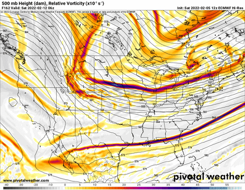
We're now within 100 hrs of modeling of a regional/forum wide Winter weather event. Probably a good time to go ahead and fire up a dedicated thread. For those wanting snow accumulations, good luck. This system does look decent on the majority of ops and ensembles right now in its positioning and timing for cold air to be in place. Totals on the other hand are still up in the air. We shall see how the week unfolds.
Latest GFS operational...

-
 4
4
-
-
Hrmmm...
-
4
-
 1
1
-
 2
2
-
-
Inject that straight into my veins. I'll gladly shut it down if that pans out.That was a beautiful Euro run, no doubt. Too bad it's the "new" Euro. But there is a signal across all ops for a storm that weekend.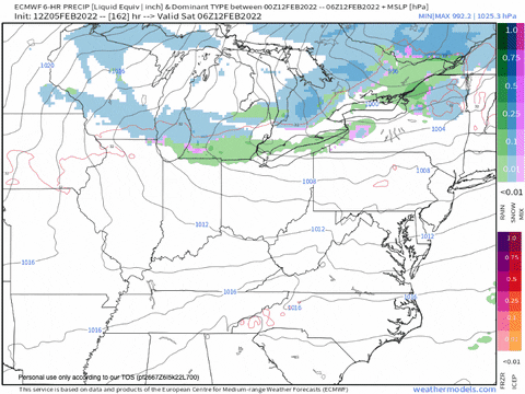

-
5
-
-
RE: Mesoscale, HRRR is really cranking a band over the eastern Valley and Appalachians. That could easily produce 1-3" accumulation with high rates of just a few hours. We're getting into crunch time.

-
4
-
-
Oh ye of little faith...This weekend sure went poof. Even for NW flow. Bleh.
IF we end up cold and snowless like the GFS more or less shows tonight it won't be long before I'll be hoping for spring and warmth.
-
7
-
-
There were some notable upstream changes in modeling today that are starting to play out with some westward shift. We likely do not have enough downstream blocking to lock in a significant inland shift, but even a further slight shift and readjustment over the coast on the 0z & 6z suites would significantly increase accumulation potential for the eastern Valley. Obviously Western-Central VA/NC and the Blue Ridge would end up the big winners. Just hoping we at least get some kind of accumulation along the I-75 and I-81 corridors beyond a dusting. There are apparently going to be some Gulf Stream flight datasets for a later time that could further change modeling suitesThe GFS was a massive shift west into North Carolina with the snow shield. I don't know if we can get another one like that, but if we did it would be a very nice event for East Tennessee even at lower elevations.tomorrow. Edit: Thursday. We shall see...-
2
-
-
-
Interesting take by Webb....
-
7
-
-
I was hopeful if at least a dusting this morning but the precip is sorta falling apart. Might see some flakes but meh..
-
Latest GFS operational looks good for the eastern Valley. The back end of the event for the Carolinas also jumped NW.

-
1
-
-
With this pattern in place, it'd be a real shame if the eastern Valley misses out on a good thumping. Looks good for now. We just need good low placement and colder temps to remain in place.
-
3
-
-
Snow is now ripping in Bristol, finally....
-
3
-
-
KTRI is within a dryslot right now with intermittent sunshine. Subsequently the temp came up a few degrees to 34°. Hoping as the upper low pivots south and southeast, precip will fill and a deformation band will form this evening. That should become all snow. Middle Tennessee is getting pounded right now. Congrats to them.
-
4
-
-
Haha yeah but we've already had some 1 and 2 inchers. I'll set the bar at 3" and be let down. lol..Man, I have set the bar at 1" of snow. LOL.-
 3
3
-
-
Usually I feel pretty good for KTRI versus the rest of the eastern Valley, even with an annoying 850 nose. But I honestly have no idea what to expect with this one. Obviously we're in a better location than areas southwest for MRX (Knoxville, Maryville, down to Chattanooga., etc.), if we can get rates to pump and negate that sloppy downslope potential. This system has a small chance to overperform for the eastern Valley like '96 if that 850 slows and digs further south than modeled. But it could also just not overcome the nose at all. So, again, I have no idea on this one. Uncomfortable to make a call. Too much sour modeling to get excited myself. I will say if we squeeze out anything more than 3+", it's a win.
-
9
-
-
Congrats to all that got snow. Especially the 4-7" variety. I might be just shy of 2" here south of Bristol. Not going to complain, it's pretty. But still waiting that 4-7" storm here though. Perhaps we get luckier in the coming weeks.
-
6
-
-
There is a nice band filling in SW to NE that should bring you some more, sir.Good pasting. About ~1" of snow. Will take. On the board for the season....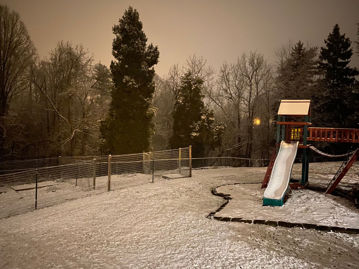
-
4
-
-
We've got some nice cloudcover right now over KTRI and 35° currently. Hoping the coverage can limit any significant temp gains. The high was forecast to reach 40°. But I don't think we'll make it. Also hopeful the 850 nose becomes quite limited. Anything to muster 3" totals for the event this evening. I am liking our chances.
-
3
-
-
Wow. That is newsworthy. He and his discussions will be greatly missed.Wasn't sure where to put this and there isn't really a place for it, but seeing as Stewart has been around since 1999 and is well known by those who read the discussions, I figured it was newsworthy enough to warrant its own (albeit small) thread.
https://www.nhc.noaa.gov/pdf/stewart_retirement_010122.pdf -
I would be ecstatic if this system could produce 3" for KTRI. Monday's system left a sour taste in my mouth. Models overdid the upper NE Valley regardless of the snow holes in the deformation band. But we're playing with much colder air this go around with entirely different flow aloft.
-
5
-
-
The last flake has fallen here. I think it is safe to say that this system underperformed for KTRI. I was thinking 3-4" in line with modeling and the MRX forecast, but I'll take my inch of cement and enjoy my day off. Congrats to those that scored. Hopefully this is just a tease for something better in the coming weeks.

-
4
-
-
South of Bristol, got stuck between two heavier bands just to our west and east for a while as the deformation pivoted. Though it is still snowing, I doubt we'll total 2" of accumulation. Still nice to finally get some decent snow so not going to complain at all.
Much of SWVA, including the valleys are in the sweet spot of that deformation band. Wytheville, Blacksburg, Pearisburg, Roanoke, etc., are getting hammered.-
1
-
-
MRX posted a video of that event. But I wish they would have noted that the surface temperatures had little impact on initial accumulation. It came down hard and fast and everything was covered within the first hour.
Very similar to Christmas Eve last year. Rates overcame ground temps quickly.
-
2
-
-
Starting to get excited. 2"/hr rates is no joke. If that heavy deformation band sets up, even if the strongest of the event only last 3-5 hours, that's a nice haul for NETN/SWVA. 4-6" for the upper northeast Valley seems possible with the higher elevations getting thumped. 8-12" looks doable for the Smokies, Banner Elk, Mt. Rogers, into the Blue Ridge.
-
1
-
March 11th-13th Winter Weather Event. Winter's last gasp?
in Tennessee Valley
Posted
Two days of modeling and many noticeable precipitation holes over KTRI not to go ahead and expect that. Hopefully even if that occurs, there's enough mustard in this system to squeeze out 2-3 inches.