-
Posts
4,161 -
Joined
-
Last visited
Content Type
Profiles
Blogs
Forums
American Weather
Media Demo
Store
Gallery
Posts posted by Windspeed
-
-
Yeah it may be a "half'cane", but the northern band that is dragging the shoreline is brutal. Hopefully this gets punched hard by westerly 400-300 hPa flow to shear off that northern eyewall before it reaches the Galveston area.Clear evidence of a hurricane at the mouth of Matagorda Bay. Elevation 7m. Assuming they see this observation, they'll upgrade.
-
-
About as clear a reformation as you're ever going to see and neat to have it visualized on quality radar. Interestingly, though shear is negative on the vortex due to tilt, in this case it will have bought Nicholas more time over water since the LLC that formed last night was very near to landfall. The new LLC forming under or closer to the MLC is going to be further NE. Still a sheared system though. The anticyclone is too far south of Nicholas. Whether a strong TS or minimal hurricane, this is still all about the heavy rain and flooding potential.Convection that had temporarily tried to become a formative core looks like it was sheared away from lllc, which may actually be reforming to the East. There’s clearly a strong MLC well to the northeast of the LLC, and this is becoming even more apparent on radar. May have to watch here for another center reformation. Pretty awesome process to watch on radar as the convection quite literally seems to be trying to drag the llc with it-
 1
1
-
-
Looking for if/when it can develop a core. If a core does develop with enough lead time prior to land interaction or an increase in westerly 300 hPa flow, then we have a shot at getting Hurricane Nicholas. If the system struggles to develop a core, then it likely follows forecast guidance for intensity closely. That's the uncertainty that the TC models will struggle with, with respect to intensity, for at least the next 24 hours.
-
 3
3
-
-
Larry still looks impressive on satellite. I thought it would look more devoid of cold cloudtops over the core at this point. Labrador province may actually see hurricane force winds. Especially given the fast forward motion + winds still mixing down via convective bands.

-
Larry has gained significant speed in forward motion. The core has moved over the cool Labrador Current, however, interaction with the strong mid-to-upper trough, baroclinic forcing and cooler upper tropospheric temperatures are allowing convection to persist. Larry may not weaken below hurricane intensity prior to landfall. Really, the core doesn't look that bad at all given extra-tropical transition has begun.

-
 1
1
-
-
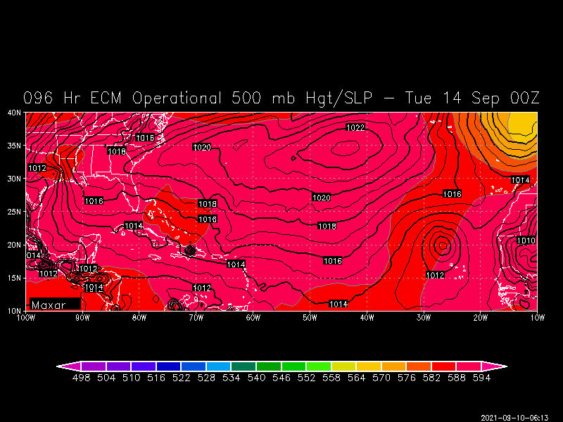
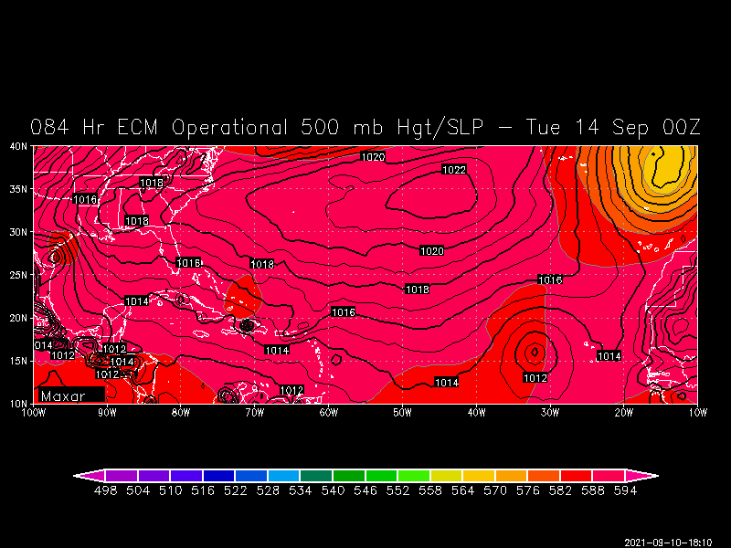
Yes, it's a pretty significant change into the midrange. It's just one operational run but there has definitely been a trend for something organizing and steered west across the MDR. The modeled pattern does not support a recurve so whatever would hypothetically develop would have to be watched for the Caribbean and Western Atlantic. You can see this clearly with stronger WAR 500 dm heights extending over the SECONUS.So, now the 12Z Euro fully gives in to the GFS and is no longer recurving it in the E Atlantic! Check out the huge difference vs 0Z:
0Z Euro still recurved it early:
The 12Z Euro says forget the early recurve, I'm going to do what the GFS has been doing from the start! On the 12Z run, it has it at 16N, 32W, vs 20N, 27W, on the 0Z run meaning 425 miles to the SW:

-
 2
2
-
-
-
Definitely going to be their worst hit since Odile. Of course Odile was a Category 4. But this will still pack quite a punch being a strengthening cyclone. Interesting to see what Josh samples.

-
Olafs' eyewall looks to be intensifying right into landfall here. Cabo San Lucas is definitely in for a wild night / morning.

-
 1
1
-
-
Hurricane Olaf has developed the dreaded pinehole eye and is forecast by the NHC to get dangerously close to Cabo San Lucas tomorrow. Hope this does not rapidly intensify prior to any land interaction there.

-
 1
1
-
-
Agreed. My post is intended to give a ceiling for any potential reintensification. It would still be tough for Larry to regain major hurricane status given its broad windfield. Most likely it may just become more efficient at mixing down winds to remain a hurricane. Perhaps regain Category 2 intensity at best. Current maximum winds on the 11AM AST advisory is 90 mph sustained.Seems typically with a large, tilted, fast moving system you tend to see more wind field expansion than an increase in max winds. But I suppose possible the eyewall could reorganize somewhat-
 1
1
-
-
Are those your tweets? I've interacted with your tweets a few times over the years. "yconsor", "jconsor", I suppose that didn't require much detective work there. lol..
At any rate, Larry is looking better on satellite today, even improved in a way that an eyewall may be rebuilding. Recon should be interesting. If a strong eyewall exists, those 100+ kt 850 hPa winds may start mixing down better.
Additionally, Larry still has several days to traverse sufficiently warm SSTs for reintensification given that it will be moving at a quicker pace. Shallow OHC, even at 27°C will support sufficient lapse rates in a large hurricane if it is moving fast enough and has adequate baroclinic support, which it looks like Larry will be given excellent support. Think Lorenzo in 2019. It was large and yet with excellent atmospheric dynamics pulled off Cat 5 intensity with shallow ~27°C SSTs. Larry has a larger/broader circulation than Lorenzo however, so I do not think it could pull off high end intensity of Category 4, but it certainly could tighten the gradient enough to regain major hurricane status.
-
 2
2
-
-
Not mid-level shear though. This is favorable upper level divergent shear in the exit region of a digging upper trough. Just saying it wasn't in an unfavorable location for continued strengthening.Doubt it given the southerly shear but it certainly could’ve been a 50 kt tropical storm in the next 6-10 hours. Very impressive structure on radar for a weak ts, even trying to wrap some bands upshear
-
 3
3
-
-
Larry's size is now what is impressive here. Yeah, yadda yadda Cat 5 stuff. But this is a true beastly maritime cyclone, period. Ridiculous long period wave heights being generated by this monster. This is the stuff of nightmares for shipping interests.

-
The small low-level vorticity maximum that developed is what got this going. Given another day or two, yadda yadda, would have probably been a hurricane.Particularly for the propensity to strengthen at landfall that's been the theme the last couple of years! -
Just edit your original post for the thread and change the title.Sorry, I don't know how to change its name... how do you?-
 1
1
-
-
@SnowenOutThere If you start a tropical thread, you own it and keep it updated.

-
 2
2
-
 1
1
-
-
-
-
Looks like TS Mindy.It will be TD13 for the 5pm advisory.
https://www.nhc.noaa.gov/text/refresh/MIATCPAT3+shtml/DDHHMM.shtml-
 1
1
-
-
-
-
Just satellite estimates. Unsure if the Japan-based recon project from several years ago is still a thing. ADT unfortunately isn't the best with small 'canes/typhoons that have pinehole eyes. Hence 945 mb / 115 kts at present via latest estimates. JTWC notes this issue in its prognostic reasoning:Surprised this is only at 140kts. Hard for me to believe such an incredible sat presentation along with a cleared out 5 mile wide pinhole eye is only producing 140kts.
Anyone know the pressure on this thing?SATELLITE ANALYSIS, INITIAL POSITION AND INTENSITY DISCUSSION: ANIMATED MULTISPECTRAL SATELLITE IMAGERY (MSI) INDICATES THAT SUPER TYPHOON CHANTHU HAS CONTINUED TO INTENSIFY OVER THE PAST SIX HOURS, WITH A VERY COMPACT CORE OF INTENSE CONVECTION WRAPPING INTO A 5NM PINHOLE EYE. THERE IS HIGH CONFIDENCE IN THE INITIAL POSITION BASED ON THE PINHOLE EYE AND AN EXTRAPOLATION OF A 080433Z AMSR2 89GHZ MICROWAVE IMAGE WHICH SHOWED THE PINHOLE EYE SURROUNDED BY A CORE OF INTENSE CONVECTION AS WELL A MOAT REGION AND ANOTHER BAND OF STRONG CONVECTION WHICH IS LIKELY THE FIRST SIGN OF A DEVELOPING SECONDARY EYEWALL. AN EYEWALL REPLACEMENT CYCLE (EWRC) IS EXPECTED TO BEGIN IMMINENTLY. OBJECTIVE DVORAK ESTIMATES ARE STRUGGLING TO PROPERLY ASSESS THE INTENSITY OF STY 19W DUE TO EXTREMELY SMALL EYE, THE ADT AT TIMES SWITCHING TO EMBEDDED CENTER TECHNIQUE AS IT STRUGGLES TO MAINTAIN TRACK ON THE EYE. SUBJECTIVE ESTIMATES ARE ALSO STRUGGLING TO PROVIDE CONSISTENT AND ACCURATE INTENSITY ESTIMATES, AS THE RESOLUTION OF AVAILABLE INFRARED IMAGERY IS SUCH THAT THE EYE TEMPERATURE MEASUREMENTS ARE SHOWING WILD SWINGS FROM AS HIGH AS 16C TO AS LOW AS -48C. ADDITIONALLY, A STRONG INNER-CORE LIGHTNING BURST WAS OBSERVED BETWEEN 0200Z AND 0600Z, WHICH COULD ALSO SUPPORT A PERIOD OF INTENSIFICATION LEADING UP TO THE 0600Z INTENSITY. THE INITIAL INTENSITY HAS BEEN INCREASED TO 140 KNOTS BASED PRIMARILY ON AN EXTRAPOLATION OF AN UNOFFICIAL INTENSITY ESTIMATE OF T7.0 OBTAINED AT 0310Z USING THE ADT EYE TEMP OF 16C AND COMPARING THE OVERALL STRUCTURE AT THAT TIME TO THE STRUCTURE AT 0600Z, WHICH HAD DEPICTED AN EVEN SMALLER EYE AND COLDER CLOUD TEMPERATURES, THE LIGHTNING BURST AND ASSESSMENT OF THE AMSR2 MICROWAVE DATA. THUS THE LOW CONFIDENCE INTENSITY IS WELL ABOVE ALL AVAILABLE FIX ESTIMATES. STY 19W IS TRACKING WEST-SOUTHWEST IN A HIGHLY FAVORABLE ENVIRONMENT OF LOW NORTHERLY VWS, GOOD RADIAL OUTFLOW AND WARM SST, HIGH OHC WATERS.


Hurricane Nicholas
in Tropical Headquarters
Posted