-
Posts
4,161 -
Joined
-
Last visited
Content Type
Profiles
Blogs
Forums
American Weather
Media Demo
Store
Gallery
Posts posted by Windspeed
-
-
We're not in Storm Mode. If it relates to Sam and is anything meteorological like the question you pose, then just take this to the Sam thread.Since I do not see a banter thread for Sam I will ask this here.
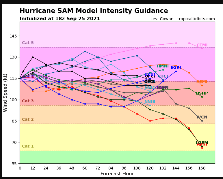
What are the chances that Sam will make it to a Cat 5? At first I thought it would reach it, but the models don't seem to get it to be that powerful. But they also seem to be underperforming what is actually going on with Sam.

-
 1
1
-
-
3 hours ago, Prospero said:"Teresa" had to have a storm this year. (My mother-in-laws name).
I say better a minimal Tropical Storm out at sea than a Major anywhere. Seriously!
You think that's bad? My late grandmother's name was Ida. My father's name is Sam.

-
 1
1
-
-
lol at that 921 mb wind. I suppose if the pressure falls any further or the wind / pressure gradiant had a little more time before any structural degradation of the eyewall, it might pull off Cat 5.
Sam is a compact hurricane. I suppose we'll just have to see how long the core can maintain this structure without concentric banding getting the upper hand. Irma was pretty resilient to full cycle ERCs in this region back in 2017. It would pull off some some kind of absorption of the outer band before it could fully become concentric.-
 1
1
-
-
I'm a little leary of >140 kt SFMR readings without similiar flight level readings as well. But Sam is no doubt an intense hurricane. Especially in this region of the MDR. It's in rare company. Think Hugo and Irma. I'd be comfortable with 135 kts / 155 mph on the next advisory.Don't see the FL winds to support it in this set of data, but there's an unflagged 141kt SFMR on this latest pass (SE to NW).-
 1
1
-
-
I'm not even sure why I typed CGs ( i.e cloud-to-ground). I wasn't even thinking CGs when I made the post. But, yes, just GLM remote sensing data.It's just flashes. The GLM is an optical instrument. Doesn't know what type of lightning. -
Tidbits is back up for the moment. NOAA2 (Miss Piggy) is the current recon mission into Sam. There are also active data gathering missions to sample the atmospheric environment for the overnight model suites.
-
 1
1
-
-
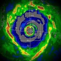
Lightning CGs.What are the white dots in and around the eye?
-
 1
1
-
-
Sam has most likely attained Category 4 intensity. Good time for recon to be en route. I suspect that is what they'll find.

-
 4
4
-
-
Uh oh..

-
A reality of improving remote sensing technology and analysis. The science remains the same. If data supports classification, the argument is moot. There isn't an underlying agenda. As has been repeated nearly every time such discussion comes up in a thread, TAFB is responsible for maritime shipping interests, not just coastal threats. If data supports classification or naming and poses potential risk, a forecaster has to make a call. Nothing is perfect but it's their judgements and they have a huge responsibility, so why clutter up these threads with the same old points? Accept it, they're going to do their jobs, move on...But even then we've had recent storms attain hurricane status that in years past never would have. -
I. ATLANTIC REQUIREMENTSAnyone know when recon plans to fly in?
1. HURRICANE SAM FLIGHT ONE - NOAA 43 A. 26/1200Z B. NOAA3 0118A SAM C. 26/0800Z D. 13.1N 49.7W E. 26/1045Z TO 26/1345Z F. SFC TO 10,000 FT
2. OUTLOOK FOR SUCCEEDING DAY: A. AN AIR FORCE WC-130J FIX MISSION INTO SAM FOR 27/1130Z NEAR 14.6N 52.1W B. A NOAA 49 SYNOPTIC SURVEILLANCE MISSION AROUND SAM FOR THE 27/0000Z SYNOPTIC TIME, DEPARTING TISX AT 26/1730Z. C. TWO MORE NOAA P-3 TAIL DOPPLER RADAR MISSIONS INTO SAM, DEPARTING TISX AT 26/2000Z AND 27/0800Z
3. REMARKS: A. THE NOAA 49 G-IV WILL FLY AN 8-HOUR RESEARCH MISSION AROUND SAM, DEPARTING TISX AT 25/1830Z B. THE NOAA 42 P-3 WILL FLY AN 8.5-HOUR RESEARCH MISSION INTO SAM, DEPARTING TISX AT 25/1900Z
-
 3
3
-
-
Hey no need to take meteorological discussion personal. Yes, the majority of MDR solutions are OTS by the nature of distance and wave perturbations. It is what it is...
That being said, we're looking for any potential way Sam could impact the ECONUS because that's what makes the discussion interesting. When people proclaim a landfall is going to happen at this range, that is essentially wishcasting. Likewise, to say there's no way this makes ECONUS landfall is also premature. We are getting into the midrange in time period for our steering features so we can start saying something is unlikely. I have no issue with that. I mean, landfall is unlikely. Here is the big caveat though. We have a big wrinkle in the buildup stuck in the downstream pattern that the models are still ironing out even into the midrange. How does the cutoff trough feature evolve and how close does Sam get within juxtaposition. If that trough retrogrades SW, then we significantly increase the chances of a landfall, and not just Nova Scotia strong either. OTOH, If the cutoff sticks around over the coastal region/eastern Carolinas, then the door for US landfall closes shut.
Simply put, it's going to take another 48 hrs of modeling to know for certain whether Sam is OTS (beyond Bermuda) or a potential threat. No need to get dramatic about that.-
 8
8
-
-
28.5-29°C SSTs, negligible shear, has a core per MW, CBs rotating that eyewall feature; all signs point to Sam reaching hurricane status in the AM if at least by Noon AST. No wonder the SHIPs is so pronounced for an RI phase. Only we appear to already be ahead of schedule by 24 hours. Sam will be a classic Cape Verde major hurricane by Saturday, if not sooner.


-
 3
3
-
-
We have Sam. Let the Dr. Seuss'ing begin.

-
 1
1
-
 3
3
-
-
OTS is not in stone and too far out. You still have a potential maritime block over New Foundland with a cutoff trough over the ECONUS. Can't rule out phase interaction with trough until we're in the midrange. Writing off to OTS at 220-240 hrs is... premature.
At least allow interaction time to move into the midrange to provide better timing and positional placement of features.-
 5
5
-
-
The ECMWF is obviously catching everyone's eye here. It's important to remember that placement of ECONUS trough vs WAR with regards to land interaction beyond the Antilles is still beyond the midrange and clearly subject to change. That being said, if the door shuts for potential Sam around 150 hrs to escape poleward, then there is the potential for some type of phase interaction setup that would come into play. This would be dependent on amplification of the WAR and position/timing of Sam. This type of pattern isn't one of a recurve but of a TC being captured and driven very quickly into the high latitudes around the stationary mid-trough parked into the ECONUS interior. Again, way too far out only to speculate, but there it is... The strong block over ECAN is heading downstream towards New Foundland, which would spell trouble.

-
 3
3
-
 1
1
-
-
Jim Edds' Haiyan video should be right up there with the aforementioned. He was submerged in a pool inside the eyewall.That, Josh’s video from Dorian, and that Mexico Beach video from the condo during Michael are the 3 most intense hurricane videos I know-
 2
2
-
-
I think it is becoming pretty obvious here that the inner eyewall of Ida was very intense and clearly upper Cat 4 intensity. Was it as intense as Michael? No. But this particular gust was definitely supportive of 150+ sustained at the surface. It is really just a matter of luck that Ida's inner eyewall did not strike a populated community at landfall.
-
 4
4
-
-
-
I think some of this is due to regardless of MJO phase placement or status of the WAM, when there is a pronounced -AMO, it tends to keep CV long-trackers somewhat in check. There is a balance though. All it takes is for a subtle swing to +AMO or similar cooling of the upper-central Atlantic pool to kick in more MDR favorability. We may see something close over the next month.I think it's time to strip the central Atlantic of the MDR name and give it to the western Caribbean/southern Gulf. That's the new Main Development Region.
Additonally, there should still be a robust wave train coming off Africa late into October at least. So again, as has been the recent trend over the last half-decade, we may see a loaded back end to the season.
A couple of interesting tweets that suggest such potential:-
 2
2
-
-
Way too much uncertainty. The models are iffy on how the pattern amplifies down stream with respect to 96L. When that system lifts out, the remaining upper PV could easily get squashed depending on timing and intensity of 95L leaving it behind with an ECONUS ridge to build heights over the WATL. I do not think we'll have a good idea of potential long-term track until we get into the midrange here. The resulting TC from 95L could be anywhere from Bermuda to Jamaica. It's really just a guessing game at this point.
-
 3
3
-
-
Ugh..
-
Center of the LLC keeps sliding parallel to coast, even if temporary. Fascinating how intense convective updrafts can bend and slip/jump the vortex down shear. But if the updraft within the eye band relaxes the slightest, it may succumb to upper horizontal flow and shear off, resulting in low-to-mid level steering flow regaining motion. Perhaps just enough motion to finally get the vortex inland.

-
You're calling me out for meteorological discussion. Piss off.Nobody tracks these to watch fizzling TS landfall. You’re basically concern trolling.-
 1
1
-


Major Hurricane Sam
in Tropical Headquarters
Posted