

Windspeed
-
Posts
4,159 -
Joined
-
Last visited
Content Type
Profiles
Blogs
Forums
American Weather
Media Demo
Store
Gallery
Posts posted by Windspeed
-
-
That may be cloud debris from the old eyewall left by the earlier ERC or partial cycle rotating around.Eye looks to have collapsed again...
Sent from my SM-S102DL using Tapatalk -
Recon found pressures have fallen to around 933'ish but the winds have not increased. In fact they have dropped. This may be due to new strengthening eyewall convection but perhaps the vortex has not yet spun up to respond to the pressure falls.
-
-
I think forward motion to the north is gaining just enough to finally ease the 300 mb flow, though it had already eased on the core somewhat the past 24 hrs, which allowed Fiona to become a Cat 4. There are some strong outer banding features, so cannot rule out multiple ERCs during the next few days, but Fiona may not have peaked yet if a stable eye can take advantage of the ever improving upper environment.
-
Forward motion matters with respect to the Pandhandle and shelf waters as well. Sure, if the potential TC is intense but gets left behind prior to landfall, it would stall, upwell itself plus entrain continental airmass. However, if it remains at a decent northerly forward motion into the panhandle, shelf waters are still currently running hot. There has yet to be a significant cold front pass through or at least one to bring down SSTs. So the shallow shelf would be more than sufficient to fuel a Cat 5 just like Michael or Camille. Of course, a hook to the right, 300mb flow, trough ventilation, structure, trough bypass, all speculation for a week or more and we don't even have a TC yet.If you want a strong landfall you want this to get pulled up ahead of the trough and moving briskly in a NE direction into landfall so it’s going with the shear vector. You also don’t want a system going into the big bend area of Florida where there is extensive shelf water. A Charley like track would yield your strongest LF, in the situation as modeled. If this gets left behind the trough, it will be encircled in dry stable air, moving slower over shelf waters, and subject to NW shear. That’s why the GFS is showing rapid weakening.
It is FAR too early to discuss these specifics. The storm isn’t even formed yet and the trough interaction is long range. My gut says whatever forms will end up further east, maybe Euro type track, as that has been the trend this year for models to go too far west then correct east, especially with unusually low heights on the east coast. Let’s monitor cyclone formation before nitpicking intensity at long range. Happy tracking.-
 6
6
-
-
Discussion of 98L becoming Hurricane Hermine are bit premature. The AEW/AOI in the eastern MDR is gaining support for development. It's quite possible 98L will be slower to go through TCG until the central Carribean versus the AEW in the visible imagery that is a more concentrated surface low right now. The MDR AOI doesn't even have an invest tag yet, but it may not be long today. The Caribbean system could be the dreaded "I" storm. Though of course that's all poppycock superstitious hogwash.

-
3
-
-
This map is blowing my mind. I get the extreme high latitude in association with the Gulf Stream current for catagorical cyclone intensity potential. But the upper portion of the map seems impossible, as though those SSTs are running above normal, they're still very cold and way below the threshold to support a tropical surface low.
-
Pressure continues to fall but Fiona's slow forward motion is allowing the 300 mb flow to impede it somewhat keeping it in check. The double wind maxima is perhaps telling that it won't resolve these structural issues until it gains faster northerly forward motion, which should allow it to take off intensity wise.
-
2
-
-
This is actually easier to see via AVN as you can better make out the -80C/coldest tops. Notice all the GLM lightning detections with each convective burst/tower going up around the northern eyewall to reach highest altitude in the western to southwestern semicircle. These towers are rotating into the 300 mb flow and some of the canopy is overshooting the eye. That being said, the intense convection is likely dropping pressure and increasing the gradient. Fiona is intensifying.Hot towers are firing against the 300 mb flow. It's a light shear essentially, so mid-level cloud debris is sinking into the eye. The positive ventilation to the north is outpacing the negative counter vector flow from the southwest. I'd call this favorable for a strengthening major hurricane, but perhaps not a perfect envelope until the hurricane turns more northerly. All in all, a period of RI tonight or in the morning remains quite possible.
-
5
-
-
Hot towers are firing against the 300 mb flow. It's a light shear essentially, so mid-level cloud debris is sinking into the eye. The positive ventilation to the north is outpacing the negative counter vector flow from the southwest. I'd call this favorable for a strengthening major hurricane, but perhaps not a perfect envelope until the hurricane turns more northerly. All in all, a period of RI tonight or in the morning remains quite possible.Satellite appearance, specifically the eye, has degraded somewhat since earlier with a contracting eye, but could be due to towers maybe? Maybe EWRC but not much evidence of a secondary eyewall. Recon about to pass through so we'll see if it's steady or intensifying still.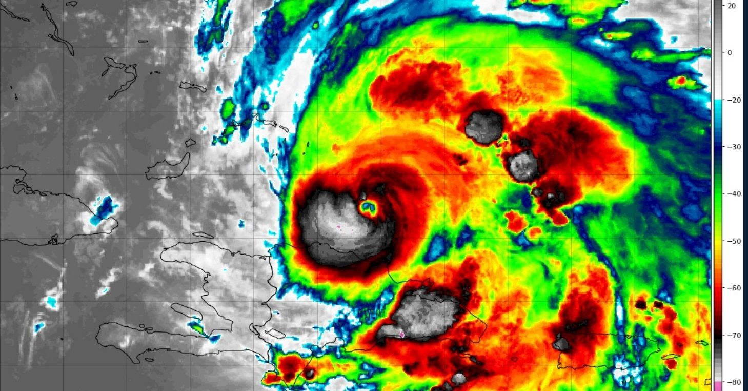
-
4
-
 1
1
-
-
^Nope, it sure isn't...

-
3
-
-
Well we need the AEW to spawn a surface low before I get too excited, but obviously if we do see genesis out of this, the modeled potential is worth the superlatives. It appears the Atlantic got tired of the whining and woke up. If this and a few other systems pan out, we should push ahead of normal climatological ACE into an active season. But unless the Caribbean goes bonkers in October, I am pretty confident we won't eek out a hyperactive season at this point.
Here a nice tweet describing the setup for the potential future TC into the Caribbean.
-
2
-
-
I thought there would be some lag time post exit of landmass for reintensification. Perhaps atleast 6-10 hours of ocean time. I mean this was a trek over the DR, even if the core remained over the lowlands. But I was considering the mountainous terrain impeding some of its low-level inflow into the core. Uhhh... that appears to be a big negatory, slappy. Fiona looks like it is about to experience some explosive deepening.
-
2
-
 1
1
-
-
-
Three day totals up to 20" near Ponce.

-
-
When modeling consensus and ensembles miss the mark, it just is what it is. Goes to show that tropical surface lows are still sometimes tough to nail even in the shorterm.18z yesterday run.
This is pretty damn bad, especially how tight the clustering is, lending high confidence to any meteorologist focused on this output.

-
3
-
-
Ongoing onslaught of the back feeder bands continue. Daytime heating and instability may unfortunately increase low-level convective feed/fetch, so this sadly looks to continue throughout the day until Fiona can gain some distance. No way to paint the situation but dire at this point.

-
 1
1
-
-
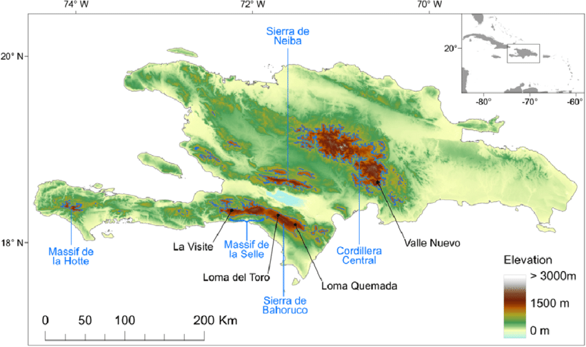
Agreed. I think most had expected a more northerly component to the WNW motion by this point. It's still drifting west of guidance, if subtle, having implications to shorterm intensification tonight when it clears the DR landmass. Low level inflow will be hindered more if it cannot gain some latitude. So a gradual decline intensity until it is east of Turks and Caicos seems logical now.Fiona having significant land interaction with Hispaniola—something that all major guidance missed 24 hrs ago. The impending dissipation now means higher than usual short term uncertainty on track.
Just the proximity of the 6,000 ft + mountains over central Hispaniola will do much to disrupt the mesoscale vectors funneling into Fiona’s surface circulation over next 6-10 hrs. Bold forecast to have this as a hurricane in 12 hrs. I think 75/25 we see downgrade to TS before re-emerging.
-
This is a good distance away from the NOAA radar tower in PR, so the returns from the beam are weak, but you can still easily make out the eye. Punta Cana was very likely near or in the northern eyewall this morning. They're now in the back/behind the right-front quadrant as Fiona is moving away. Fiona's structure is pretty amazing right now considering the core is entirely over land. Though this part of DR is lowlands and the outer circulation is still getting feed off the Carribean. Impressive, still.Punta cana in is for a world of hurt with a strengthening hurricane
-
If not for the close proximity of mountainous terrain and land interaction in general, Fiona would be closing in on major hurricane intensity tonight. This is no longer the appearance of a struggling hurricane. Outflow is excellent. Towers firing in the eyewall. It likely will not do anything too crazy since it will crossing over NE DR, but it certainly looks like Fiona will eventually become an intense hurricane near to or just east of the Turks and Caicos tomorrow. Perhaps a bit of recovery time depending on how long it takes to clear DR. But the atmospheric envelope looks primed.

-
3
-
 1
1
-
-
-
That beast trough is so strong it may very well capture and phase Fiona into New Foundland, perhaps even Nova Scotia. Good take is that though Fiona may get intense, it may miss Bermuda cleanly to the west.

-
1
-
-
Most recent radar derived estimate...Does anybody know the rain totals coming out of Puerto Rico
-
3
-

Major Hurricane Fiona
in Tropical Headquarters
Posted
Yeah I am pretty certain that is old wall cloud debris slowly dissipating. Fiona is looking pretty sexy right now. Wonder what peak will end up being. I'm going to say 145 mph sustained sometime during the day tomorrow, though certainly it could get there tonight.
