

Windspeed
-
Posts
4,613 -
Joined
-
Last visited
Content Type
Profiles
Blogs
Forums
American Weather
Media Demo
Store
Gallery
Posts posted by Windspeed
-
-
Someone earlier in the thread mentioned Elena. Interestingly, these patterned loops are popping up on several repeated runs of the global OPs. If this disturbance does wind up in the EGOM and does a loop over water instead of the Peninsula, it could open the door for some rather dramatic intensification and forecasting chaos for the coastline. It's a mitigating nightmare for evacuations. I've always wondered what another Elena would be like in recent years. At any rate, it's only worth mentioning due to that potential loop. I am certainly not suggesting that will occur. The loop or stall might occur over land. Or it might just be incorrectly modeled within the pattern this far out, and no stall or loop even resolves if a hypothetical TC even reaches that far west.
-
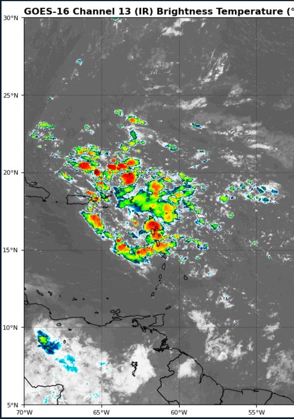
Convection is finally starting to bubble. I think the thing to watch here is where does it start to condense? Euro has consistently been showing the center to stay well north of the islands while GFS has consistently been showing the center going straight through the islands. Looking at this picture, I think the GFS may be correct...

I know you didn't intend in your post that we already have a center, so I am just going to clarify here in my words for everyone else to understand. Keep in mind that we do not have a center yet. Based on satellite observation and TAFB surface analysis, the yet to be labeled invest is merely a broad tropical wave (the axis of which is cutting through the NE Leewards). Bubbling of convection has been occurring along the boundary where the moist fetch is established out of the ITCZ. However, strong convection is now beginning to consolidate within the northern wave axis. You may see this now in the IR animation I am including in this reply. Now that we have an envelope of convection, we'll have to closely watch where the most intense CBs get going. If that gains consistency in the northern axis, our disturbance may begin to fold north of the GA. Also, just because strong convection takes off this evening, the process may still take a few days to consolidate into a tighter surface low and vorticity maximum. But it is important to note that we have convection in the northern periphery of the tropical wave. So, the potential remains for either model suite to win out here on when and where TCG occurs. It might still be over the Antilles or it could be in more of a heading towards the Bahamas as the ECMWF OPs and EPS ensembles have repeatedly suggested.
Again, this wave is still broad. It's going to take some time for convection to concentrate and tighten this disturbance into a potential TC. I am still leaning towards the EPS, especially now that CBs are blossoming in the northern axis, and that looks more intense than the spotty stuff down in the NE Leewards.
Regardless of TCG, when and where, it really is something how modeling has flirted with the development of this behometh of a tropical wave that's spent the better part of a week devoid of convection. Precipitable water anomalies (PWATa) were always there near the 950-700 hPa level, the system just needed enough time for SAL-induced dry mid-levels to moderate with the attached southerly backside connection to the ITCZ and increasing lapse rate potential due to bathwater SSTs in the western MDR.
I do think this disturbance becomes a TC in 2-3 days. I still think it's too early to know if we'll see an ECONUS hit. We need to see how fast genesis occurs and how much initial latitude is gained versus the weakness that will open a door for poleward recurve. Everything is still on the table from EGOM to Carolinas to OTS.
-
 4
4
-
 1
1
-
-
If the Euro storm does develop, it will be developing before favorable upward motion gets to the Atlantic. That would indicated a busy season. I think [mention=14667]ldub23[/mention]no more than 2 NS in August will bust badly.
I'm not sure why anyone here would entertain their opinion.
At any rate, I like the ECMWF's right hook if TCG occurs north of the GA or near the Bahamas. Any position there does appear to time favorably with a weakness to allow poleward interaction with a westerly jet streak. Uncertainty will remain until late week/weekend with regards to any potential ECONUS interaction, though, until (if/when) genesis occurs and we have a better understanding of any potential turn. I kind of like 2004's Alex as a potential development and track analog. A similar tropical wave [in comparison to OP] moved north of the GA and positioned east of the Bahamas. Interaction between the disturbance and the surface trough occurred initiating TCG. I don't imagine any kind of late stall like 2005's Ophelia, another potential analog, though that system did hook out eventually. Obviously, it's too early to rule out Bahamas, Florida, or the Carolinas. If no TCG occurs pre-Bahamas or north of the GA, then the wave could slip into the GS straits or eastern GOM, missing the trough, which would obviously increase CONUS threat, though whether that would be anything organized or merely a tropical disturbance and rain is just a guess at this point. We've got the better part of a week to go before we'll have a better idea.-
1
-
-
That's due to SPH placement. I mentioned last night that it's really the only thing suppressing TC development. Keeping the bottle corked, per se. Once the A-B begins to slightly weaken and gain latitude into a more typical position for ASO, given other factors in place, the fireworks should begin. There will always be a plume here or there, but once the ITCZ lifts, the MDR will become more favorable for CV waves.SAL is a real problem right now in the Caribbean basin. By next week the Caribbean basin plume will be in the GOM and another large plume is moving toward the MDR and will migrate westwards. Until the SAL diminishes I think this current pattern holds at least another 2 weeks.-
1
-
-
This is a reminder that we had this microwave presentation in the Caribbean Sea, in the Atlantic, on.... July 2nd....
Better thank the current interseasonal behometh Azores-Bermuda ridge suppressive regime right now. That's the only thing holding in the cork. Every other climatological factor is a bloody damn powder keg.
This season is going to suck. And yes, that is intense hyperbolic acid coming from me to pour in your stiff drink. It's going to be very bad.....
-
 1
1
-
 1
1
-
-
We've seen these crazy cyclonic loops in the past in interaction with the mountainous island of Taiwan. It's still quite eye-opening, no pun intended.
-
4
-
-
Gaemi has thrown on the brakes and made a hard left turn down the eastern coastline. It's absolutely incredible to see such a scenario unfold in real-time.
-
2
-
-
Well, that escalated quickly. Gaemi is now a powerful Super Typhoon with a very intense eyewall and evolving concentric structure. Most likely, this concentric banding structure will result in an ERC prior to landfall and hopefully bring down intensity prior to crossing the shoreline. Hopefully, any such cycle will not be completed with haste to allow reintensification, but Gaemi is no doubt going to be a powerful strike on Taiwan regardless.


-
3
-
-
Typhoon Gaemi is visibly intensifying and may peak prior to land interaction. Moderate northerly shear has decreased somewhat to allow Gaemi to intensify. The eyewall has become thick and intense on the radar, but the eye is still cloud-filled.


-
Wrong thread..There is stuff in the Pacific. -90*C cloud tops for 05W.
https://www.americanwx.com/bb/topic/48875-wpac-indian-ocean-and-southern-hemisphere-tropical-cyclones/&share_tid=48875&share_fid=13197&share_type=t&link_source=app -
Nobody is ragging on you. You have valid points that the numbers of NS in some of the higher-respected forecasts might be too high. 2024 could be a lot like 2017: Quality over quantity (i.e. hyperactive ACE values but a lower number of named TCs), which, perhaps, is an even worse outcome. As that means several long-duration / long-tracking TCs with multiple landfall threats. Big ACE producers verses frequent occurance of short duration events that stack up to lower ACE values. It's all guesswork at this point however.Just want to respond to all the above posts saying "you people" canceling the season. All I'm saying is I don't see the high number of named storms verifying based on the activity so far. The seasons with a lot of named storms have a lot of slop in June and July taking up names which we don't have this season. I'm not at all saying things won't ramp up quickly and we could get a big ACE season.
The only person canceling this season is ldub which if you've been around here long enough you know that happens every single year from that person and you should just disregard every post that comes from him/her.
I do think some of these numbers are too high as well. Not because 25+ NS isn't possible this year. It certainly is possible. It's just so rare that it's harder to forecast that versus just forecasting hyperactivity in general, even though that is also rare. 2020, a good example, got a lot of junk TCs that encountered unfavorable environments that merely didn't stack a lot of ACE, regardless if that years also had a few big producers. Then you have years like 2004 and 2017 that had lower numbers of NS, but numerous violent long-tracking hurricanes. Of course, we also have '33 and '05 that had both high numbers of NS (for their record-breaking seasons) and big ACE generators ('33 still holds the record there).-
3
-
-
Good lord. Unfortunately, they're dead wrong and doing what they always do. Their annual moaning and complaining posts because it's been more than 12 days without a major hurricane. It's nothing to do with climatology or interseasonal states. It's not even a lack of understanding about patterns. They're just trolling.
Back to reality. Scroll up and read. This slow period and the preceding period of activity has been forecasted well. The reasons Beryl occurred when it did have been thoroughly discussed. Even still, Beryl struggled through portions of the central and NW Caribbean due to, yep, climatological factors. Unfortunately, those factors weren't in place in the western MDR and eastern Caribbean, hince we've a devastated Grenadines, and it's not even August yet. Not to mention, we have a $6+ billion CONUS landfall already.
Enjoy the quiet interseasonal period, folks. Mid-August through October is going to be crazy. People will be complaining about not being able to keep up with all the chaos.-
5
-
3
-
-
It's slow in the tropics right now. But there's still great discussions going on about potential upcoming patterns and any that may lead to CONUS landfalls during ASO. As such, a really good one is ongoing right this minute between Hazelton and Webb...
-
2
-
1
-
-
Where did Irma bomb out?
Irma was indeed a classic long-tracking CV hurricane, but even by comparison to the historical record, it took precedence. After TCG occurred 120 n mi WSW of São Vicente in the Cabo Verde Islands, it only took 48 hrs to become a major hurricane. But even with respect to its initial RI, perhaps what stands out most is its track. Irma gained a decent amount of lattitude due to a modest weakness in the eastward extension of the Bermuda-Azores SPH. The hurricane also weakened due to some interaction with SAL and cooler SSTs, undergoing some internal restructuring. However, Irma turned back WSW during its four-day trek across the MDR. Irma's position timed perfectly and, unfortunately, with respect to the Leewards, with restrengthening of the ridge and east-north-easterly flow of the 700-500 hPa steering layer. Above normal SSTs across the central and western MDR combined with exceedingly stacked/aligned atmospheric flow from the surface to 300 hPa level and favorable ULAC aloft enabled Irma to become, at that time, the most intense CV hurricane on record (surpassing Isabel) at 914 mb prior to slamming Barbuda and St. Martin. Beyond the more technical meteorological discussion, in general, when you have a CV hurricane losing latitude on its westward track through the MDR, it is bad news.Near the Azores if I remember correctly. It seems like every year lately we set a new milestone
Note: Irma first reached 20N at 40W. After its turn WSW, it didn't reach that lattitude again until 66W, north of Puerto Rico.
-
3
-
2
-
-
The Caribbean Low-level Jet (CLLJ) is usually why the Caribbean, from east to west, is a graveyard in June and July. Especially if there is a TUTT in place over top. The CLLJ tends to relax by mid-to-late August, if not earlier, as the SPH cells gain a bit of latitude. Generally, the westward extension of the Azores-Bermuda high propagate east and west across the basin in a tug of war with exiting CONUS trough and jetstream interaction. But this year, with a +AMO in place and cool neutral ENSO, we may see the Bermuda cell linger into the ECONUS coastal region, even if the eastward Azores extension waxes and wanes with digging central Atlantic troughs.
-
2
-
1
-
-
Ongoing electrical infrastructure woes...
-
Latest ECMWF rainfall anomaly for ASO from Ben Noll's site. Interior CONUS is dry except for portions of the Midwest and Ohio Valley and very suggestive of cool neutral ENSO / La Niña pattern. Note the very active Atlantic and long-track setup for TCs. Potential drought conditons during the period for the Tennessee Valley without much progressive frontal precipitation. Hopefully, some weaker systems will bend around the ridge a curb drought conditions. Unfortunately, some of those systems will likely be hurricane strikes for the SE CONUS.

-
2
-
2
-
-
The latest rainfall anomaly by the ECMWF for ASO from Ben Noll's site. You'd not expect to see a more ominous pattern / setup for TCs being driven west. Ridging is in place, so frontal / trough induced precipitation in the CONUS interior is below normal. This not only smells of a cool neutral ENSO / La Niña, but also suggests long-tracking TCs with late recurves.

-
4
-
-
Their forecast of 140 ACE west of 60° longitude is pretty much a dead giveaway that you'd expect an ugly season for the Caribbean and SE CONUS. The pattern screams either central American landfalls or late recurves during ASO. We have potential drought conditions developing in the inter-SE region for August and September. Bermuda ridging and westward extension of the Azores SPH is already having its way. The relief may only come from landfalling TCs. You'd hope that all of them would just be weaker systems for beneficial rain. But you'd expect some of those would unfortunately be hurricane strikes. I agree that Beryl is likely a harbinger of things to come.
-
1
-
-
RE: Rain from Beryl...
A line of storms tries to advance eastward into Wednesday, but unfortunately, moisture feed and the advancing southerly flow just dwindles and dies. It's not looking all that promising, but perhaps the NE TN Valley can get some isolated development.
-
-
Azores ridge block-induced SPH cells should be cranking easterly low-mid level trades. ITCZ should be under a suppressive regime until late July/ early August. Not complaining; in need of a reset. SSTs will still be predominantly at mean or above normal in time for ASO. Even within a hyperactive season, there is a relatively confined period of lull. 2005 was pretty much dead between Emily and Katrina aside from some weaker central Atlantic TCs that got named and a weak BoC system into Mexico.SSTs also aren't super above average in the tropics like they were a few months ago.. as the averages climbed, the deviation evened out a bit.
All the heat is migrating to the N. Atlantic, where a strong High pressure is suppose to set up for the next few weeks continuing the warmth there..
Edit: In hindsight, the 2005 lull was not exactly dead, and Franklin reached 60 kts in its brief cycle, but we didn't see much in the way of any substantial ACE producers. This isn't to say we won't have another significant TC between now and mid-August. But it's important to note that the last few hyperactive seasons didn't get started until their climatological norm.
Edit 2: I feel like I am correcting myself too much, but 2020 did feature a landfalling hurricane into, big surprise here, Texas! That was Hanna on July 26th. This was a GOM system that had an easterly wave as its source. However, it was more in line with climatological norms. So, to be specific, I want to state the MDR may remain in a lull until mid-August as that was the overall point of my mind when I typed above. It's been a long day.-
4
-
1
-
-
In short, yes. An intraseasonal period is modeled out beyond a few weeks with some westerly wave breaking and SAL plumes. Perhaps in a few weeks, there is something homegrown/SW Caribbean.After Beryl, a lull?
-
2
-
-
Multi-model ensemble tracks for the 95L/Beryl from onset to final landfall.
https://x.com/burgwx/status/1810425710223483086?t=ZBTiQmbgg0oO73E-KiNHvw&s=19-
1
-


2024 Atlantic Hurricane Season
in Tropical Headquarters
Posted