-
Posts
4,734 -
Joined
-
Last visited
Content Type
Profiles
Blogs
Forums
American Weather
Media Demo
Store
Gallery
Everything posted by Windspeed
-
RE: Window for intensification. Ernesto is not in a bad environment as far as current shear and upper outflow, and it still has roughly 9-12 hours over heat content that would support further strengthening. My skepticism against more significant intensification, however, continues to be stable airmass emplaced around the circulation and core. If Ernesto's eyewall continues to gain enough convection and can shield off any intrusion or ingestion tonight, perhaps it may get officially classified Category 2 again prior to the core moving over the sub 26C° isotherm. But upper tropospheric temperatures aren't really cold enough to support deep convection once SSTs get down below that threshold. We have certainly seen plenty of examples in past years of TCs under a cold pool aloft in association with upper troughs where evaporation and lapse rates continue to support deep convection. I don't think that will be the case here. Ernesto should begin to fall apart once it passes north of 26°C.
-
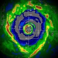
Ernesto's structure has improved, and most remote sensing data supports the upgrade back to hurricane status. It does have some characteristics of a reformed core eye band, if intermediately broken. However, I don't think the recent convective bursting is strong enough for any substantial strengthening back to Category 2. Reintensification in line with some increase in ADT values is currently around 75 kts / 85 mph. If it were to continue bursting and wrapping up, sure, perhaps Category 2 is possible again tonight, though the window for this is closing.
-
2024 Atlantic Hurricane Season
Windspeed replied to Stormchaserchuck1's topic in Tropical Headquarters
The 2024 season has been incredibly efficient. The first five named storms have made landfall. I'm not sure I can ever recall that occurring in previous seasons since tracking as a kid. -
000 WTNT45 KNHC 170857 TCDAT5 Hurricane Ernesto Discussion Number 23 NWS National Hurricane Center Miami FL AL052024 500 AM AST Sat Aug 17 2024 Satellite and surface observations indicate that the center of Ernesto made landfall on the western side of Bermuda at about 430 AM AST, with the National Museum of Bermuda recently reporting light winds and a central pressure of 972 mb. The system overall has become less organized as drier air has infiltrated much of the circulation's southern semicircle. Earlier aircraft reconnaissance data supported 75-80 kt as an initial intensity, and with the degradation in the satellite imagery, 75 kt is chosen as the current intensity (and operational landfall intensity). The Air Force Hurricane Hunters should be out again in a few hours to sample the cyclone. While the current moderate shear is forecast to weaken today, it will take some time for the vortex to recover from the dry air as it moves across warm waters north of Bermuda. Thus little change inintensity is anticipated in the short term, and re-strengthening could begin tomorrow. This should be a fairly short-lived window, however, since Ernesto will be crossing the north wall of the Gulf Stream on Monday while moving into a strong wind shear environment. Therefore, steady weakening is forecast for the work week, and Ernesto is expected to complete extratropical transition near or just east of Newfoundland. The NHC intensity forecast is largely an update of the previous one, a bit lower in the short-term to account for recent guidance. Ernesto has turned more to the north-northeast overnight and slowed down to about 8 kt. The motion should creep in that direction today as the hurricane is stuck in an area of lighter steering currents, waiting for the next trough to move off the U.S. East coast. This slow motion and Ernesto's large size will cause a long duration of impacts through tonight on Bermuda. The trough should force the cyclone to accelerate northeastward later in the weekend and early next week, taking Ernesto near Newfoundland Monday night. The guidance is again slower than the previous cycle, so the NHC track forecast is trended in that direction. Global model fields depict that Ernesto should open into a trough, or become absorbed in a larger polar low by 120 h over the northern Atlantic ocean, thus the NHC forecast now shows the system dissipated at that time. Key Messages: 1. Ernesto is expected to bring periods of strong winds, storm surge and battering waves on Bermuda through tonight. A hurricane warning is in effect for the island, and residents there should listen to orders from local officials. 2. Heavy rainfall from Ernesto will continue to impact Bermuda through tonight and will likely result in considerable life-threatening flash flooding, especially in low-lying areas on the island. 3. Even though Ernesto is forecast to remain well offshore the U.S. East Coast, swells generated by the hurricane are expected to affect the area through the weekend. Beach goers should be aware of a significant risk of life-threatening surf and rip currents, and stay out of the water if advised by lifeguards. Surf and rip currents are also possible on the Bahamas, Bermuda, and Atlantic Canada during the next few days. 4. Interests in Atlantic Canada should monitor the progress of Ernesto. FORECAST POSITIONS AND MAX WINDS INIT 17/0900Z 32.3N 64.8W 75 KT 85 MPH 12H 17/1800Z 33.3N 64.4W 70 KT 80 MPH 24H 18/0600Z 34.6N 63.9W 70 KT 80 MPH 36H 18/1800Z 36.6N 62.9W 75 KT 85 MPH 48H 19/0600Z 39.8N 61.2W 80 KT 90 MPH 60H 19/1800Z 43.5N 57.5W 70 KT 80 MPH 72H 20/0600Z 47.0N 51.5W 60 KT 70 MPH...POST-TROPICAL 96H 21/0600Z 51.5N 32.0W 40 KT 45 MPH...POST-TROP/EXTRATROP 120H 22/0600Z...DISSIPATED $$ Forecaster Blake
-

2024 Atlantic Hurricane Season
Windspeed replied to Stormchaserchuck1's topic in Tropical Headquarters
That's one hell of a hypothesis by Webb. Alarming, even: -
As has been discussed thoroughly in the thread, Bermuda is built to handle strong hurricanes. But you are silly to downplay this as a non-story. 17k+ are now without power, and there will still be further grid and infrastructure damage. They will most likely have any old-growth tree damage that may've survived previous storms. Additionally, there will be some roof damage regardless of the quality of building/wall supports with 80-90+ gusts occurring. We'll need to be patient and see the aftermath and damage assessment in the coming days. It does look like the low-level vortex is going to make landfall.
-

2024 Atlantic Hurricane Season
Windspeed replied to Stormchaserchuck1's topic in Tropical Headquarters
This year has been more quality versus quantity so far. We're on the 'E' storm. Some of the more recent high number of named storm seasons also saw a lot of weaker TCs and ST systems that formed in the early months. This year we've only had two weak systems develop that did not become hurricanes. Even Chris probably would have become a BOC 'cane given more time over water. I suppose we may still see a plethora of central Atlantic systems form at higher latitudes during September and October besides the more potent southerly systems. But overall, I don't think this year would be remembered by busting on total number of named storms if indeed we do witness a significant number of intense hurricanes. Again, quality over quantity. 2017 was a horrible record season that did not hit 20 named storms. Only 17 formed that year, in fact. -

2024 Atlantic Hurricane Season
Windspeed replied to Stormchaserchuck1's topic in Tropical Headquarters
To continue the above discussion, here's an excellent thread by Kaylan Patel on upcoming developments with regards to the WAM, the MDR, and pattern placement by September. -

2024 Atlantic Hurricane Season
Windspeed replied to Stormchaserchuck1's topic in Tropical Headquarters
Agreed. Need I remind everyone that it is August 15th. Conditons are not yet prime. The proverbial switch generally flips by the last week of August (as per the climatological norm) for a more favorable MDR, regardless of whether the season is to finish as hyperactive or not. Yet, even though we've had easterly SAL plumes and periods of shear, we've had three hurricanes, two of those as landfalls (potentially three), with two reaching Cat 2. Beryl's early season rampage through the Caribbean may be an anomaly, but I'm fairly confident we'll be dealing with several big ACE producing CV long-trackers that will likely drive through the islands again unfortunately. One or two may become GOM threats. The ECONUS trough most likely will give way to re-extension of the SPH by September. To add, with near-record SSTs in place across the basin and the evolving La Niña, we may see a burst of late season activity as well. Certainly, October may be similar to September in pattern and continued late season MDR development we have seen in previous years. Obviously, the more typical WCARIB / CAG developments by November. -
Pretty large dry slot circulating around Ernesto's core. That feature has stubborn persistence and will most likely delay any period of significant intensification until the stable airmass mixes out. The pressure has dropped some since last night due to persistent convective bursting in Ernesto's core, but the gradient isn't tightening up as long as that dry alot remains and the outer bands are slow to contract. At any rate, this is good news for Bermuda. The upper-level environment is very condusive for a strong hurricane as discussed previously. A steady state to slow strengthening into tonight. If the dry slot does eventually mix out and contraction begins, then perhaps more significant intensification tomorrow per official forecast.
-
As a sidenote to the 00z GFS run I used for that image above, it again not only flirted with a direct hit on Bermuda as in previous runs but actually makes landfall. Again, just one operational run with plenty of lead time to go. It would be pretty impressive for such a small geographic location to get accurately modeled for a direct impact even 48-60 hours lead time. Major grains of salt here!! This most likely will not occur, but it is interesting to note nonetheless.
-
I had failed to notice this earlier, but look at this outflow setup by tomorrow evening. Obviously, westerly mid-level shear from the approaching mid-level trough (Midwest region) has not yet impacted Ernesto, but the upper trough is positioned perfectly to evacuate airmass to the NNE. Additionally, there is a developing TUTT to evacuate airmass to the south. So we have dual poleward outflow jets being modeled here. If Ernesto times this right, given the abnormally warm SSTs it will be traversing over, potential exists for a decent rapid intensification phase at some point today.
-
That doesn't mean that Ernesto will peak like Franklin. It's not the same setup. The point I think is trying to be made here is that the models are a mere tool and a weigh of potential. They are often times errors. No need in hugging one suite of runs like it is definitely going to occur IRL. No need to take offense. It's all a learning process. You're not being picked on, sir. As such, why I posted them above is to show potential. But I also made aware that they are very likely being overdone. At least that is my hope. 950s seems very realistic. 930s, not so much.
-
Yes, the big caveat here is that just like operationals often times underperforming with TC intensity, as is their inherent design (not a flaw), TC models often times overperform. There are always caveats and to err on the side of caution. Nothing beats in situ data. We'll need recon to verify if Ernesto is definitely going to start any rapid deepening tonight or obviously a substantial increase in ADT. We don't even have a clear eye yet, though that is probably coming.
-
I wouldn't focus too much on the overall run-time intensity for the operationals. Granted, sure, if they're also showing rapid deepening, then it bears notice. But generally speaking, OPs do not handle TC intensity fluctuations as well as the TC models, especially the HAFS suites. I think it's important to mention that virtually all of the TC models do bring Ernesto to major hurricane status. The most recent runs: HWRF - 955mb HMON - 950mb HAFS-A - 944mb HAFS-B - 935mb Obviously, I'm hoping that the HAFS suites are overdoing Ernesto a bit here. However, given that shear is relaxing over the next few days and the core will be turning into a more diffluent environment with trough interaction, at least prior to an increase in mid-level SW shear, the window is there for rapid intensification. Can't rule out Ernesto overperforming while atmospheric conditions are condusive. SSTs are definitely supportive unless Ernesto slows down or stalls (upwelling).
-
An intense convective burst is underway over Ernesto's center, which also looks aligned with the mid-level vortex. That's an impressive burst. I would expect the pressure to begin falling now. The bottle may have just been uncorked per se.
-
Puerto Rico is still experiencing heavy rain from enhanced southerly flow out of the ECARIB due to Hurricane Ernesto's backside feeder bands. Precipitation is not as widespread in coverage as last night and this morning, but training cells continue to develop. Hopefully, heavy downpours subside overnight as Ernesto continues to pull away.
-
Adamantly in disagreement with this "analysis". They are treating this system as if it were already a former powerful hurricane ( > 960s hPa) that had weakened into a broad tropical storm / hurricane with a sloppy and wide surface sub-pressure regime ~980s hPa. In Ernesto's case, it was an organizing broad trough/circulation with a background mean ~1008 hPa, which is in no way comparible. For example, if Ernesto's core begins to take off overnight and undergoes a significant drop in pressure, its broad circulation envelope and low pressure trough matters not. The gradient between the former surface trough and anything below 960 hPa in Ernesto's core is going to create a tight gradient, and winds will respond accordingly. Ernesto will absolutely become a major hurricane if its core pressure reaches that threshold.
-
Ernesto is beginning to develop some deeper convection. However, at present, a strong mid-level circulation with CBs is displaced WSW of the low-level circulation. That being said, the system overall does appear to be improving with time. The TC is still moving at a rapid pace. It likely won't begin to undergo more significant intensification until its forward motion slows and the core can better align.
-
No worries. I totally agree. There are a few islands on this planet that are battle hardened and seaworthy for high-end wind events. Bermuda is among the best prepared. I'd add Taiwan to that short list as well. Edit: Actually, a great example of this is the Grenadines. Located in the Windwards, they are quite used to high wind events and build accordingly, regardless of annual hurricane threats. As such, their structures held up quite well during the impact of Beryl's eyewall. The topography mitigated surge impact except for immediate harbor shorelines due to wave action. But unfortunately, many structures still did get deroofed. Vegetation and grid were also stripped and broken down. Simply put, despite their mostly concrete and well-built infrastructure, Carriacou, Petit St. Vincent and Union Island were all devestated.
-
It's interesting that you make that bold statement. A recent article published in the Bermudian presents the what ifs and hypotheticals about high-end hurricanes and Bermuda, answered by Andy Moore, whom I believe used to frequent this board quite often as @OSUmetstud , though it's been a while since I have seen him post. Now, please do not think that just because I am posting this article, I am in any way suggesting that the eventual hurricane that this thread seeks to analyze will hit Bermuda. That being said, Bermuda has had some close calls with direct hits over the past thirty years by high-end TCs. I do not think it bold to predict that a Category 5 will eventually strike that island in the next few centuries. We are seeing increased OHC in the shallower immediate surface layer creeping upwards of 29-30°C. A real possible scenario is a rapidly intensifying and fast-moving major hurricane imbedded within a favorable upper trough. It is the inevitable worst-case scenario that will unfold that Bermuda takes a direct impact from a Category 5, even if not in our lifetimes. https://www.thebermudian.com/home-a-garden/hurricane-season-2024/__trashed-7/
-

2024 Atlantic Hurricane Season
Windspeed replied to Stormchaserchuck1's topic in Tropical Headquarters
Though the official forecast calls for PTC5 to eventually reach Category 2 status in the WATL, I do feel confident now that this system will reach major hurricane intensity north of the Antilles on its trek north. That would give us three hurricanes prior to August 26th (climo. norm is two), including two majors by September 1st (climo. norm for one). I would be surprised if there isn't a third major prior to September 1st. Additionally, we should remain on pace to reach hyperactive numbers by season's end following PTC5/Ernesto's completion, which should put us over 50 by August 20th (climo. norm is September 6th). -
If sustained convection can tighten the broad circulation, 98L shouldn't be long for classification. Note the strong, westerly motion within the low-level cloud flow on visible in the southern half of the disturbance. Low pressure is defined, and the wave axis has folded. If the system can tighten up a bit, it may outperform prior to the Antilles. There is a notable diffluent pattern aloft for a TC in this setup on the approach to the Leewards that would support an intensifying hurricane. Hopefully, it takes time for the broad circulation to tighten. Good post on the aforementioned setup here:
-

2024 Atlantic Hurricane Season
Windspeed replied to Stormchaserchuck1's topic in Tropical Headquarters
If you're looking for pattern scenarios to favor higher ECONUS threats of a major hurricane landfall, the upcoming short-term cutoff trough is one of the patterns you would entertain in the coming week. Of course, such a pattern may still lead to a recurve of a hypothetical TC and no land interaction for the continental US. However, as opposed to a strong mid-level trough with jetstream, a cutoff opens the door for mischief in the steering layer. If a TC is positioned north of the GA and has gained enough longitude, reaching nearto the Bahamas, rebound of the SPH and a Canadian block NE of an ECONUS cuttoff could allow hypothetical TC to turn back NW into the Eastern Seaboard, or recurve from a position where the Carolinas and New England are under threat. We aren't looking at sure fire OTS jetstream-induced recurve here. Even if the hypothetical TC turns N, it may get caught under rebounding heights. Just be very skeptical with this setup on the ECENS of early suggestive OTS tracks until 1) we actually know how low in latitude the TC is going to track with respect to the ECARIB, and 2) timing of ECONUS cutoff trough. There will be a wide degree of any possible positions and tracking scenarios seven days out that may change drastically without a true longwave trough. Increased uncertainty around the fact there will be strong 500 hPa heights postion north of the cutoff that may expand east just in time for the hypothetical TC to have lifted near or just east of the Bahamas. The midrange models may not begin to handle that feature better until we are a few more days advanced. We have seen this occur in previous years. Dorian comes to mind. Nearly all modeling swung back drastically from an OTS to a sharp bend back west when the ensembles had a better grip on the ECAN dome. First and foremost, this system has a high chance of land interaction. So regardless of any potential ECONUS threat or non-threat, if a TC develops, it's likely to be at a low enough latitude to impact the Lesser Antilles and eventually one of the GA.

