

TWCCraig
-
Posts
2,604 -
Joined
-
Last visited
Content Type
Profiles
Blogs
Forums
American Weather
Media Demo
Store
Gallery
Everything posted by TWCCraig
-
Huge contrast in temps today on the island. Low 40s on the barrier islands and socked in fog. Sunny at home but only 57.7 and low to mid 60s on the north shore Much cooler than yesterday out here due to the fog
-
63 already, overpreforming so far. Yesterday underperformed here with a high of only 58.8, then a high of 59.3 around 11:30pm when the front finally pushed the sea breeze offshore Not sure where we'll end today, probably won't hit 70 on the south shore, but 63 with a sea breeze is pretty good so far
-
Some graupel/sleet falling from a passing shower. Was curious to see whether it would rain or snow, but got neither lol
-
50 here with beautiful sunshine, sea breeze capping temps a bit. High of 52.2 is the warmest since December 19th
-
Very hard to measure with the drifts but we have some drifts over 4 feet in some spots!
-
Got you
-
-
Insane heavy snow! Dont think I've ever seen conditions like this!
-
Definitely. I can't tell if the -7°F was more due to radiational cooling or strong CAA. A weather station in Setauket on LI recorded -1°F on 2/8/1934, and -11°F the following night on 2/9. NYC hit -15°F that night (2/9) meaning it was a few degrees warmer on LI during that cold snap, at least in Setauket. Though the Setauket station was closer to the water. That suggests some serious CAA that favored NYC with more cold than LI. I don't have wind data, but I'd assume there was a northerly wind, with a wind over the LI Sound keeping the Setauket station a bit warmer. Depending on wind speed & direction, NYC can get colder than LI. In 2016 NYC hit -1°F, ISP bottomed out around 0°F
-
3.6°F this morning, coldest of the season here was on the 31st of Jan at 3.5°F NYC hit 3°F as well, though the daily record low is -7°F set in 1934. I can only wonder what temps were like around the region at that time
-
13.8°F breezy with light snow
-
+3.5°F for the low here. Looks like -2°F at Shirely and -9°F at Westhampton for lows. -8°F in Toms River -9°F in Somerville -11°F in Morristown Unofficial numbers though
-
8.9°F this morning. Coldest of the year so far but tonight should be colder if winds go calm. Interested to see what spots can radiate good tonight, wouldn't be surprised to see double digit negatives in the pine barrens of LI and NJ and other isolated low lying areas
-
A little sleet mixing in now. 8" otg
-
15.7°F with heavy snow Probably the coldest snowstorm here (so far) since 2014. I think that winter BOS had heavy snow at 2°F during a storm
-
Light snow, already have a coating
-
 Yes, but early this morning before the clouds settled in out here you were able to look at the sun without any sunglasses. Pretty neat
 -
Compared to other mornings, temperatures are a little slow to climb with all the smoke. Low of 63, only 67 right now. You were able to stare at the sun this morning, no sun glasses needed
-
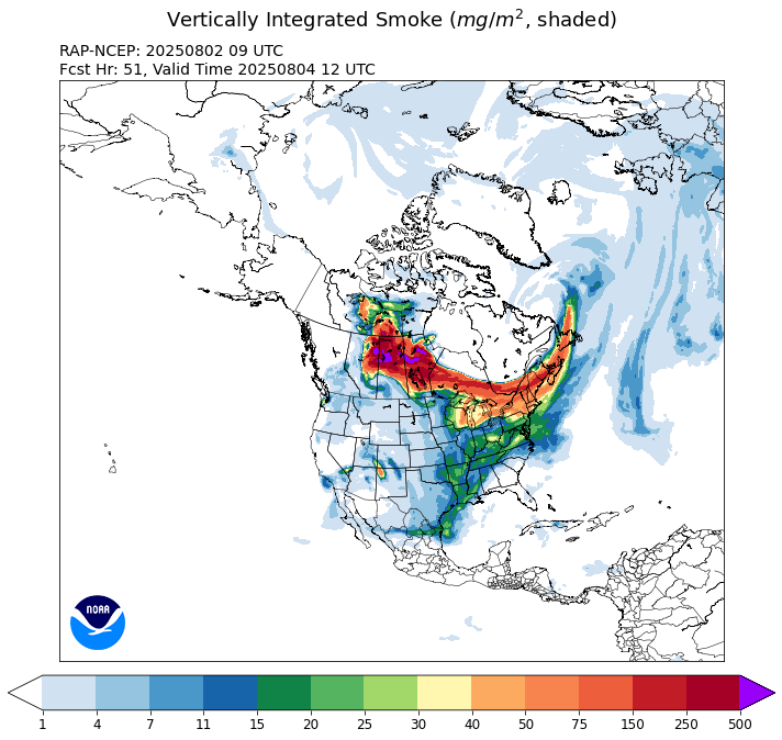
Long range RAP holds off most of the smoke until Monday. Worst of it will be north of here. HRRR has the same progression, but isn't as thick
-
July 2025 Discussion-OBS - seasonable summer variability
TWCCraig replied to wdrag's topic in New York City Metro
91/68 HI 95 Hot, but dews aren't atrocious today -
July 2025 Discussion-OBS - seasonable summer variability
TWCCraig replied to wdrag's topic in New York City Metro
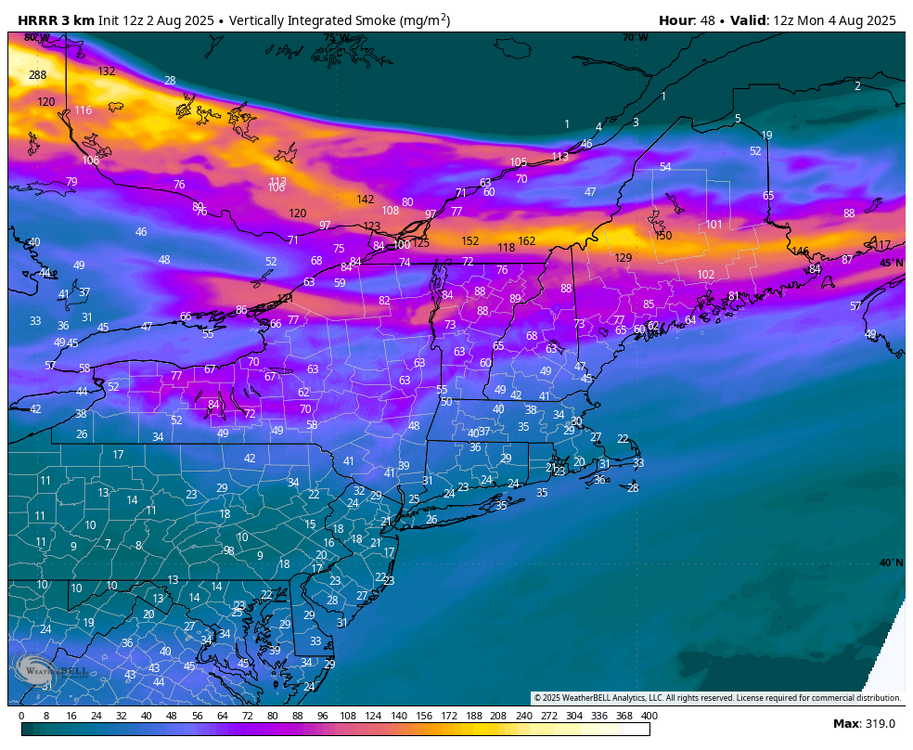
Visibility down to 5 miles in Boston with smoke mixing down to the surface. Some of that will mix into the area later. This smoke isn't elevated HRRR near surface smoke for 4pm:
-
July 2025 Discussion-OBS - seasonable summer variability
TWCCraig replied to wdrag's topic in New York City Metro
Like I said my dew point dropped, I had a higher dew point this time yesterday but tonight there's a westerly wind here so my temp shot up -
July 2025 Discussion-OBS - seasonable summer variability
TWCCraig replied to wdrag's topic in New York City Metro
Still 87, but my dew point is down to 75 from the upper 70s earlier. Long Island doesn't cool down on a westerly wind, thats why temps havent dropped, and gone up in some spots like here -
July 2025 Discussion-OBS - seasonable summer variability
TWCCraig replied to wdrag's topic in New York City Metro
Temps starting to climb back up now that the "dry" front has passed. I was down to 84, now up to 87 with a dropping dew point -
July 2025 Discussion-OBS - seasonable summer variability
TWCCraig replied to wdrag's topic in New York City Metro
88/78 Dew point of 79 at Westhampton KFOK


