TWCCraig
-
Posts
2,652 -
Joined
-
Last visited
Content Type
Profiles
Blogs
Forums
American Weather
Media Demo
Store
Gallery
Everything posted by TWCCraig
-
57.9 this morning 3 consecutive nights below 60 degrees in July, last time that happened out here at ISP was 2018
-
Some unofficial lows around the area this morning: Monticello: 48 Somerville: 52 Toms River: 51 Westhampton: 50 East Hampton: 50 Central Park: 66
-
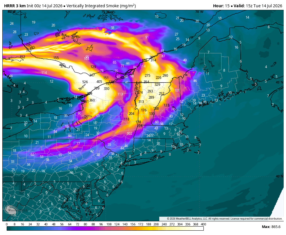
Still a little bit of low level smoke, but skies are much clearer overall. It's great seeing the sun again! HRRR brings some smoke back in later tonight with the sea breeze. Looks pretty clear by Sunday
-
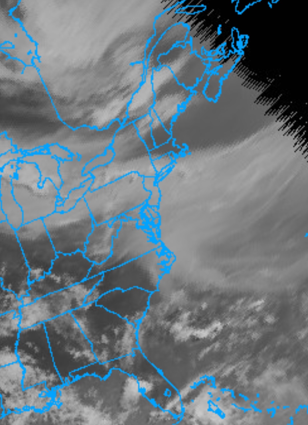
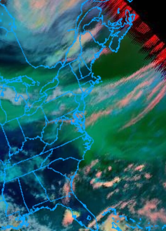
Since GOES-EAST is down, you could use GOES-WEST, though it's not ideal since we're near the edge of the disc image, so images appear blurry but its better than nothing. The colored image distinguishes between cloud types. Smoke is green, blue and red are clouds

-
GOES-19/GOES-EAST is down so currently there's no live satellite imagery for the entire eastern half of the country.
-
Could have been near 100 or greater for most of the island if it wasn't for all the smoke. Low 80's on the north fork. High of 94 down to 92 with the smoke getting thicker. Shadows are gone, not too much smoke near the ground but it's definitely visible.
-
Smoke from wildfires in Ontario and Minnesota near the border will make its way into the area tomorrow. This smoke is mostly elevated so it'll make tomorrow's skies more gray than blue. Wednesday's heat potential is significant for coastal locations. Decent WNW wind could allow temps near 100 right to the beaches

-
Out in Shoreham right now, got absolutely smoked with strong winds and torrential rain
-
It's a joke, hence the "lol". It shouldn't be an issue
-
99.7! Rounds to 100 lol Getting compressional heating from the sea breeze front Edit: Maxed at 99.8 at 2:08, down to 96.8/76.8 as of 2:25
-
I fell just short last year with 98 degrees. Yea the last time we had widespread 100s here was 2011. My PWS at the time wasn't properly sited but reached a high of 104, probably 100-101 if it was in a good spot I think we also hit 100+ in 2010, we had so many days that summer with a hot NW wind Up to 98 right now with the sea breeze still holding off for now
-
97/72 w/ NW wind here on the south shore of LI Making up for all those days with a sea breeze. Probably will fall just short of 100 here before the sea breeze comes through
-
Up to 95/72, hottest temp of the heat wave so far. South shore is roasting right now with a NW wind
-
Meanwhile here on the south shore lol
-
Down to 91/78 but feels like 106 Maxed at 94 here, ISP hit 97 with compressional heating from the sea breeze front. It's now down to 92/78 Traded off higher temps for higher dews near 80
-
Very light sea breeze so far. We'll have to wait until the afternoon for any relief Holding around 93/79
-
91/77 Not much of a sea breeze right now, expecting it later by noon. Already far warmer than yesterday's high of only 84
-
82/73 Max of only 84.4
-
0.13" from this morning and only 1.02" for the entire month of June. The entire south shore is dry as a bone! Currently only 81/72
-
86 yesterday on the south shore For Long Island, the Euro has a prominent sea breeze on Thursday so Euro only has 90s for the island that day. West wind comes back on Friday (Euro) so that would be our best chance at 100+. GFS has more of a westerly wind both days but there will probably be a sea breeze both days. Where it sets up during the day will dictate the max temps. Longer it holds off, the hotter it'll get
-
Only got 0.27" Monday-Tuesday and only 0.88" so far for the entire month of June. Pretty typical of the south shore this time of year. 0.66" at ISP is the second driest June on record but we still have a few days to go with some rain chances. Only 1988 and 2005 were drier through the first 24 days of June. ISP has not seen a June with above normal precipitation (at least 3.77") since 2013 when we had 8.03". Since 2019, ISP has not seen a June with more than 2.27" of rain. '20, '21, '23, '24, and '25 all finished with rain totals less than 2". 2026 will likely be added to that list.
-
93/72 with a NW wind, sea breeze just south of here 0.20" last night
-
86/74 Maxed out at 92
-
41.6°F this morning here. One of the coldest for this late in the season Westhampton dropped to 30°F this morning. This is the latest freeze on record for KFOK. Old record was May 22nd with 32°F set in 2002. More recently, in 2020 the low was 33°F on June 1st
-
This is at one of the rail stations, around 3,800 ft elevation. Beautiful morning there. Most cams on the mountain are snow covered