

mitchnick
-
Posts
28,725 -
Joined
Content Type
Profiles
Blogs
Forums
American Weather
Media Demo
Store
Gallery
Everything posted by mitchnick
-
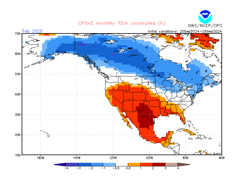
Cansips pretty much held serve from last month's forecast, and looks a lot like the Cfs2 too tempwise.
-
Cfs2 says grab the catchup and mustard.
-
Updated Cansips is out later today or this evening. Let's see if it gives any support to the Cfs2, which continues to keep MW & East north of Virginia with average temps and precip for Dec-Feb.
-
I agree of it's prominence thanks to the -PDO, but the degree of the ridge breaks down in a couple of days and much can change during the winter months some 3-6 months later imho.
-
Don't think we should take too much away for winter from progged weather on 10/3.
-
Central PA Autumn 2024
mitchnick replied to Itstrainingtime's topic in Upstate New York/Pennsylvania
Mushrooms are getting real big around here, like 6" round. -
Central PA Autumn 2024
mitchnick replied to Itstrainingtime's topic in Upstate New York/Pennsylvania
With the Euro losing it's edge thanks to unsuccessful "upgrades", we're probably best using the NWS blend of models. No guarantees, of course. https://www.pivotalweather.com/model.php?m=nbm&p=prateptype_cat_ecmwf-imp&rh=2024093006&fh=6&r=conus&dpdt=&mc=&pwplus=1 -
I think you're looking at last year's map.
-
Central PA Autumn 2024
mitchnick replied to Itstrainingtime's topic in Upstate New York/Pennsylvania
Just .1 -
Central PA Autumn 2024
mitchnick replied to Itstrainingtime's topic in Upstate New York/Pennsylvania
As a guitar player of 51 years, 80's hair bands had some (but not all) great shred guitarists and 90's grunge had no great guitarists, at least that I ever heard. -
Central PA Autumn 2024
mitchnick replied to Itstrainingtime's topic in Upstate New York/Pennsylvania
I saw that. Lousy minds can think alike too! -
Central PA Autumn 2024
mitchnick replied to Itstrainingtime's topic in Upstate New York/Pennsylvania
It sorta looks like the Midwest front is coming in a little earlier than previously progged, so things don't have a chance to develop and get pushed off the east coast. -
Central PA Autumn 2024
mitchnick replied to Itstrainingtime's topic in Upstate New York/Pennsylvania
Good news is that the globals have lost the strong GOM system. Hopefully, that trend continues. -
You got married in March, if I'm not mistaken. You should be in bed with your bride at 3 or 4 in the morning instead of posting here! Lol
-
I think he was focusing on the strength of it.
-
-
Central PA Autumn 2024
mitchnick replied to Itstrainingtime's topic in Upstate New York/Pennsylvania
Mushrooms getting plentiful and huge. -
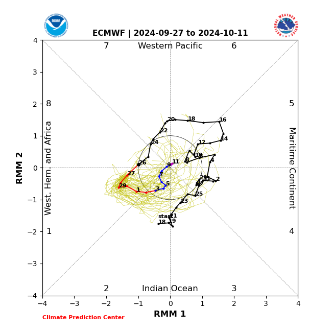
Helene developed in the Gulf of Mexico per attached and with rapid development occuring in the last 24 hours west of Florida. Color me skeptical on the Atlantic warming as much, if any, of a major factor, especially in light of the MJO. But that's just mho.
-
Don't discount the MJO as a factor.
-
Central PA Autumn 2024
mitchnick replied to Itstrainingtime's topic in Upstate New York/Pennsylvania
My sister came soooo close to moving to Florida, but didn't. I like visiting beaches but would/have never considered living at one. -
Months of a weak Niña Enso is for certain. Whether we get the requisite 5 trimonthlies to qualify as an official weak Niña remains a question in my mind. Mainly because waters seem to go to neutral pretty fast after December from what I've seen. But maybe I'm not looking at the right stuff, idk.
-
Central PA Autumn 2024
mitchnick replied to Itstrainingtime's topic in Upstate New York/Pennsylvania
That's bad. I really hate severe weather i.e. t-storms, lightning, hurricanes. Did your friend have flood insurance? With no history of flooding, it may not have been required or offered. -
Could be, but we'll just have to see if 1) it develops as progged and, 2) the actual response. As we've this year, trying to predict ocean water temps around the world has been tough, seemingly tougher than usual. P.s. I would hope that October updates starting next week can reach a consensus on the Niña with some degree of accuracy.
-
Central PA Autumn 2024
mitchnick replied to Itstrainingtime's topic in Upstate New York/Pennsylvania
I assumed that 20 minute wait at McDonald's was a life altering experience. -
That map jibes with the link below that shows some cooling around Japan and a migration east, while also weakening, of the warmest N Pacific anomalies. https://psl.noaa.gov/map/clim/sst.anom.anim.week.html


