jojo762
-
Posts
4,228 -
Joined
-
Last visited
Content Type
Profiles
Blogs
Forums
American Weather
Media Demo
Store
Gallery
Everything posted by jojo762
-
Still plenty of 100-120mph bins showing up on KMBX at ~3KFT. Impressive given that Zeta has been on land for nearly 300 miles now.
-
Given all these highly impressive sustained winds/gusts, this will almost certainly be upgraded in post-storm analysis. 136mph?? That’s pretty top-tier, as anything higher (and usually a lot of gusts lower than that) destroys anemometers.
-
GFS = most bullish with snow/ice Euro = most bearish with snow/ice CMC = in the middle with snow/ice Ive seen this a few times... guess who wins?
-
Obviously the satellite presentation has become fairly impressive, but a bit surprised that NHC continues to nudge up the intensity. Hasn’t been much flight-level and certainly not any SFMR data to support 120mph. edit: does look like the NOAA plane did just find 111kt (128mph) FL-winds though..
-
Highest FL wind was 87kt though... so that SFMR of 91kt is a bit suspect.
-
Recon didn’t go straight through the eye like normal, they turned a bit once inside, hence the abnormal readings.
-
Potential eye of Delta has warmed to ~-40C on IR compared to the ring of <-80C towers around it.
-
Tomorrow is probably gonna be a fun day, anticipate rapid re-intensification... Outflow and cloud/convective patterns have greatly improved with Delta today... Latest IR imagery is pretty telling that it’s about to take off as we have intense convection starting to wrap around the COC.
-
Looks like recon extrap pressure was just a tad below 977mb. Not bad. Swath of hurricane and tropical storm force winds is much broader now, albeit there isn’t really an obvious wind max now near the eye.
-
Dropsonde data suggests that the pressure jumped 10mb from 963 to 973 from the second to the third pass... seems off?
-
Tiny eyes = higher potential for rapid changes upward/downward... still a hocked that this went from a rapidly intensifying 145mph category 4 to a 85-100mph storm (the upper end of that is probably generous).
-
Current IR presentation is definitely bottom-tier for a 140mph category 4 hurricane... imagine it’ll improve overnight prior to nailing Cancun.
-
I assume NHC is going to be coming out with a special advisory to update the intensity forecast? That’s 15mph off from what was initialized at 10pm CDT.
-
Per latest NHC update, Delta is now a hurricane.
-
NHC now forecasting a major hurricane to impact Yucatán peninsula, including Cancun. Yikes. Anyone happen to know what the oceanic shelf is like there (how surge prone it is)?
-
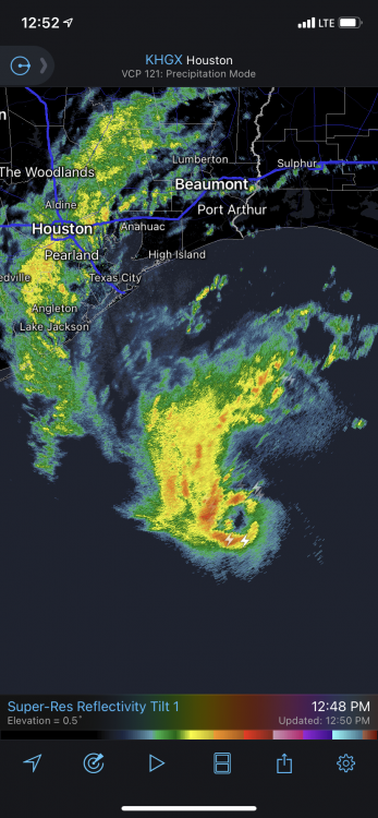
Certainly an interesting look to the core of Beta this afternoon on KHGX...
-
Today features an extraordinarily anomalous setup (at least I can’t exactly recall seeing anything like it) across large parts of Washington and Oregon, where an ENH risk for severe wind gusts exists.
-
Good luck! Potential for “better” more interesting chases later on in the week possibly. Don’t get too burnt out on driving by then Quincy!
-

Central/Western Medium-Long Range Discussion
jojo762 replied to andyhb's topic in Central/Western States
Looking like those long range ensembles from May 8th are going to verify. Looking at a multi-day period starting mid-week with severe potential along a lengthy portion of the high plains... followed by what will likely be several days of severe storm opportunities from Thursday-Sunday in the central and southern plains. Models diverge a bit on details and days of interest, so it’s hard to nail down many specifics. Good chance we don’t see any days delineated in tonight’s D4-8. For example, though, the GFS is more aggressive with Thursday and Saturday, while the Euro is aggressive with Thursday (in an area much further west than the GFS) and on Sunday. -
Was on the same storm as Quincy. Took me a while to leave my original target to go after it... but still made it just in time to at least get some structure w/ a wall cloud. As he stated, wasn’t very much rotation, but altogether not awful given my minimal expectations for the day.
-
Today features a chance for isolated tornadoes across SW IA. A surface low will be positioned near the IA/NE border by 00z, this low will gradually pull moisture poleward throughout the afternoon. Impressive low-level cape 100-150J/kg will exist to the southeast of the low this along with easterly SFC flow aiding in decent low-level hodograph curvature, marginal MLCAPE, and low LCLs could create a sneaky day for a couple of tornadoes across this area. Seeing as to how I’m only about two hours away, I think I’ll give it a swing. Not expecting much, but it’s a fairly short drive. Somewhat ironically last night I was thinking Clarinda, IA was a good target, and Jeff Frame on twitter actually posted this as his hypothetical chase target of the day.
-
Central/Western Medium-Long Range Discussion
jojo762 replied to andyhb's topic in Central/Western States
00z GFS jumped on the bandwagon for next week as well... depicts two severe days across the plains on Wednesday and Thursday. With Wednesday possibly featuring higher-end tornado potential... stay tuned! -
Central/Western Medium-Long Range Discussion
jojo762 replied to andyhb's topic in Central/Western States
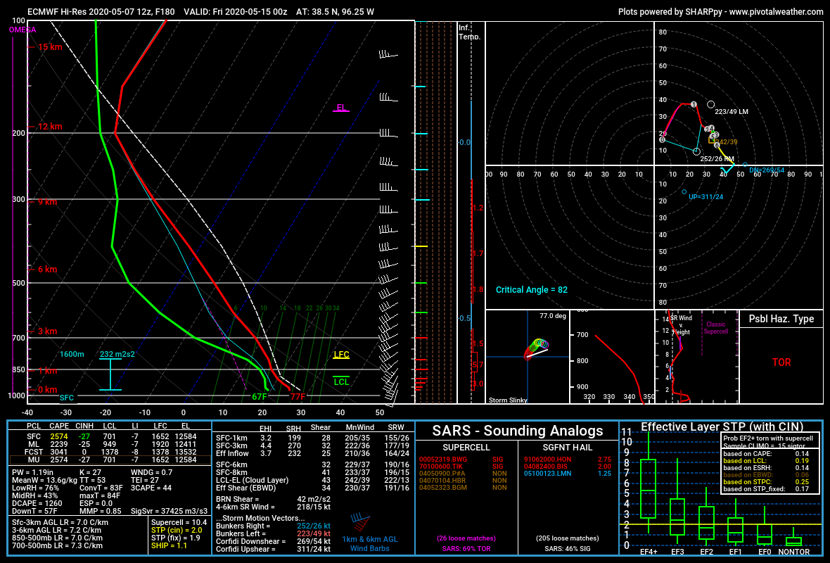
Not a whole lot of model agreement or high predictability, but mid/late next week was pretty interesting on the 12z Euro, especially Thursday. Obviously slightly veered SFC winds aren’t exactly preferred in the plains, but it’s a start. P.S. Highly recommend getting Pivotal Weather Premium, at least for severe season; it’s not that expensive, and being able to get high quality ECMWF soundings is fantastic.
-
Central/Western Medium-Long Range Discussion
jojo762 replied to andyhb's topic in Central/Western States
And if this were the case... I would say that that time frame would end up being equal chances for both... maybe slightly below normal chances? Not sure yet, because it’s so far out that it is almost pointless to try to predict severe weather given the various intricacies of a severe weather forecast. Bleak forecast for storms, or even just tranquil weather the next week. -
Central/Western Medium-Long Range Discussion
jojo762 replied to andyhb's topic in Central/Western States
Monday is looking like a classic boom or bust triple point day... should be noted that there is a pretty wide disparity between the ECMWF/UKMET/CMC and the GFS/NAM though... GFS and NAM show what would be a pretty upper-crust supercell environment (with some caveats/possible weak points).