frostfern
-
Posts
1,984 -
Joined
-
Last visited
Content Type
Profiles
Blogs
Forums
American Weather
Media Demo
Store
Gallery
Everything posted by frostfern
-

2022 Short/Medium Range Severe Weather Discussion
frostfern replied to Chicago Storm's topic in Lakes/Ohio Valley
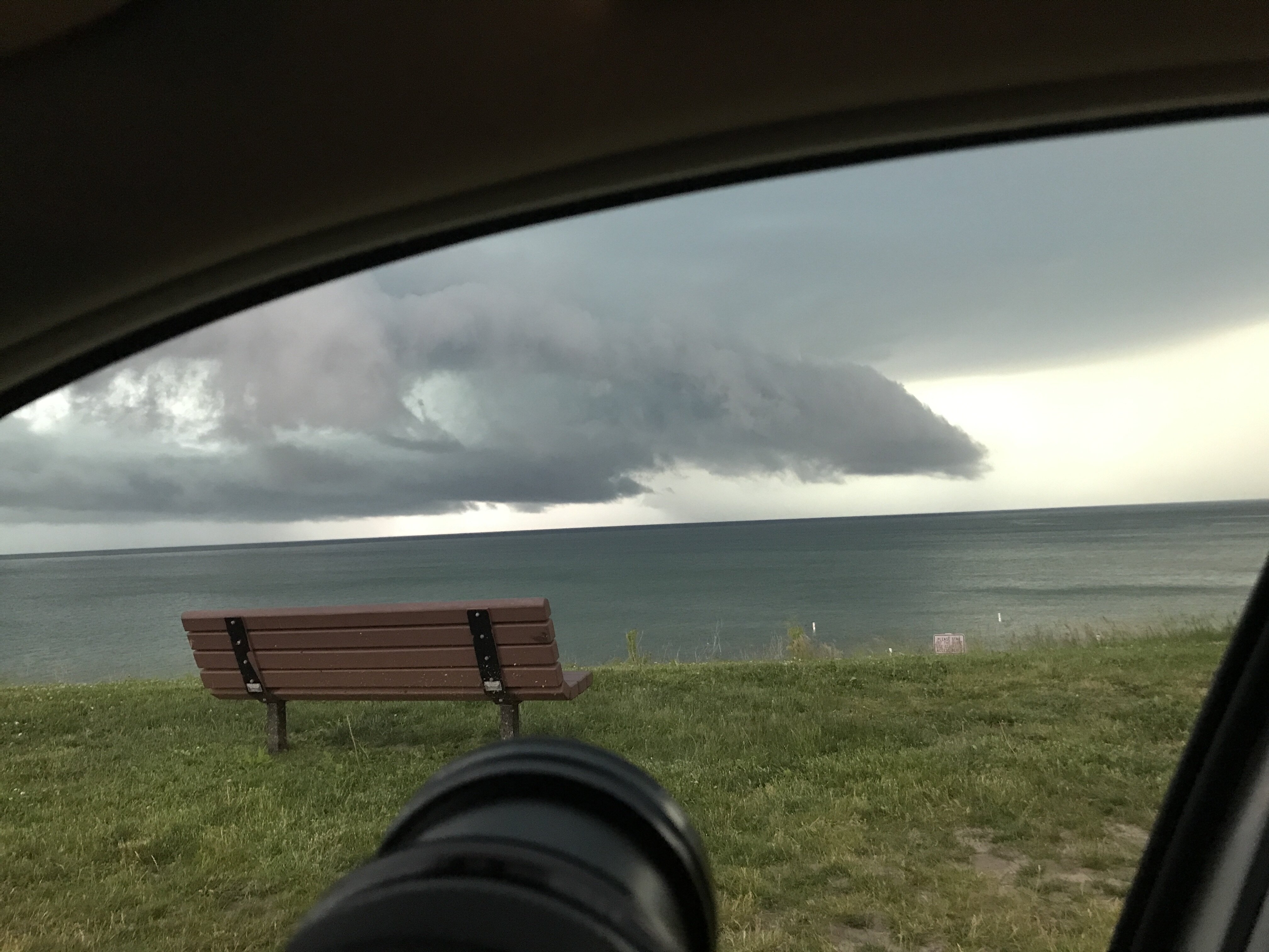
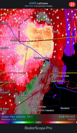
That is a mean looking rear-inflow jet. This one might be even worse than the 2020 Iowa one. Don't know how built up the area is. It's more sparse to the west. -
2022 Short/Medium Range Severe Weather Discussion
frostfern replied to Chicago Storm's topic in Lakes/Ohio Valley
Can someone make a new thread for this event? Move my posts to it? I'm not good at this stuff. -
2022 Short/Medium Range Severe Weather Discussion
frostfern replied to Chicago Storm's topic in Lakes/Ohio Valley
Derecho forming... 100 mph rear inflow. Scary.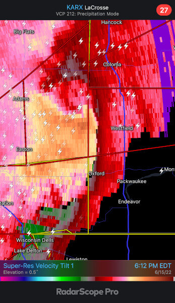
-
2022 Short/Medium Range Severe Weather Discussion
frostfern replied to Chicago Storm's topic in Lakes/Ohio Valley
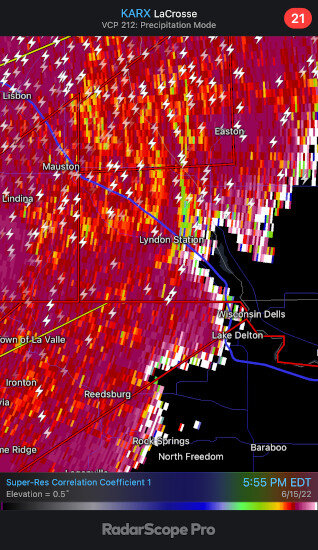
Looks like a pretty high end straight-line wind event crossed I-90 just north of Lyndon Station. There is even a CC drop on the leading edge of the gust. It definitely did some damage.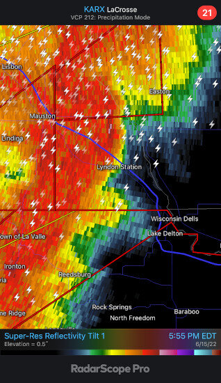
-
2022 Short/Medium Range Severe Weather Discussion
frostfern replied to Chicago Storm's topic in Lakes/Ohio Valley
It's getting messy now, but there's a major straight-line wind event evolving south of the Union Center circulation. -
2022 Short/Medium Range Severe Weather Discussion
frostfern replied to Chicago Storm's topic in Lakes/Ohio Valley
A fourth meso to the south of the others is now tornado warned too. -
2022 Short/Medium Range Severe Weather Discussion
frostfern replied to Chicago Storm's topic in Lakes/Ohio Valley
The middle one looked to be in the high EF-2 / low EF-3 range for a good stretch after crossing the highway. Probably not photogenic though as there was very heavy rain wrapping around on all sides. -
2022 Short/Medium Range Severe Weather Discussion
frostfern replied to Chicago Storm's topic in Lakes/Ohio Valley
Nasty rain-wrapped tornadoes. -
Summer 2022 Medium/Long Range Discussion
frostfern replied to Chicago Storm's topic in Lakes/Ohio Valley
Boo. -
2022 Short/Medium Range Severe Weather Discussion
frostfern replied to Chicago Storm's topic in Lakes/Ohio Valley
I think it will be one of those broken lines where everyone gets outflow gusts but not everyone gets rain. -
They dewpoint is down from around hanging around 80 all evening yesterday to dry crispy 72 this morning.
-
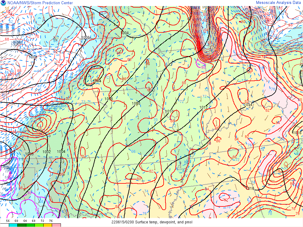
That band of pooled 76-80 dewpoints along the warm front has been rather stagnant. There's been a real soup-zone wedged between the warm/stationary front to the NE and lake marine layer to the west. 14 21:53 SE 10 10.00 Fair CLR 84 78 82% NA 95 29.84 1009.9 14 20:53 SE 10 10.00 A Few Clouds FEW045 86 78 77% NA 98 29.84 1010.0 14 19:53 SE 13 10.00 Partly Cloudy FEW045 SCT250 88 78 90 83 73% NA 102 29.83 1009.6 14 18:53 E 10 10.00 Partly Cloudy FEW040 SCT250 90 79 70% NA 106 29.84 1009.8 14 17:53 E 12 10.00 Partly Cloudy FEW030 SCT250 90 79 70% NA 106 29.85 1010.2 14 16:53 E 13 10.00 A Few Clouds FEW030 89 78 70% NA 103 29.87 1010.8 14 15:53 E 12 10.00 A Few Clouds FEW030 88 77 70% NA 100 29.88 1011.2 14 14:53 SE 10 10.00 A Few Clouds FEW030 86 76 72% NA 96 29.89 1011.4 Kind of looking forward to a toastier heat tomorrow honestly. Just tired of getting soaking wet with perspiration every time I move outside. It just makes me feel so gross. I get the feeling whatever rain and storms try to move SE tomorrow evening will be shitting the bed right on my doorstep, but the outflow breeze SHOULD get here.
-
I remember a few 78 dewpoint days in July in the 2000s. Also a few muggy days with upper 70s dewpoints the past couple years. I just don't really remember it happening before June 15 IMBY. The 1995 heatwave was extremely humid here with a peak dewpoint around 81 or 82 and temperatures in the upper 90s, but that was mid July.
-
90/79 feels worse than 100/65 to me. The soup just makes me feel suffocated. Don't know how the heat index would compare even.
-
Yea. It just feels like there's quite a big difference between 72 and 79. Even between 75 and 79 honestly. The dewpoint is currently 79 and it's been sitting there for over three hours now. It's been 75 or higher all afternoon. Hope it goes down tonight. The air quality is just oppressive right now. There's a lot of pollen too, and ozone, and particulate pollution.
-
That one the extreme humidity didn't make it quite this far north though. The temperature here is nowhere near record territory, but the dewpoint is getting really close to 80 degrees right now. It seems the lake breeze is really pooling the steam here. I have NEVER seen an 80 degree dewpoint before in June. I might be wrong, but I only recall this kind of humid airmass in July. As a Michigander this is just incredibly oppressive. Stepping outside feels like walking into a washcloth run under hot water. I'm just not built for this. I don't think I'd survive more than a few hours outside.
-
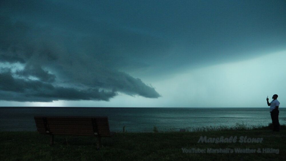
No wonder it looked like a volcanic eruption plume. I wonder where the record would be for the tallest cloud. Tropical cyclones in the strengthening stage often have the highest uniform cloud tops, but there is little or no overshoot. I have heard that supercells that occur over the eastern Indian subcontinent are exceptionally tall.
-
Dewpoint is 78 IMBY. I have never seen this before in June.
-
It's really unusual for these mid-upper 70s dewpoints to get into Michigan in mid-June. That stuff usually stays down in Iowa/Illinois this time of year. If we are already getting this humid in the middle June, I kind of dread late July.
-
I heard that type of thunder while chasing a hailer in Allegan County, MI on April 7, 2020. It was after dark and there were almost no breaks in the lighting. It was a constant strobe. That was after dark though. It would be amazing to see video of that Chi metro cell from the air. If any planes were coming into O'Hare they would be circling waiting for it to move. Sometimes you see more lighting from a distance, or even from the air, as a thick low updraft base tends to obscure a lot of the intracloud lighting. It's always really hard to see the full structure of a beast HP cell with a super low base just because it's so big and low to the ground.
-
The picture is just a thumbnail. Click here to see the timelapse.
-
Its frustrating how the most significant severe events near me have targeted unchaseable zones and populated areas. First Gaylord Michigan, then metro Chicago.
-
Maybe the thing that saved us from a sig-tor event was less impressive wind at the anvil level compared to the mid level. With such high dewpoints you get a lot of precip loading to overcome. With such high echo tops a stronger wind at 8-12 km would push more precip out ahead of the meso. 70-80 rfd downdrafts indicate the meso is chocked with a lot of precipitation.
-
Is that a CB anvil or a volcanic eruption column! The symmetry is so odd for a severe weather environment with high shear. Absolute beast.