frostfern
-
Posts
2,267 -
Joined
-
Last visited
Content Type
Profiles
Blogs
Forums
American Weather
Media Demo
Store
Gallery
Everything posted by frostfern
-
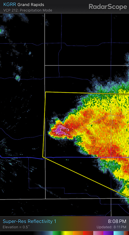
I just got a massive anvil bolt from the blue way up in GRR. Boy it shook the ground hard. It's barely even sprinkling.
-
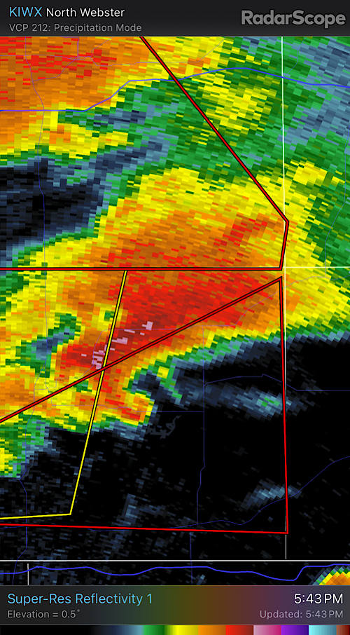
Classic hook.
-
-
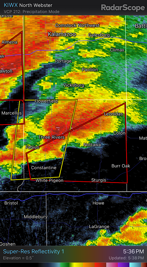
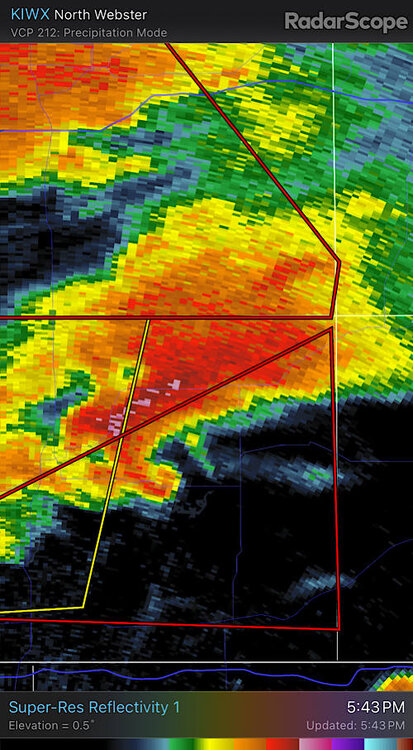
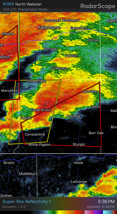
If I were chasing I'd be watching that Three Rivers cell. It's a bit more isolated than the one to the north.
-
That cell near Three Rivers is in a good environment.
-
Looks like there was a brief tornado between Dowagiac and Decatur MI. It's messy looking though. Huge rain wrapped blob.
-
That tornado warned circulation heading towards Dowagiac MI is getting stronger. Hint of CC drop in last scan.
-
Storms actually missed north yesterday. There was some decent hail near Ludington. This just isn't a Great Lakes setup though. It's a plains setup. Best bet for stronger convection farther north and east looks to be next week Thursday. Still uncertainty though. Still way better pattern than last year at this time when there were hardly any storms anywhere in the US. Keeping my fingers crossed there is no blocking again this May. That just killed spring storm season last year.
-
The sun is out and its nice and humid. I can feel the warm front inching back north.
-
Hoping a train sets up at some point with this pattern. Nice one over northern lower at this point. Models showing mostly boring stratiform for here though. EML is all eaten up by time the front is nearby.
-

2024 Short/Medium Range Severe Weather Discussion
frostfern replied to Chicago Storm's topic in Lakes/Ohio Valley
Not really, but thanks. No damage reports, so it was a weak EF0 at best (doubt it gets any confirmation). The hail, well that definitely over-performed. The sun wasn’t even out most of the day so I wasn’t even expecting to hear thunder. It’s impressive to get severe hail with dewpoints in the 40s. It’s more common at high altitudes, like Colorado. -
Tornado warned mini-supercell just to my south. Sirens went off. Too bad its dark.
-
2024 Short/Medium Range Severe Weather Discussion
frostfern replied to Chicago Storm's topic in Lakes/Ohio Valley

-
Rotating cell.

-
Best lightning bolts since Feb 7.
-
Its got a little rotation on it. Kinda high based though.
-
Nice rumbler off to my north. Heavy graupel / small hail producer.
-
Might be a nice triple-point moving through here tomorrow. I hope the trend is to slow it down.
-
Possible up your way. The next system looks to immediately melt it all here. Kind of useless this time of year. I’ll take it now if April can flip back to warm / thunder.
-
That's weird because I've had the opposite experience a few years ago. I thought maybe they went off again because another warning was issued for areas farther east and I just happened to be in the overlap (though the event, which was ruled a localized straight line wind event, actually missed me by about 5 miles). Turning them on to indicate the risk is over would make absolutely no sense to me though. I figured it had to do with overlapping warnings issued in succession.
-
Wow. Glad you're okay. Hail damage sounds bad. The 2-3 times I've heard the sirens they went off after the storm had passed and all the risk was over. Not always much you can do with brief spin-ups, but the warning was issued like 8 minutes after the first CC drop scan with that one tornado last August, which was pretty bad.
-
Anyone from Battle Creek up and have internet connection?
-
It's hard to tell how strong it is. It's far from the radar and I can't distinguish side lobe artifacts from actual wind speeds. I don't see a huge CC drop, but its not so close to the radar.
-
I really should not have dismissed the possibility of tornadoes at night. Rotation headed straight for Battle Creek is nasty.
-
BULLETIN - EAS ACTIVATION REQUESTED Tornado Warning National Weather Service Grand Rapids MI 1201 AM EST Wed Feb 28 2024 The National Weather Service in Grand Rapids has issued a * Tornado Warning for... Northern Calhoun County in south central Michigan... * Until 100 AM EST. * At 1201 AM EST, a severe thunderstorm capable of producing a tornado was located near Galesburg, or 9 miles southwest of Battle Creek, moving east at 35 mph. HAZARD...Tornado. SOURCE...Radar indicated rotation. IMPACT...Flying debris will be dangerous to those caught without shelter. Mobile homes will be damaged or destroyed. Damage to roofs, windows, and vehicles will occur. Tree damage is likely. * This dangerous storm will be near... Battle Creek, Springfield, and Level Park-Oak Park around 1205 AM EST. Brownlee Park around 1210 AM EST. Other locations in the path of this tornadic thunderstorm include Marshall. PRECAUTIONARY/PREPAREDNESS ACTIONS... TAKE COVER NOW! Move to a basement or an interior room on the lowest floor of a sturdy building. Avoid windows. If you are outdoors, in a mobile home, or in a vehicle, move to the closest substantial shelter and protect yourself from flying debris. Tornadoes are extremely difficult to see and confirm at night. Do not wait to see or hear the tornado. TAKE COVER NOW! && LAT...LON 4242 8530 4242 8472 4225 8472 4217 8529 TIME...MOT...LOC 0501Z 254DEG 32KT 4226 8540 TORNADO...RADAR INDICATED MAX HAIL SIZE...<.75 IN $$ NJJ