


Mailman
-
Posts
1,653 -
Joined
-
Last visited
Content Type
Profiles
Blogs
Forums
American Weather
Media Demo
Store
Gallery
Everything posted by Mailman
-

Pittsburgh/Western PA WINTER ‘25/‘26
Mailman replied to Burghblizz's topic in Upstate New York/Pennsylvania
Yep, Even an evening bump for down this way. -
Pittsburgh/Western PA WINTER ‘25/‘26
Mailman replied to Burghblizz's topic in Upstate New York/Pennsylvania
-
Pittsburgh PA Fall 2025 Thread
Mailman replied to TheClimateChanger's topic in Upstate New York/Pennsylvania
Most models and ensemble solutions have come into agreement more closely on the precise low track through coastal GA/SC and directly up the East Coast, positioning us on the far northern edge. This track places the transition zone along and south of I-70 and along and east of the Ohio river. Areas north and west of this have a better shot to remain all snow and therefore have a higher chance of seeing 2-4" snowfall totals. South and east of this, precip types may be an issue for snowfall accumulation with a wintry mix more likely in this region. Probabilities for Advisory level snow have climbed across much of the region (save for the Mon Valley) compared to 24 hours ago. Probabilities for Warning level snow remain largely between 10-20% at their highest. Snowfall rates of 1"/hour seem possible in the heaviest snowfall, likely during the predawn hours of Tuesday morning. These rates peak in several stripes running SW to NE across the region, highlighting embedded heavier bands in the stratiform snow. Neighborhood probabilities for 1"/hour rates peak as high as 60-80% in SE Ohio near the I-70 corridor, but are at least 20-30% across much of the region. Stout 850mb WAA racing up the spine of the Appalachians points towards the possibility of freezing rain in the Mon Valley and eastern ridges early Tuesday morning. These chances remain highest in our WV ridges, where the best WAA will be. Further west towards the Ohio river, there could still could be freezing rain if the WAA over performs but current model soundings point towards a period of melting snow or sleet. Ice accumulations of a glaze up to a few hundredths could be possible by Tuesday morning, highest in the WV ridges. At this time a Winter Weather Advisory looks likely for much of the area for accumulating snowfall and then perhaps another in the ridges for possible ice. We could end up in a situation where the only areas that do not need a Winter Weather Advisory would be portions of the Mon Valley, where snowfall totals will be kept in check by low SLRs/rainfall and freezing rain chances are lower than just east in the ridges. No matter the headline decision, the Tuesday morning commute could be a messy and potentially dangerous one across the region. Please allow for extra time to reach your destinations and we urge extra caution on area roadways. -
Pittsburgh PA Fall 2025 Thread
Mailman replied to TheClimateChanger's topic in Upstate New York/Pennsylvania
First respectable snow within five days, it seems. -
Pittsburgh PA Fall 2025 Thread
Mailman replied to TheClimateChanger's topic in Upstate New York/Pennsylvania
Some areas down this way have been getting crushed with rain the last couple hours. Surprised not to see any posts from our Chalk Hill poster. -
-
This weather is terrible.
-
Just rain down here.
-
Pretty weak down here, but I'm not complaining.
-
Still three days away... .LONG TERM /FRIDAY NIGHT THROUGH TUESDAY/... KEY MESSAGES: - Weekend severe weather potential and flooding potential. - A brief cooldown Monday, with a warmup into mid-week. ------------------------------------------------------------------- There is increasing confidence in the next disturbance passing through this weekend. The most likely timing remains, Saturday for the warm front, with a strong pressure gradient Saturday afternoon with enhanced low level flow in the warm sector. This will need to continue to be monitored for severe development, with ensemble plumes fairly confident on buoyancy, but unsure on just how much. This might suggest a primary threat of damaging winds. The main cold front is most likely to pass late Saturday into early Sunday. Rainfall amounts are quite variable, between 0.5 and 1.5 inches between the 25th and 75th percentile. Marginal flooding conditions are also possible as the cold front slowly moves through. Synoptic winds are also forecast at 20 to 30 mph (25th to 75th percentile). Behind the cold front, a brief cool down to near-normal is expected with moderate confidence, followed by a warm-up back above normal by mid-week.
-
Pittsburgh/Western PA Winter 2024-2025 Thread
Mailman replied to Rd9108's topic in Upstate New York/Pennsylvania
GFS out of nowhere. -
Pittsburgh/Western PA Winter 2024-2025 Thread
Mailman replied to Rd9108's topic in Upstate New York/Pennsylvania
-
Pittsburgh/Western PA Winter 2024-2025 Thread
Mailman replied to Rd9108's topic in Upstate New York/Pennsylvania
Didn't know thunderstorms were on the menu for today. -
Pittsburgh/Western PA Winter 2024-2025 Thread
Mailman replied to Rd9108's topic in Upstate New York/Pennsylvania
Try to cheer you folks up...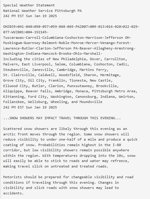
-
Pittsburgh/Western PA Winter 2024-2025 Thread
Mailman replied to Rd9108's topic in Upstate New York/Pennsylvania
Yeah.. it was coming down at a good clip here about 10 minutes ago. -
Pittsburgh/Western PA Winter 2024-2025 Thread
Mailman replied to Rd9108's topic in Upstate New York/Pennsylvania
Couple inches out there. Not bad. -
Pittsburgh/Western PA Winter 2024-2025 Thread
Mailman replied to Rd9108's topic in Upstate New York/Pennsylvania
Can report light snow here, as well. -
Pittsburgh/Western PA Winter 2024-2025 Thread
Mailman replied to Rd9108's topic in Upstate New York/Pennsylvania
Ended up with 5.5". Can't complain. -
Pittsburgh/Western PA Winter 2024-2025 Thread
Mailman replied to Rd9108's topic in Upstate New York/Pennsylvania
I was at 4.5" about an hour ago. -
Pittsburgh/Western PA Winter 2024-2025 Thread
Mailman replied to Rd9108's topic in Upstate New York/Pennsylvania
I'd say close to 3" here. -
Pittsburgh/Western PA Winter 2024-2025 Thread
Mailman replied to Rd9108's topic in Upstate New York/Pennsylvania
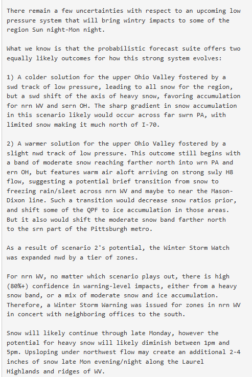
-
Pittsburgh/Western PA Winter 2024-2025 Thread
Mailman replied to Rd9108's topic in Upstate New York/Pennsylvania
-
Pittsburgh/Western PA Winter 2024-2025 Thread
Mailman replied to Rd9108's topic in Upstate New York/Pennsylvania
Trends aren't out friends. -
Pittsburgh/Western PA Winter 2024-2025 Thread
Mailman replied to Rd9108's topic in Upstate New York/Pennsylvania
Ah yeah.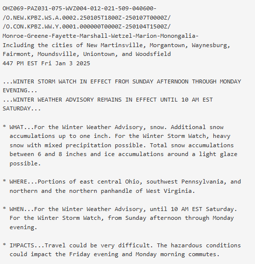
-
Pittsburgh/Western PA Winter 2024-2025 Thread
Mailman replied to Rd9108's topic in Upstate New York/Pennsylvania
GFS has the warm tongue looming on Monday.


