Mailman
-
Posts
1,650 -
Joined
-
Last visited
Content Type
Profiles
Blogs
Forums
American Weather
Media Demo
Store
Gallery
Everything posted by Mailman
-

Pittsburgh/Western PA WINTER ‘25/‘26
Mailman replied to Burghblizz's topic in Upstate New York/Pennsylvania
-
Pittsburgh/Western PA WINTER ‘25/‘26
Mailman replied to Burghblizz's topic in Upstate New York/Pennsylvania
Latest map: -
Pittsburgh/Western PA WINTER ‘25/‘26
Mailman replied to Burghblizz's topic in Upstate New York/Pennsylvania
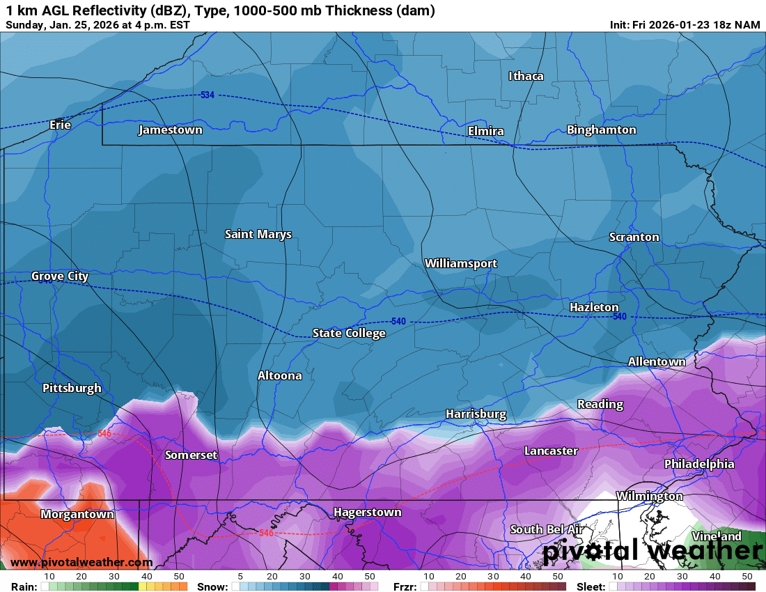
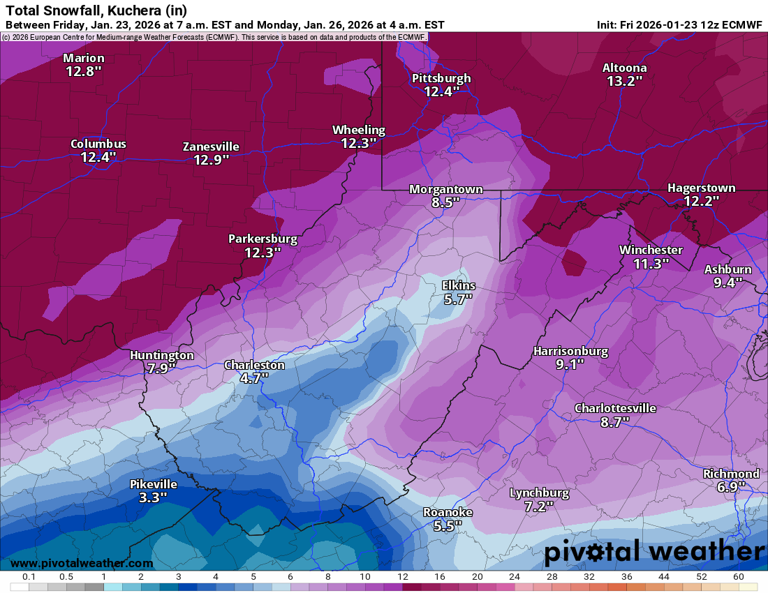
.DISCUSSION... KEY MESSAGE 1... A major winter storm is expected to impact the region late this evening through early Monday morning. A Winter Storm Warning remains in effect across the area due to the potential for historic snowfall totals ranging from 9 to 15 inches. With cold air firmly in place early this morning into the afternoon-- temperatures in the single digits--confidence is high that precipitation will begin as snow and remain dry, with snow ratios near 18:1 through early Sunday morning. As the system approaches, light to moderate snowfall is expected to develop south of I-70 between 8pm and midnight tonight. Farther north, including areas near and north of Pittsburgh, light to moderate snow will likely begin between midnight and 4am Sunday. As frontogenesis strengthens ahead of a robust low-level jet near daybreak Sunday, with 850mb winds of 60-70kt from the southwest, snowfall rates are expected to increase across portions of the area as snow bands develop. High-resolution guidance shows increasing probabilities of 1 to 1.5 inches per hour snowfall rates with this synoptic feature, persisting into late Sunday night as the surface low tracks into western Pennsylvania. Travel between 10am Sunday to 10pm Sunday will likely be very difficult to impossible across the region. Areas north of I-70 are expected to remain predominantly snow throughout the duration of the storm. However, locations southeast of Pittsburgh, including Preston, Tucker, and Fayette counties, will likely experience a wintry mix of sleet and freezing rain, resulting in periods of ice accumulation atop existing snow. The combination of heavy snow and ice may lead to power outages and down tree branches in this region. -
Pittsburgh/Western PA WINTER ‘25/‘26
Mailman replied to Burghblizz's topic in Upstate New York/Pennsylvania
-
Pittsburgh/Western PA WINTER ‘25/‘26
Mailman replied to Burghblizz's topic in Upstate New York/Pennsylvania
I know I'll be mixing. I just hope it doesn't last very long. -
Pittsburgh/Western PA WINTER ‘25/‘26
Mailman replied to Burghblizz's topic in Upstate New York/Pennsylvania
-
Pittsburgh/Western PA WINTER ‘25/‘26
Mailman replied to Burghblizz's topic in Upstate New York/Pennsylvania
-
Pittsburgh/Western PA WINTER ‘25/‘26
Mailman replied to Burghblizz's topic in Upstate New York/Pennsylvania
If anything, you have to admire the consistency. -
Pittsburgh/Western PA WINTER ‘25/‘26
Mailman replied to Burghblizz's topic in Upstate New York/Pennsylvania
I'm going with 9-12" down here. I think the big city gets rocked. 12-15". -
Pittsburgh/Western PA WINTER ‘25/‘26
Mailman replied to Burghblizz's topic in Upstate New York/Pennsylvania
Snowmap is juiced up. -
Pittsburgh/Western PA WINTER ‘25/‘26
Mailman replied to Burghblizz's topic in Upstate New York/Pennsylvania
That wasn't a good start to the 0z suite. ...but it's late in the run HRRR. So, I don't know. -
Pittsburgh/Western PA WINTER ‘25/‘26
Mailman replied to Burghblizz's topic in Upstate New York/Pennsylvania
HRRR has rain in Morgantown Sunday evening. -
Pittsburgh/Western PA WINTER ‘25/‘26
Mailman replied to Burghblizz's topic in Upstate New York/Pennsylvania
DT always does poorly here, but I'll post anyway. -
Pittsburgh/Western PA WINTER ‘25/‘26
Mailman replied to Burghblizz's topic in Upstate New York/Pennsylvania
News stations use it. I know that much. -
Pittsburgh/Western PA WINTER ‘25/‘26
Mailman replied to Burghblizz's topic in Upstate New York/Pennsylvania
I can't speak to the accuracy of the GRAF model. -
Pittsburgh/Western PA WINTER ‘25/‘26
Mailman replied to Burghblizz's topic in Upstate New York/Pennsylvania
Is this from someone you trust or some weenie (like me)? -
Pittsburgh/Western PA WINTER ‘25/‘26
Mailman replied to Burghblizz's topic in Upstate New York/Pennsylvania
Geez.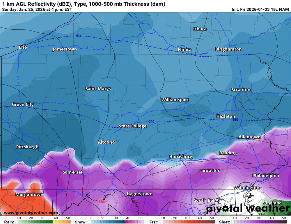
-
Pittsburgh/Western PA WINTER ‘25/‘26
Mailman replied to Burghblizz's topic in Upstate New York/Pennsylvania
-
Pittsburgh/Western PA WINTER ‘25/‘26
Mailman replied to Burghblizz's topic in Upstate New York/Pennsylvania
18z HRRR looks real promising. -
Pittsburgh/Western PA WINTER ‘25/‘26
Mailman replied to Burghblizz's topic in Upstate New York/Pennsylvania
.DISCUSSION... KEY MESSAGE 1... The Winter Storm Warning continues. Significant snow accumulations are still forecast, but sleet and freezing rain chances have increased in the ridges, particularly in northern West Virginia. The large-scale pattern as advertised by the model suite has not changed significantly with the upcoming winter storm. An Arctic cold front currently dropping across the region with a thin band of snow showers will have the main impact of introducing a very cold air mass back to the region. Upstream, shortwaves originating over the northern Plains and southern Rockies will begin to phase as they approach the Mississippi River Valley Sunday/Sunday night. Surface low pressure develops along the Gulf Coast Saturday night and lifts northeastward on Sunday, eventually handing off to a developing Atlantic Coast low by Monday morning. Inverted troughing pokes northward into the Middle and Upper Ohio Valley Saturday night and Sunday. On the eastern side of this, southeast flow and a decent southerly 850mb jet will support warming aloft mainly to the south and east of Pittsburgh on Sunday. With increased confidence in this, greater coverage and amounts of freezing rain and sleet have been introduced. This is particularly true in the higher terrain of northern West Virginia, where one to two tenths of ice accretion may occur, along with a period of sleet. This has cut down the snow accumulations in this region. Overall, moisture and lift remain impressive overall with this system. We still expect a coupled upper jet structure, layered frontogenesis, and the inverted trough to support strong lift. Precipitable water is forecast to reach around the 90th percentile level as compared to late January climatology as well. So, overall liquid equivalent totals of 1 to 2 inches are still a good bet. With the further northward extent of warm air aloft, snow-to-liquid ratios have trended down slightly, which was the main factor in lowering storm total snowfall amounts. Nevertheless, a widespread significant snowfall is still forecast across the region with high confidence. Here are the latest 48-hour ensemble-based probabilities for 48-hour snow totals through 7 AM Monday. They are similar to previous model runs overall, but probabilities for the higher- end accumulations have decreased slightly: 15":10-50% 12":50-80% 8": 75-95% 6": 85-100% 4": 95-100% Given the lower expected SLRs, there remains a decent chance of a heavier, wetter snow, especially near and south of Pittsburgh. Also, given low SLRs and increased chances for freezing rain, the chance of power outage impacts is increasing in the higher elevations, particularly in northern West Virginia. We will need to continue to monitor precipitation-type trends and adjust accordingly. However, there is high confidence in Winter Storm Warning-level impacts in any case. The timing of the heaviest snow still appears to be during Sunday morning south of I-70, and late morning Sunday through Sunday evening north of I-70. Cold northwesterly flow and the crossing parent upper trough could result in lingering snow into Monday. Continue to monitor the latest forecasts as this system approaches, as widespread impacts to travel and daily life are highly likely Sunday into Monday. -
Pittsburgh/Western PA WINTER ‘25/‘26
Mailman replied to Burghblizz's topic in Upstate New York/Pennsylvania
-
Pittsburgh/Western PA WINTER ‘25/‘26
Mailman replied to Burghblizz's topic in Upstate New York/Pennsylvania
-
Pittsburgh/Western PA WINTER ‘25/‘26
Mailman replied to Burghblizz's topic in Upstate New York/Pennsylvania
Guh. -
Pittsburgh/Western PA WINTER ‘25/‘26
Mailman replied to Burghblizz's topic in Upstate New York/Pennsylvania

-
Pittsburgh/Western PA WINTER ‘25/‘26
Mailman replied to Burghblizz's topic in Upstate New York/Pennsylvania
Just wanted to say it's been fun tracking this thing with everyone the last several days. Hope everyone gets to cash in. Also... glad no one on here had a meltdown at any point. I remember we had one poster on here a few years ago. He(?) was wound up good and proper.