Mailman
-
Posts
1,650 -
Joined
-
Last visited
Content Type
Profiles
Blogs
Forums
American Weather
Media Demo
Store
Gallery
Everything posted by Mailman
-

Pittsburgh/Western PA WINTER ‘25/‘26
Mailman replied to Burghblizz's topic in Upstate New York/Pennsylvania
Brownsville acting as "Little Round Top" for the mix line. -
Pittsburgh/Western PA WINTER ‘25/‘26
Mailman replied to Burghblizz's topic in Upstate New York/Pennsylvania
HRRR has mix retreating to the south now. I love it! -
Pittsburgh/Western PA WINTER ‘25/‘26
Mailman replied to Burghblizz's topic in Upstate New York/Pennsylvania
Back to snow (for now). -
Pittsburgh/Western PA WINTER ‘25/‘26
Mailman replied to Burghblizz's topic in Upstate New York/Pennsylvania
The freezing rain has arrived. -
Pittsburgh/Western PA WINTER ‘25/‘26
Mailman replied to Burghblizz's topic in Upstate New York/Pennsylvania
-
Pittsburgh/Western PA WINTER ‘25/‘26
Mailman replied to Burghblizz's topic in Upstate New York/Pennsylvania
Getting close.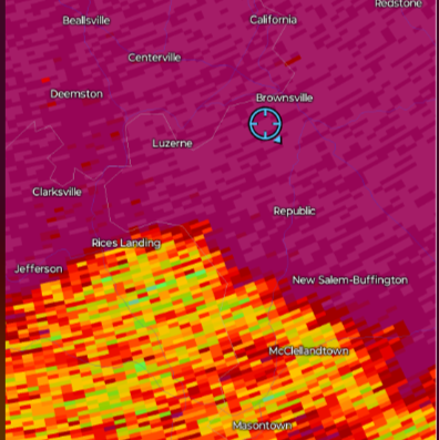
-
Pittsburgh/Western PA WINTER ‘25/‘26
Mailman replied to Burghblizz's topic in Upstate New York/Pennsylvania
Snow slowing down now. -
Pittsburgh/Western PA WINTER ‘25/‘26
Mailman replied to Burghblizz's topic in Upstate New York/Pennsylvania
Gonna be seeing BIG problems down this way along the bottom of the mountain. Downsloping + ice. -
Pittsburgh/Western PA WINTER ‘25/‘26
Mailman replied to Burghblizz's topic in Upstate New York/Pennsylvania
Freezing rain reported in Morgantown. Figured it was a matter of time. -
Pittsburgh/Western PA WINTER ‘25/‘26
Mailman replied to Burghblizz's topic in Upstate New York/Pennsylvania
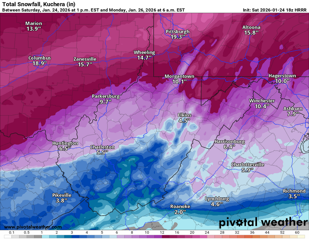
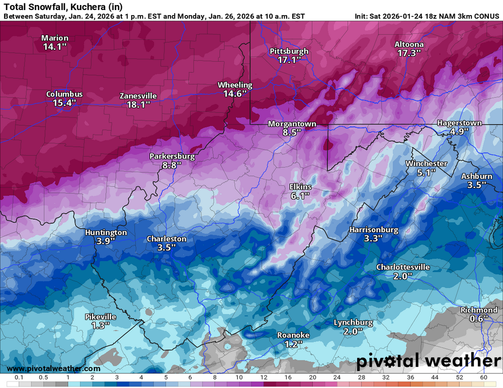
Pushing 8" here, I believe. -
Pittsburgh/Western PA WINTER ‘25/‘26
Mailman replied to Burghblizz's topic in Upstate New York/Pennsylvania
-
Pittsburgh/Western PA WINTER ‘25/‘26
Mailman replied to Burghblizz's topic in Upstate New York/Pennsylvania
Up to like 7-7.5" here. Wow. -
Pittsburgh/Western PA WINTER ‘25/‘26
Mailman replied to Burghblizz's topic in Upstate New York/Pennsylvania
Light snow in Morgantown, as of 10:53. Will be keeping an eye on this one. https://forecast.weather.gov/data/obhistory/KMGW.html -
Pittsburgh/Western PA WINTER ‘25/‘26
Mailman replied to Burghblizz's topic in Upstate New York/Pennsylvania
What are the obs in Morgantown? -
Pittsburgh/Western PA WINTER ‘25/‘26
Mailman replied to Burghblizz's topic in Upstate New York/Pennsylvania
Still snow here. -
Pittsburgh/Western PA WINTER ‘25/‘26
Mailman replied to Burghblizz's topic in Upstate New York/Pennsylvania
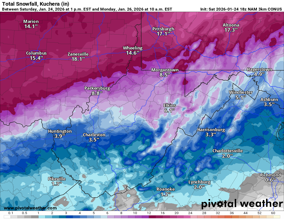
Totals came up. -
Pittsburgh/Western PA WINTER ‘25/‘26
Mailman replied to Burghblizz's topic in Upstate New York/Pennsylvania
I hear that it's snowing in Seven Springs. -
Pittsburgh/Western PA WINTER ‘25/‘26
Mailman replied to Burghblizz's topic in Upstate New York/Pennsylvania
-
Pittsburgh/Western PA WINTER ‘25/‘26
Mailman replied to Burghblizz's topic in Upstate New York/Pennsylvania
The WTOD signature down here seems to be slowly going away. But... I have to see it in real time not to believe it. -
Pittsburgh/Western PA WINTER ‘25/‘26
Mailman replied to Burghblizz's topic in Upstate New York/Pennsylvania
Perhaps wishful thinking on my part, but starting to see some late positive trends. -
Pittsburgh/Western PA WINTER ‘25/‘26
Mailman replied to Burghblizz's topic in Upstate New York/Pennsylvania
Quicker transfer at 18z? That's what we want. -
Pittsburgh/Western PA WINTER ‘25/‘26
Mailman replied to Burghblizz's topic in Upstate New York/Pennsylvania
GFS cuts back on the mixing from 12z. -
Pittsburgh/Western PA WINTER ‘25/‘26
Mailman replied to Burghblizz's topic in Upstate New York/Pennsylvania
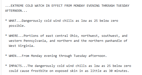
US National Weather Service Pittsburgh PA tronSposde90mimi9i6ta5uflhlfuf7ama6ggffgmm58l54507301f0tmglc · One thing we are monitoring is a "warm nose" or layer of warmer air that could change snow characteristics or even precipitation-type near or south of Pittsburgh. The first image highlights that uncertainty and how the forecast changes if it advances farther northward than expected. At this time, areas near and south of Morgantown are likely to see warm air create a period of sleet and/or freezing rain during the day Sunday. Even with lower amounts of snow, this mix of snow + ice + sleet can still impact road conditions and result in power outages. There remain scenarios that this warm layer works farther northward. What does that mean? If this does occur (a lower probability to do so), these areas may see slightly lower but still impactful amounts of heavier/wetter snow that is harder to deal with. The second graphic highlights how this event may change with time for a place like Pittsburgh: dry, fluffy snow to start becoming wet/heavy during the day Sunday before transitioning to dry/fluffy Monday morning. This is why simple temperature changes can create more nuance to a forecast that a “storm total snow” may not fully describe. Our office works hard to communicate all these aspects with regional partners so they can best navigate the challenges winter storms create. -
Pittsburgh/Western PA WINTER ‘25/‘26
Mailman replied to Burghblizz's topic in Upstate New York/Pennsylvania
-
Pittsburgh/Western PA WINTER ‘25/‘26
Mailman replied to Burghblizz's topic in Upstate New York/Pennsylvania