Mailman
-
Posts
1,651 -
Joined
-
Last visited
Content Type
Profiles
Blogs
Forums
American Weather
Media Demo
Store
Gallery
Everything posted by Mailman
-

Western Pa / Pittsburgh area Winter Discussion ❄️☃️
Mailman replied to north pgh's topic in Upstate New York/Pennsylvania
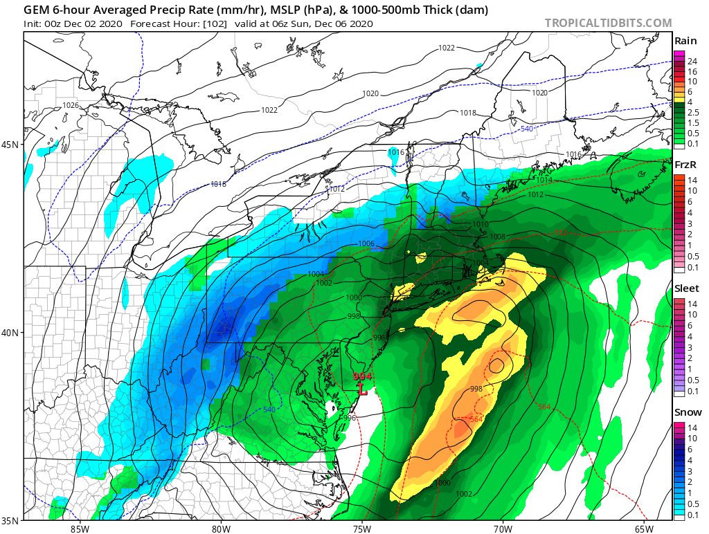
Still plenty of time to go. Not sure if I'd wanna be in the bullseye at this point or not. -
Western Pa / Pittsburgh area Winter Discussion ❄️☃️
Mailman replied to north pgh's topic in Upstate New York/Pennsylvania
Apparently, there were a lot of good hits on the Euro ensembles. 15-25% chance of a foot in our area. I'll take that. 50-60% for 6+. Can live with that, too. -
Western Pa / Pittsburgh area Winter Discussion ❄️☃️
Mailman replied to north pgh's topic in Upstate New York/Pennsylvania
Things seem to be looking a bit better for the area, at this time. -
Western Pa / Pittsburgh area Winter Discussion ❄️☃️
Mailman replied to north pgh's topic in Upstate New York/Pennsylvania
Looks like most of the excitement next week will be off to the east. -
Western Pa / Pittsburgh area Winter Discussion ❄️☃️
Mailman replied to north pgh's topic in Upstate New York/Pennsylvania
4" here. So right on the higher end of what was projected for me. I'll take that on December 1st any year.
-
Western Pa / Pittsburgh area Winter Discussion ❄️☃️
Mailman replied to north pgh's topic in Upstate New York/Pennsylvania
Approaching a modest 3" here. -
Western Pa / Pittsburgh area Winter Discussion ❄️☃️
Mailman replied to north pgh's topic in Upstate New York/Pennsylvania
Everyone under an advisory now. -
Western Pa / Pittsburgh area Winter Discussion ❄️☃️
Mailman replied to north pgh's topic in Upstate New York/Pennsylvania
PBZ ups totals... -
Western Pa / Pittsburgh area Winter Discussion ❄️☃️
Mailman replied to north pgh's topic in Upstate New York/Pennsylvania
-
Western Pa / Pittsburgh area Winter Discussion ❄️☃️
Mailman replied to north pgh's topic in Upstate New York/Pennsylvania
Looks like first accumulating snowfall on Tuesday. I consider anything in November/December as bonus snow for the season. -
Pittsburgh PA Spring and Summer 2020 Thread
Mailman replied to meatwad's topic in Upstate New York/Pennsylvania
Special Weather Statement National Weather Service Pittsburgh PA 434 PM EST Tue Nov 17 2020 OHZ041-PAZ007>009-013>016-020>023-073>076-WVZ510>514-180015- Columbiana-Mercer-Venango-Forest-Lawrence-Butler-Clarion- Jefferson PA-Beaver-Allegheny-Armstrong-Indiana-Westmoreland- Westmoreland Ridges-Fayette-Fayette Ridges- Ridges of Eastern Monongalia and Northwestern Preston-Preston- Eastern Preston-Western Tucker-Eastern Tucker- Including the cities of East Liverpool, Salem, Columbiana, Sharon, Hermitage, Grove City, Oil City, Franklin, Tionesta, New Castle, Ellwood City, Butler, Clarion, Punxsutawney, Brookville, Aliquippa, Beaver Falls, Ambridge, Monaca, Pittsburgh Metro Area, Kittanning, Ford City, Indiana, Murrysville, Greensburg, New Kensington, Lower Burrell, Latrobe, Monessen, Ligonier, Donegal, Uniontown, Champion, Ohiopyle, Coopers Rock, Kingwood, Bruceton Mills, Terra Alta, Rowlesburg, Hazelton, Parsons, Hendricks, Saint George, Davis, Thomas, and Canaan Valley 434 PM EST Tue Nov 17 2020 ...BRIEF HEAVY SNOW SHOWERS INTO THIS EVENING... Brief snow showers into the evening hours may lead to travel disruptions. Visibility reductions to one half mile and wind gusts to 30 MPH are possible in the heavier snow showers. These may also produce a quick coating of snow, especially on bridges and overpasses, and create slick conditions on roads. Motorists are urged to use caution while driving. Lower your speed and increase following distances if you encounter heavy snow. -
Pittsburgh PA Spring and Summer 2020 Thread
Mailman replied to meatwad's topic in Upstate New York/Pennsylvania
Mesoscale Discussion 1372 NWS Storm Prediction Center Norman OK 0119 PM CDT Sat Aug 01 2020 Areas affected...eastern Kentucky...much of Ohio...much of West Virginia...and far southwestern Pennsylvania Concerning...Severe potential...Watch possible Valid 011819Z - 011915Z Probability of Watch Issuance...40 percent SUMMARY...Deepening convection will pose a risk for damaging winds and perhaps a tornado or two through the afternoon. A WW issuance is being considered. DISCUSSION...Convection across eastern Kentucky has gradually deepened and intensified over the past hour, partially in response to lift/ascent associated with a mid-level low over Illinois. These storms are in a moderately buoyant airmass (1500-2500 J/kg MUCAPE), with deep shear of around 25-35 knots marginally favoring loose organization. Weak low-level flow also favors outflow dominant storms, though some turning/veering with height may support occasional updraft rotation in persistent, cellular convection. An east-to-west oriented warm front located from near DAY to near MRB may also aid in updraft rotation with cells that can favorably interact. The overall scenario suggests potential for occasional wind damage and perhaps a tornado or two with stronger convection. The nature of the threat may become substantial enough to require a WW issuance over the next couple of hours. Convective trends are being monitored. ..Cook/Bunting.. 08/01/2020 -
Pittsburgh PA Spring and Summer 2020 Thread
Mailman replied to meatwad's topic in Upstate New York/Pennsylvania
Mesoscale Discussion 1242 NWS Storm Prediction Center Norman OK 0251 PM CDT Thu Jul 16 2020 Areas affected...Northwest OH...Western PA...Northern WV Panhandle...Western NY Concerning...Severe Thunderstorm Watch 378... Valid 161951Z - 162115Z The severe weather threat for Severe Thunderstorm Watch 378 continues. SUMMARY...Threat for strong to severe storms capable of damaging wind gusts and a tornado or two continues. DISCUSSION...Broad surface confluence within the warm sector continues to promote widely scattered thunderstorm development. Temperatures across the region have warmed into the mid 80s in the warm sector, with recent mesoanalysis estimating between 1000-1500 J/kg of MLCAPE. Enhanced low-level flow stretches across the warm sector, which is also along the southern edge of the strong mid-level westerlies. Consequently, effective bulk shear decreases from around from 40-45 kt around the western PA/NY border vicinity to 30 kt across western OH. These conditions remain supportive of strong to severe storms. Primary severe threat continues to be damaging wind gusts, although a tornado or two also remains possible. ..Mosier.. 07/16/2020 -
Pittsburgh PA Spring and Summer 2020 Thread
Mailman replied to meatwad's topic in Upstate New York/Pennsylvania
BULLETIN - IMMEDIATE BROADCAST REQUESTED Severe Thunderstorm Warning National Weather Service Pittsburgh PA 527 PM EDT Fri Jul 10 2020 The National Weather Service in Pittsburgh has issued a * Severe Thunderstorm Warning for... Central Fayette County in southwestern Pennsylvania... * Until 600 PM EDT. * At 526 PM EDT, a severe thunderstorm was located near Uniontown, and is nearly stationary. HAZARD...Wind gusts to 60 mph. SOURCE...Radar. IMPACT...Expect damage to trees and power lines, resulting in some power outages. * Locations impacted include... Uniontown... Connellsville... South Connellsville... Fairchance... Dunbar... Vanderbilt... Dawson... Grindstone... New Salem... Chalkhill... Mill Run... PRECAUTIONARY/PREPAREDNESS ACTIONS... Move to an interior room on the lowest floor of a building. Please report severe weather by calling 412-262-1988, posting to the NWS Pittsburgh Facebook page, or using Twitter @NWSPITTSBURGH. -
Pittsburgh PA Spring and Summer 2020 Thread
Mailman replied to meatwad's topic in Upstate New York/Pennsylvania
Mesoscale Discussion 1174 NWS Storm Prediction Center Norman OK 0311 PM CDT Fri Jul 10 2020 Areas affected...Eastern Kentucky...western West Virginia...Eastern Ohio...and far western Pennsylvania Concerning...Severe potential...Watch unlikely Valid 102011Z - 102145Z Probability of Watch Issuance...5 percent SUMMARY...Strong to occasionally severe storms are expected to persist into the early evening hours. Damaging winds remains the primary threat. DISCUSSION...Several rounds of storms have moved across most of Ohio and northern Kentucky this afternoon with scattered wind damage reports. A few severe wind gusts have also been reported. Expanding cloud cover and convective overturning has cooled the boundary layer across most of the region and thus instability has decreased. In addition, dewpoints decrease significantly in central Pennsylvania. Therefore, the cooling boundary layer farther west and the lower moisture ahead of the ongoing activity should lead to gradual overall weakening of these storms. However, there are still a few pockets with upper 80s to lower 90s temperatures in eastern Ohio, eastern Kentucky, and eastern West Virginia where strong instability will still be present. Therefore, a few strong to severe storms are still expected into the early evening hours. ..Bentley/Kerr.. 07/10/2020 -
Pittsburgh PA Spring and Summer 2020 Thread
Mailman replied to meatwad's topic in Upstate New York/Pennsylvania
Confirmed EF2 tornado in Beaver County, I see. -
Pittsburgh PA Spring and Summer 2020 Thread
Mailman replied to meatwad's topic in Upstate New York/Pennsylvania
BULLETIN - IMMEDIATE BROADCAST REQUESTED Severe Thunderstorm Warning National Weather Service Pittsburgh PA 443 PM EDT Thu Jun 4 2020 The National Weather Service in Pittsburgh has issued a * Severe Thunderstorm Warning for... Washington County in southwestern Pennsylvania... Southeastern Beaver County in western Pennsylvania... Indiana County in west central Pennsylvania... Southern Butler County in west central Pennsylvania... Allegheny County in southwestern Pennsylvania... Westmoreland County in southwestern Pennsylvania... Southern Armstrong County in west central Pennsylvania... Northern Fayette County in southwestern Pennsylvania... Northeastern Ohio County in northern West Virginia... Southeastern Brooke County in northern West Virginia... * Until 600 PM EDT. * At 442 PM EDT, severe thunderstorms were located along a line extending from near Rochester to Moon Township to 6 miles west of Wolfdale, moving east at 30 mph. HAZARD...Wind gusts to 60 mph. SOURCE...Radar. IMPACT...Expect damage to trees and power lines, resulting in some power outages. * Locations impacted include... Pittsburgh... Penn Hills... Mount Lebanon... Bethel Park... Ross Township... McCandless Township... Monroeville... Cranberry... Moon Township... McMurray... Greensburg... McKeesport... This includes the following highways... Interstate 70 in Pennsylvania between mile markers 3 and 57. Pennsylvania Turnpike between mile markers 26 and 99. Interstate 79 in Pennsylvania between mile markers 26 and 81. Interstate 376 in Pennsylvania between mile markers 45 and 84. -
Pittsburgh PA Spring and Summer 2020 Thread
Mailman replied to meatwad's topic in Upstate New York/Pennsylvania
Mesoscale Discussion 0815 NWS Storm Prediction Center Norman OK 0114 PM CDT Thu Jun 04 2020 Areas affected...Northeast OH...Far Western PA Concerning...Severe Thunderstorm Watch 249... Valid 041814Z - 041915Z The severe weather threat for Severe Thunderstorm Watch 249 continues. SUMMARY...Localized area of higher wind-damage potential exists across northeast OH and far western PA. DISCUSSION...Recent radar imagery has shown an increase in forward motion with the line segment moving eastward into northwest OH. Storm motion estimate is currently 40 kt. This increase in organization and strength appears tied to both a downstream increase in instability and interaction with a pre-existing boundary that is moving northward as an effective warm front. Given these trends, a localized area of higher damaging wind gust potential will exist downstream of this line for at least the next hour or so. ..Mosier.. 06/04/2020 -
Pittsburgh PA Spring and Summer 2020 Thread
Mailman replied to meatwad's topic in Upstate New York/Pennsylvania
Mesoscale Discussion 0798 NWS Storm Prediction Center Norman OK 0210 PM CDT Wed Jun 03 2020 Areas affected...Southeast OH...North/Northeast WV...Much of PA and MD...Far Northern VA Concerning...Severe potential...Watch possible Valid 031910Z - 032115Z Probability of Watch Issuance...40 percent SUMMARY...Isolated damaging wind gusts and hail are possible from southeast OH eastward across much of PA and MD as scattered thunderstorms develop this afternoon. DISCUSSION...Recent surface analysis reveals a somewhat diffuse/outflow-modified cold front extending from south-central NY southwestward across northwest PA and westward through central OH. Temperatures along and south of the front are currently in the upper 70s/low 80s with dewpoints in the low to mid 60s. Filtered diurnal heating has kept temperatures in the upper 70s/low 80s, which is combining with relatively warm temperatures aloft to limit stronger instability. Recent mesoanalysis estimates MLCAPE from 500 to 1000 J/kg. Some stronger northwesterly flow aloft still exists across the region, as sampled by 18Z PIT sounding. As a result, some stronger multicells/bowing line segments are possible, which could pose a risk for damaging wind gusts and hail. Farther southeast, an outflow boundary from an earlier MCS extends across northwest WV and much of MD. Deepening cumulus has been noted along this boundary, although the air mass has not destabilized like areas north/northwest. Strong heating is also mixing out more of the low-level moisture. Even so, a few isolated storms may develop along this boundary. Any storm that does persist will result in an isolated threat for damaging wind gusts. ..Mosier/Grams.. 06/03/2020 -
Pittsburgh PA Spring and Summer 2020 Thread
Mailman replied to meatwad's topic in Upstate New York/Pennsylvania
Sorry. I couldn't help myself. -
Pittsburgh PA Spring and Summer 2020 Thread
Mailman replied to meatwad's topic in Upstate New York/Pennsylvania
-
Pittsburgh PA Spring and Summer 2020 Thread
Mailman replied to meatwad's topic in Upstate New York/Pennsylvania
BULLETIN - IMMEDIATE BROADCAST REQUESTED Severe Thunderstorm Warning National Weather Service Pittsburgh PA 504 PM EDT Sat Mar 28 2020 The National Weather Service in Pittsburgh has issued a * Severe Thunderstorm Warning for... Southern Washington County in southwestern Pennsylvania... Greene County in southwestern Pennsylvania... Western Fayette County in southwestern Pennsylvania... Southeastern Ohio County in northern West Virginia... Northeastern Marshall County in northern West Virginia... * Until 545 PM EDT. * At 504 PM EDT, a severe thunderstorm was located near Triadelphia, moving east at 40 mph. HAZARD...Wind gusts to 60 mph and quarter-size hail. SOURCE...Radar. IMPACT...Minor hail damage to vehicles is possible. Expect wind damage to trees and power lines, resulting in some power outages. * Locations impacted include... Waynesburg... California... Masontown... Brownsville... Fredericktown-Millsboro... Fairdale... Jefferson Boro... Isabella... Rogersville... West Brownsville... West Finley... Deemston... This includes Interstate 79 in Pennsylvania between mile markers 6 and 26. -
Pittsburgh PA Spring and Summer 2020 Thread
Mailman replied to meatwad's topic in Upstate New York/Pennsylvania
Mesoscale Discussion 0253 NWS Storm Prediction Center Norman OK 0303 PM CDT Sat Mar 28 2020 Areas affected...Parts of central Indiana and Ohio into southwestern Pennsylvania Concerning...Severe Thunderstorm Watch 67... Valid 282003Z - 282130Z The severe weather threat for Severe Thunderstorm Watch 67 continues. SUMMARY...Widely scattered strong to severe thunderstorm activity may persist near/north of the Interstate 70 corridor another couple of hours, before diminishing by 6-8 PM EDT. DISCUSSION...Frontolysis appears underway, from west to east, along the Interstate 70 corridor, with the primary surface frontal zone redeveloping northward into southern portions of the Great Lakes region through early evening. However, scattered vigorous thunderstorm development persists, probably aided by inflow of unstable boundary layer air characterized by CAPE in excess of 1000 J/kg. Given the increasingly widespread nature to the convection, and general stabilization of the surrounding boundary layer due to rain cooling and decreasing insolation, convective intensities seem likely to trend downward through 6-8 PM EDT. However, until then, widely scattered strong storms, perhaps including a small evolving cluster approaching northern portions of the Indianapolis metro area, may continue to pose a risk for severe hail and locally strong surface gusts. ..Kerr.. 03/28/2020 -
Pittsburgh PA Spring and Summer 2020 Thread
Mailman replied to meatwad's topic in Upstate New York/Pennsylvania
-
Pittsburgh/Western PA Banter & Complaint Thread
Mailman replied to blackngoldrules's topic in Upstate New York/Pennsylvania
We haven't even had a nice size storm to track within like 96 hours. lol. How bad is that?