


Mailman
-
Posts
1,653 -
Joined
-
Last visited
Content Type
Profiles
Blogs
Forums
American Weather
Media Demo
Store
Gallery
Everything posted by Mailman
-

Western Pa / Pittsburgh area Winter Discussion ❄️☃️
Mailman replied to north pgh's topic in Upstate New York/Pennsylvania
4"-ish here, as well. -
Western Pa / Pittsburgh area Winter Discussion ❄️☃️
Mailman replied to north pgh's topic in Upstate New York/Pennsylvania
-
Western Pa / Pittsburgh area Winter Discussion ❄️☃️
Mailman replied to north pgh's topic in Upstate New York/Pennsylvania
Just about 2" here. -
Western Pa / Pittsburgh area Winter Discussion ❄️☃️
Mailman replied to north pgh's topic in Upstate New York/Pennsylvania
Rain in Morgantown. -
Western Pa / Pittsburgh area Winter Discussion ❄️☃️
Mailman replied to north pgh's topic in Upstate New York/Pennsylvania
Coming down good here. Already a little over 1". -
Western Pa / Pittsburgh area Winter Discussion ❄️☃️
Mailman replied to north pgh's topic in Upstate New York/Pennsylvania
PBZ warning coordinator said last night on their Facebook live that he expects areas north of the Mason-Dixon to stay all snow. I sure hope so. -
Western Pa / Pittsburgh area Winter Discussion ❄️☃️
Mailman replied to north pgh's topic in Upstate New York/Pennsylvania
.NEAR TERM /THROUGH THURSDAY/... As of 14Z across the area, thE column is saturating as snow begins to reach the ground in many locations with some accumulations being reported in southwest OH counties and WV counties. Latest model trends continue to set up with the highest snowfall rates setting up across southwest PA and the WV mountains by 21Z and persisting int the overnight hours where some 1 inch per hour and possible higher snowfall rates continuing into the overnight hours. Additionally, trends seem to suggest the column remaining saturated enough through 12Z before losing the bulk of the moisture depth in the4 atmosphere, especially in the WV counties. Thus after 12Z, we should begin to see some freezing drizzle set up for a few hours before this transitions over to all drizzle and rain. Temperatures then will warm to just about freezing. -
Western Pa / Pittsburgh area Winter Discussion ❄️☃️
Mailman replied to north pgh's topic in Upstate New York/Pennsylvania
Things are turning a shade of white. -
Western Pa / Pittsburgh area Winter Discussion ❄️☃️
Mailman replied to north pgh's topic in Upstate New York/Pennsylvania
It has begun! -
Western Pa / Pittsburgh area Winter Discussion ❄️☃️
Mailman replied to north pgh's topic in Upstate New York/Pennsylvania
How nice. lol. Hopefully get one of these later. -
Western Pa / Pittsburgh area Winter Discussion ❄️☃️
Mailman replied to north pgh's topic in Upstate New York/Pennsylvania
It wasn't snowing in Morgantown as of 20 minutes ago. -
Western Pa / Pittsburgh area Winter Discussion ❄️☃️
Mailman replied to north pgh's topic in Upstate New York/Pennsylvania
0z GFS: -
Western Pa / Pittsburgh area Winter Discussion ❄️☃️
Mailman replied to north pgh's topic in Upstate New York/Pennsylvania
10:1 is better for me. -
Western Pa / Pittsburgh area Winter Discussion ❄️☃️
Mailman replied to north pgh's topic in Upstate New York/Pennsylvania
Seems to me it is just falling in line with the other guidance finally. -
Western Pa / Pittsburgh area Winter Discussion ❄️☃️
Mailman replied to north pgh's topic in Upstate New York/Pennsylvania
How often do you really get a significant storm for the entire state? -
Western Pa / Pittsburgh area Winter Discussion ❄️☃️
Mailman replied to north pgh's topic in Upstate New York/Pennsylvania
18z GFS: -
Western Pa / Pittsburgh area Winter Discussion ❄️☃️
Mailman replied to north pgh's topic in Upstate New York/Pennsylvania
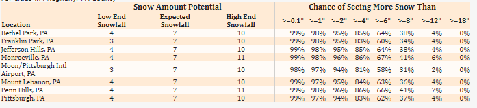
-
Western Pa / Pittsburgh area Winter Discussion ❄️☃️
Mailman replied to north pgh's topic in Upstate New York/Pennsylvania
18z NAM: -
Western Pa / Pittsburgh area Winter Discussion ❄️☃️
Mailman replied to north pgh's topic in Upstate New York/Pennsylvania
The best part is... it's ONLY December. -
Western Pa / Pittsburgh area Winter Discussion ❄️☃️
Mailman replied to north pgh's topic in Upstate New York/Pennsylvania
12z Euro: -
Western Pa / Pittsburgh area Winter Discussion ❄️☃️
Mailman replied to north pgh's topic in Upstate New York/Pennsylvania
Oh man. Euro has the heavy stuff over me at 36h. -
Western Pa / Pittsburgh area Winter Discussion ❄️☃️
Mailman replied to north pgh's topic in Upstate New York/Pennsylvania
I'm going with 7-9" IMBY. Interested to see what PBZ will have. -
Western Pa / Pittsburgh area Winter Discussion ❄️☃️
Mailman replied to north pgh's topic in Upstate New York/Pennsylvania
Totals are up from 6z on the 12z GFS. Gotta figure PBZ will bump things up a bit. -
Western Pa / Pittsburgh area Winter Discussion ❄️☃️
Mailman replied to north pgh's topic in Upstate New York/Pennsylvania
12z RGEM: -
Western Pa / Pittsburgh area Winter Discussion ❄️☃️
Mailman replied to north pgh's topic in Upstate New York/Pennsylvania
12z HRRR:
