Mailman
-
Posts
1,650 -
Joined
-
Last visited
Content Type
Profiles
Blogs
Forums
American Weather
Media Demo
Store
Gallery
Everything posted by Mailman
-

Pittsburgh/Western PA WINTER ‘25/‘26
Mailman replied to Burghblizz's topic in Upstate New York/Pennsylvania
NAM seems to have lessened the warm tongue. Some good news to start my day. -
Pittsburgh/Western PA WINTER ‘25/‘26
Mailman replied to Burghblizz's topic in Upstate New York/Pennsylvania
No mix on the GFS. -
Pittsburgh/Western PA WINTER ‘25/‘26
Mailman replied to Burghblizz's topic in Upstate New York/Pennsylvania
Good ol' DT. -
Pittsburgh/Western PA WINTER ‘25/‘26
Mailman replied to Burghblizz's topic in Upstate New York/Pennsylvania
Did not see this posted. -
Pittsburgh/Western PA WINTER ‘25/‘26
Mailman replied to Burghblizz's topic in Upstate New York/Pennsylvania
The northward trend has continued to some degree in the latest guidance suite. We still foresee northern Plains and southern Rockies mid-level shortwaves to phase as they cross into the Middle Ohio Valley. As they do so, a surface low develops near the Gulf coast and tracks northeastward. There is still some variance with the track of this low. The northern trend is starting to increase the chance of some mixed precipitation to the southeast of Pittsburgh, and a slight chance of freezing rain has been introduced to the gridded forecast. The chances of this are not high enough to meaningfully change the overall snow totals or the messaging to a significant degree, but it is a trend that we will need to monitor as the event approaches. In any event, support for overall lift remains quite good given a coupled 250mb jet structure, layered frontogenesis, and an inverted surface trough. A moisture surge including precipitable water totals of around 0.7 inch (90th percentile for late January) and a deep, saturated dendritic growth zone will also support significant snowfall totals. -
Pittsburgh/Western PA WINTER ‘25/‘26
Mailman replied to Burghblizz's topic in Upstate New York/Pennsylvania
-
Pittsburgh/Western PA WINTER ‘25/‘26
Mailman replied to Burghblizz's topic in Upstate New York/Pennsylvania
-
Pittsburgh/Western PA WINTER ‘25/‘26
Mailman replied to Burghblizz's topic in Upstate New York/Pennsylvania
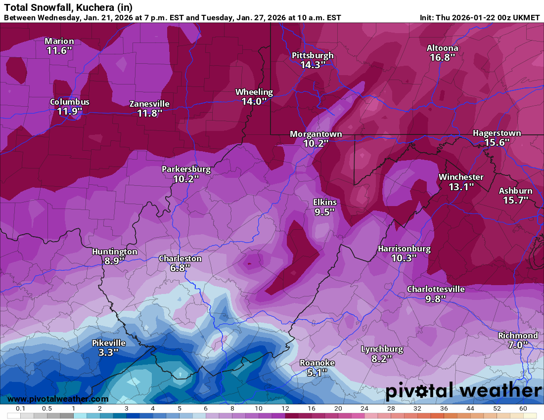
Even on the snowmaps, you can see the WTOD creeping a little bit north each run of the Euro. Hopefully it gets stuck in Morgantown.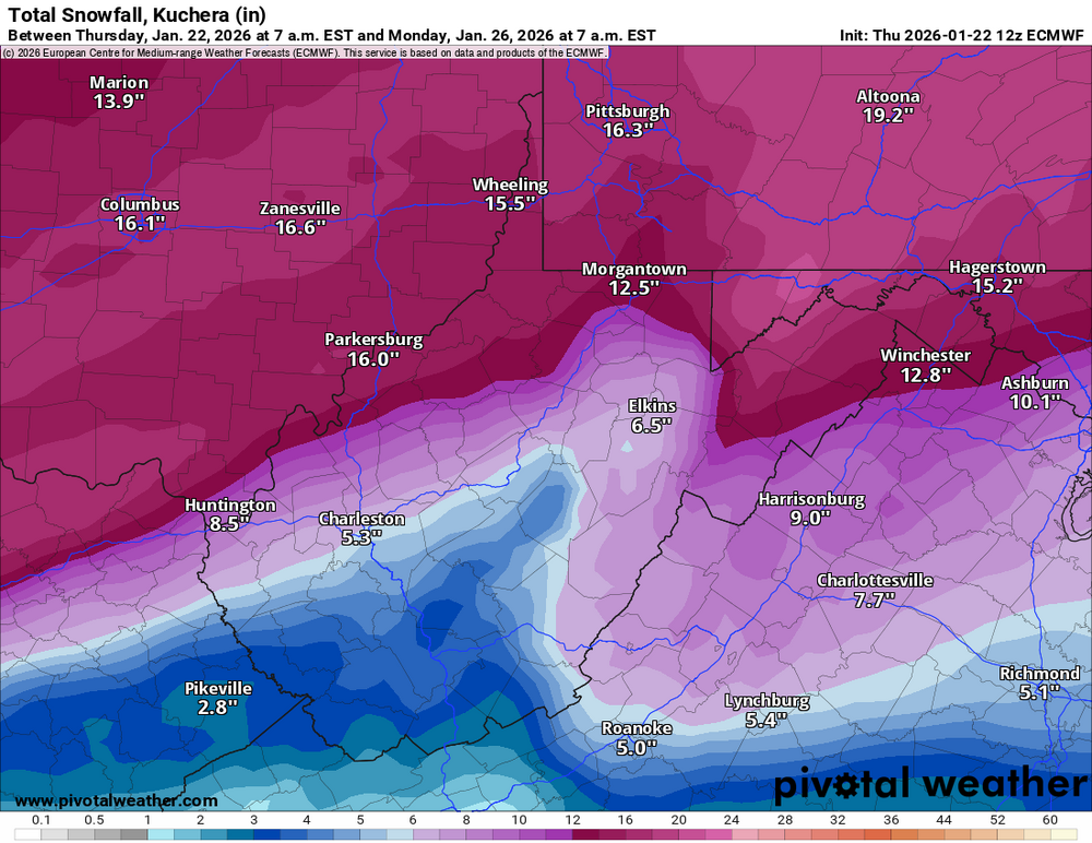
-
Pittsburgh/Western PA WINTER ‘25/‘26
Mailman replied to Burghblizz's topic in Upstate New York/Pennsylvania
That map tells me that PBZ must be REAL confident in the lack of a mix anywhere. I hope they're right. -
Pittsburgh/Western PA WINTER ‘25/‘26
Mailman replied to Burghblizz's topic in Upstate New York/Pennsylvania
Outlier. -
Pittsburgh/Western PA WINTER ‘25/‘26
Mailman replied to Burghblizz's topic in Upstate New York/Pennsylvania
Euro keeps the mixing in Fairmont. Niiiiiice. -
Pittsburgh/Western PA WINTER ‘25/‘26
Mailman replied to Burghblizz's topic in Upstate New York/Pennsylvania

-
Pittsburgh/Western PA WINTER ‘25/‘26
Mailman replied to Burghblizz's topic in Upstate New York/Pennsylvania
UK eventually mixes after you get 8-9". -
Pittsburgh/Western PA WINTER ‘25/‘26
Mailman replied to Burghblizz's topic in Upstate New York/Pennsylvania
-
Pittsburgh/Western PA WINTER ‘25/‘26
Mailman replied to Burghblizz's topic in Upstate New York/Pennsylvania
Mixing on CMC at 0z is not as pronounced as it was on 12z. Guess I'd call that an improvement. -
Pittsburgh/Western PA WINTER ‘25/‘26
Mailman replied to Burghblizz's topic in Upstate New York/Pennsylvania
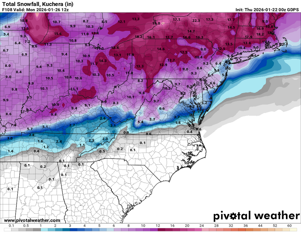
GFS looking ideal thru 93h. -
Pittsburgh/Western PA WINTER ‘25/‘26
Mailman replied to Burghblizz's topic in Upstate New York/Pennsylvania
Yep + QPF is up. -
Pittsburgh/Western PA WINTER ‘25/‘26
Mailman replied to Burghblizz's topic in Upstate New York/Pennsylvania
AIGFS seems to have delivered, also. -
Pittsburgh/Western PA WINTER ‘25/‘26
Mailman replied to Burghblizz's topic in Upstate New York/Pennsylvania
-
Pittsburgh/Western PA WINTER ‘25/‘26
Mailman replied to Burghblizz's topic in Upstate New York/Pennsylvania
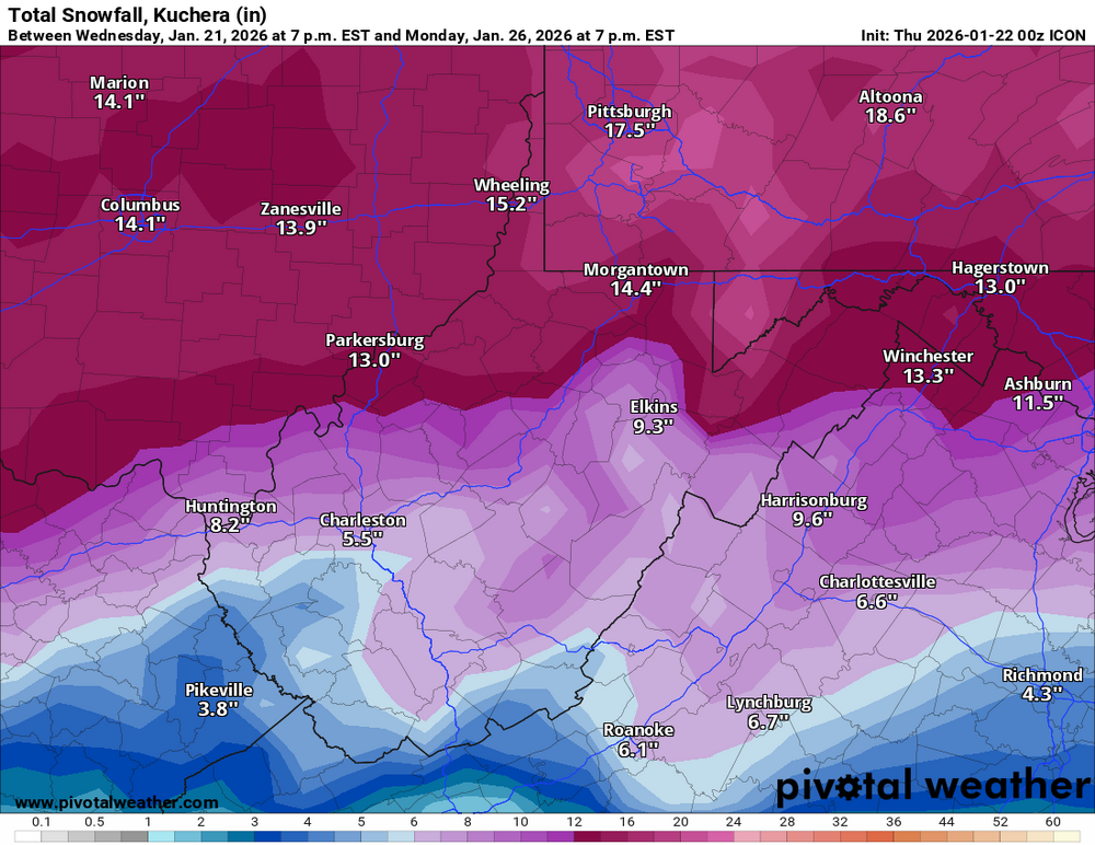
ICON is solid, if you're into that model. -
Pittsburgh/Western PA WINTER ‘25/‘26
Mailman replied to Burghblizz's topic in Upstate New York/Pennsylvania
Definitely a good sign when PBZ is discussing contingency plans. -
Pittsburgh/Western PA WINTER ‘25/‘26
Mailman replied to Burghblizz's topic in Upstate New York/Pennsylvania
Honestly, I'd have been more concerned if it showed primary going up 79. -
Pittsburgh/Western PA WINTER ‘25/‘26
Mailman replied to Burghblizz's topic in Upstate New York/Pennsylvania
KEY MESSAGE 2... Potential increasing for an impactful snow/winter storm Saturday night through Sunday night- The latest trends in both operational and model ensembles indicate a northward shift to impactful snow. A deepening trough is progged to track SE from the northern Plains, as a southern stream trough advances across the SW CONUS. These systems are expected to phase across the Central CONUS on Sunday. At the same time, a surface low is progged to develop across the Gulf Coast region, with an inverted surface trough northward to the Upper Ohio Valley region. Snow should begin to overspread the region Saturday night as these systems approach. A coupled upper jet structure should also enhance ascent Sunday, with frontogenesis as far north as I-80. Saturation throughout a deep dendritic growth zone should lead to efficient snowfall on Sunday as well. Ensemble based probabilities of at least a 6-8 inch snowfall have increased to 70-80 percent across much of the forecast area. Current probabilities of a 10 inch or greater snowfall have increased to 50 percent as far north as Pittsburgh, with higher probabilities to the south. Given the shift in some of the operational models, would like to see later data to initialize a potential Winter Storm Watch. Have held off on issuance for now in coordination with surrounding National Weather Service offices. Will enhance the Hazardous Weather Outlook to indicate the increasing probability of an impactful snowfall. The heaviest snow should begin to taper off overnight Sunday night, through cold NW flow and the crossing parent upper trough could result in lingering snow into Monday. With the track of the low to the south, the Upper Ohio Valley region will be in the cold sector so no potential for mixed precip is expected. This incoming system has the likelihood for widespread impacts from a significant snowfall. Stay up to date on later updates and possible watches. -
Pittsburgh/Western PA WINTER ‘25/‘26
Mailman replied to Burghblizz's topic in Upstate New York/Pennsylvania
I said last night that I will go in with the mindset that I'll take a 6" snowfall and anything more is a bonus. -
Pittsburgh/Western PA WINTER ‘25/‘26
Mailman replied to Burghblizz's topic in Upstate New York/Pennsylvania
Yep, because if it's modeled close to the border, it'll make its way up my way.