

cbmclean
-
Posts
2,590 -
Joined
-
Last visited
Content Type
Profiles
Blogs
Forums
American Weather
Media Demo
Store
Gallery
Posts posted by cbmclean
-
-
Was there some sort of kerfluffle with Eric Webber on Twitter?
-
3 minutes ago, TSSN+ said:
Alex I’ll take things you hardly ever see for 1000.

What do you mean? It snows in the NC sandhills while raining in Caribou Maine all the time.
-
 1
1
-
-
24 minutes ago, psuhoffman said:
@Terpeast you’re right that the pna ridge a bit too far west and associated WAR is a problem. But the answer isn’t “let’s lose everything else we also need for a snowstorm” like the NAO/AO and Aleutian low. There was more right than wrong with the longwave pattern. Blowing it all up seems unlikely to result in getting us closer to right. I’d prefer to root for the subtle changes we need in the pna and western Atlantic and not lose the good stuff.
ETA: the problem with “let’s reshuffle the deck” is there are lots of combinations and like 90% of them don’t work. It’s unlikely any reshuffle results in a better look when you had a decent longwave configuration and just needed a slight adjustment.
Just for the sake of discussion, since there isn't much else to discuss right now are there any reasonable breaks that we might conceivably get to improve the decent long-wave patter assuming it does reload. I mean other than reversing decades of excess heat dump into the oceans.
-
1 hour ago, CAPE said:
No real relax/reshuffle/warm up on the CMC ens. Just reload. More of the same general (Epic
 ) pattern. Go Canada!

I much prefer this since I am one of those weenies who hates winter warmth. But to my novice eye I see no 50/50 and the PNA ridge too far west. So as far as frozen, we are likely in the same fail boat. Am I catching on?
-
 5
5
-
-
5 minutes ago, DE2PA said:
At this point, we could get dropped into a barrel of tits and come up sucking our thumb.
That is pure magic. Snow breaking out over Lake Pontchartrain while it rains north of the Canadian border with Vermont.
-
1
-
-
8 minutes ago, psuhoffman said:
Since when do we need cross poler Siberian air to get snow?
Since a few years ago apparently. And it seems likely to remain that way going forward does it not? So now we either hunt perfection, or else leave the hobby.
-
12 minutes ago, psuhoffman said:
Yea but my point was why are mid latitude ridges becoming so strong that the last several times we had a -NAO we had this issue with a mid lat ridge pumping all the way north far enough to link with the block.
I think we know the answer to that question...
-
1 minute ago, Terpeast said:
The fact that WPC favors the Euro over GFS over the first 3 days of the model runs gives me pause. What if the Euro is correct on handling the ULL in W Canada for the first 72 hours from now.
Then we lose.
-
4 minutes ago, Solution Man said:
Ouch
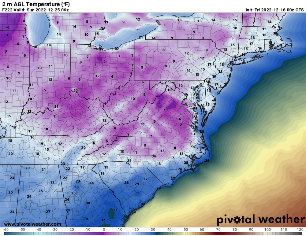
Crazy how much impact a fresh snow pack makes. RDU colder than Boston. Of course if the snow pack isn't there then you don't get anywhere near this.
-
9 minutes ago, SnowenOutThere said:
You could make a thread
I didn't know that I was authorized to do that. I thought only certain people could.
-
Just now, Weather Will said:
For what it is worth 0Z ICON is nothing more than a frontal passage.
I've never trusted the Germans since they bombed Pearl Harbor.
-
1
-
13
-
-
OK, I'll bite. Anyone willing to share their personal top 5 list for MA snow experiences, in ranked order, along with a brief description of why? I suspect the usual list of candidates will be in some order, PD1/2, Jan 1996, Jan 2016, Dec 2009 etc.
For those who are really bored (or just love talking about it) a detailed explanation of your ranking criteria would be welcome. Factors that I would personally consider are if I was doing it are
1. Amount of snow
2. Temps during event
3. How long did the snow stick around/temps after the event
4. How well was the event modelled (or not if you like surprises)
5. Bonus factors (high winds, high rates, thundersnow, number of Ji meltdowns etc).
-
Just now, cbmclean said:
It could use a 50/50 low.
-
20 minutes ago, clskinsfan said:
I will take my chances with something trying to cut into that block. I mean you simply cannot ask for a better setup for us to get plastered than this. It is pretty much text book perfection.

It could use a 50/50 low
-
16 minutes ago, CAPE said:
It seems we may get a RELOAD after a slight relaxation. No signs of a 'close the blinds' period.
")
Any signs of the "quit weather learn to macramé" signal noted yesterday with anomalous warmth even with a trough east/ridge west combo as mentioned by PSU?
I did note the kind of positive-ish EPO.
-
41 minutes ago, Amped said:
CMC is even better. It also likes the premature coastal idea for some reason. It's the only thing stopping a January 1966 setup.
January 1996 you mean?
-
23 minutes ago, beavis1729 said:
Yeah, and by a lot. Current record is 1064 mb on 12/24/1983.
I had thought that record was broken a few years ago in Mongolia.
-
20 minutes ago, stormtracker said:
Listen. I told you people nothing will happen until I return on Friday. Not only do I control this board, I control the weather. I got you for Christmas. Buckle up. As a bonus, I’ll one post Ji.
I did not realize your powers were so...powerful.
-
1 minute ago, Ralph Wiggum said:
But when it starts to moderate look out. People will likely take that as kicking the can if we do go cold/dry which in actuality it is not. It's a practice in patience. Those that have been here for a while know these are the risks we take. Get the cold in place....thats always phase 1. We will accomplish that portion it seems certain.
Phase 1: Establish Cold
Phase 2:...
Phase 3:... PROFIT...er I mean SNOW.
-
1
-
-
Responding to @H2O comment about running the A/C on Xmas (I have forgotten how to transfer responses between threads) Xmas 2015 was right at 80 °F in NC. And it wasn't just a one or two day thing either. I think there was a 10 day period where we didn't go below 60 °F. And it was quite humid as well. Not my favorite holiday memory. Overall December 2015 shattered the record for the warmest December on record. To give you even more idea, if December 2015 had been a November, it would have been well above average for Novembers.
New Years Day for this year had a high of 79 °C at RDU and was also quite humid. That warm spell wasn't as prolonged as Xmas 2015 but still a mood-killer. For some reason since 2015 the 10 or so days from the solstice to New Years have been mostly a horror show of torches, with the notable exception of 2017. But even then it was warm before Xmas. Xmas day was chilly and then the bottom fell out afterwards.
-
28 minutes ago, nj2va said:
Enjoy the high. Get ready for the low. Just read todays mood swings here as a preview.
I am well experienced. For some reason though I can't get off the roller coaster, even though I know intellectually that I should.
-
1 minute ago, cbmclean said:
My SE brethren are all excited about the 18Z GFZ. We never learn.
And that includes me.

-
My SE brethren are all excited about the 18Z GFZ. We never learn.
-
1
-
-
On 12/10/2022 at 3:45 PM, CAPE said:

Probably back here again


January 2023 Mid-Long Range Disco
in Mid Atlantic
Posted
What else is there to do? We wait and watch.