

cbmclean
-
Posts
2,591 -
Joined
-
Last visited
Content Type
Profiles
Blogs
Forums
American Weather
Media Demo
Store
Gallery
Posts posted by cbmclean
-
-
I'm driving up to Fredericksburg the 12th - 14th for business. I expect you guys to show some hospitality for a SE forum visitor with a little bit of the ole white powder.
-
Difference between GFS op and GEFS lately set me looking for some info about ensembles in gneral. Some interesting info here.
https://library.wmo.int/index.php?lvl=notice_display&id=12962#.Y4uYXnbMKUk
-
 4
4
-
-
47 minutes ago, Ralph Wiggum said:
Love the storm on the 12z gfs tracking from Lake Erie SE to Bermuda. Minor change from 6z
Isn't the Buffalo-to-Bermuda express a standard track? Its how Bermuda gets most of their blizzards.
-
 3
3
-
-
27 minutes ago, SnowGoose69 said:
This for whatever reason has been a consistent theme by the GFS the last week...its not unusual as we know to see big differences but its consistently been a torchy Op and cold ensemble on 90% plus of runs
Insert standard "Trust the warmest model" joke that's not really a joke.
Normally I would ignore long range op compared to ens, but maybe the higher resolution of the op is allowing it to "see" the super persistent PNA more accurately.
-
 1
1
-
-
13 minutes ago, Upstate Tiger said:
As mentioned above, the change from yesterday's forecast in the PNA is the difference. Yesterday's PNA forecast has it moving to positive between the 10-15th. Today it keeps it negative.

Which model(s)?
-
18 minutes ago, Ralph Wiggum said:
P05

I give that one the SE Visitor Seal of Approval(tm)
-
1
-
-
1 minute ago, H2O said:
I always debate changing mine but then I fear my posts would be completely ignored instead of the current 80% ignored
You changing your picture would be like my dad getting a nose ring; it would undermine the very foundations of my reality.
-
 1
1
-
4
-
-
3 hours ago, yoda said:
It's going to be that way for all the WC games from now on. Expect at least 5 minutes of added time to the end of games... it's what FIFA wants
I don't know anything about it one way or another, but I am curious why you believe that FIFA would want this? They think its more exciting?
-
24 minutes ago, psuhoffman said:
?
I think you had a debate AGAINST that guy that said the EPO/AO/NAO combo was physically impossible, so I think that is what CAPE is referring to.
-
1
-
-
56 minutes ago, WxUSAF said:
He’s referring to the MJO: https://www.cpc.ncep.noaa.gov/products/people/wd52qz/mjo/mjo_chi.shtml
200mb velocity potential is termed “chi” and “k=1” refers to wavenumber one.
Thanks as always.
-
7 minutes ago, Maestrobjwa said:

I mean yeah ya can't shovel pattern...but it's hard not to like having multiple shots of it to try and get something
Anyone have a translation for "k=1 CHI"?
-
35 minutes ago, Daniel Boone said:
For some odd reason he's not saying much . At least not on Twitter.
I'm not sure if that's encouraging or scary.
-
1
-
-
16 minutes ago, WxUSAF said:
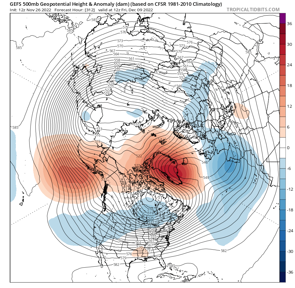
This is kinda nuts for a D13 ensemble mean for the -NAO. That Dec 6-11 period is an above-average early season snow threat window.
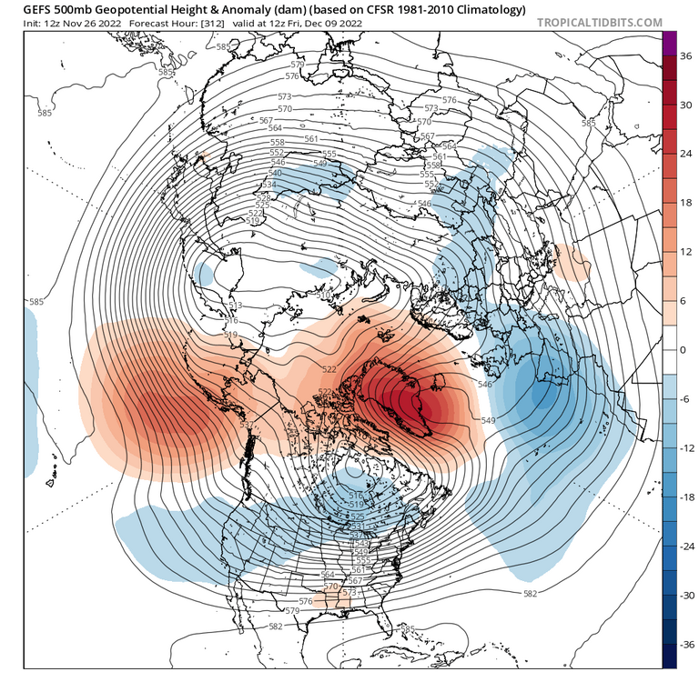
Asking as someone trying to make a significant effort to understand: isn't that a nasty -PNA signal though?
-
14 minutes ago, CAPE said:
The advertised looks on both the EPS and GEFS are acceptable at this range- the differences are probably related to the MJO wave progression, with the EPS moving it more quickly through phase 7 then dissipating it.
Someone recently made the claim that the EPS has a bias towards killing MJO waves. Is that a known thing?
-
2 weeks is ok, would rather not be 4. That takes us to right before Xmas.
-
The long range does not look awful at this time. That is all.
-
2 hours ago, midatlanticweather said:
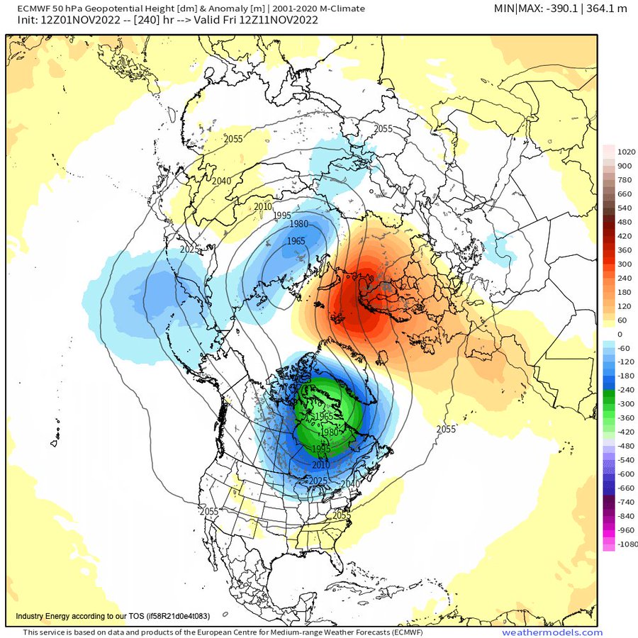
I lurk and learn. What info are we able to gather from 50 hPa? I'm familiar with the 10 hPa stratospheric charts, but not with 50 hPa.
-
40 minutes ago, midatlanticweather said:
Eric Webb was calling this guy out on Twitter today. Pointing out that this is showing the SPV instead of the TPV, so of much less interest,
-
2
-
-
Exactly 3.00 yesterday from Ian. Mostly light winds.
-
1 hour ago, NorthHillsWx said:
Ummm I don’t believe that. We maxed out at 93.6. There is not way RDU was almost 5 degrees hotter than here!
Just picked up 0.05” from a quick but heavy shower. This was our first rain in 10 days.
I just mentally deduct 4-5 degrees from their high on warm sunny days. The gave full-on UHI in effect.
-
1
-
-
2 hours ago, cptcatz said:
It's an interesting conversation. Your question of why would models be any good a predicting medium to long range cyclogenesis with accuracy could be answered with "why shouldn't they?" These models are run on some of the largest supercomputers in the world using so many data points from satelites, balloons, airplanes, bouys, etc., and they still can't figure out what's happening in only a few days?
Yes. And it took decades of patient effort and billions of dollars/euros to get that good. Predicting weather is just inherently difficult.
-
Picked up 0.64" yesterday afternoon in a nice downpour after just missing the morning stuff. Then got 1.81" overnight for an excellent 2.45" total in less than 24 hours. 4.31" for the month.
-
Maybe the SAL will block so much sunlight that it will cause massive cooling along the eastern CONUS.
-
0.41" today. Disappointed in this weekend. Was hoping to get a good soaking. Total of 5.25" for the month. Not too bad compared to May and June.
December 2022 Medium-Long Range Disco
in Mid Atlantic
Posted
If Chuck says a +PNA might be coming, I'm ready to listen.