

jm1220
-
Posts
26,187 -
Joined
-
Last visited
Content Type
Profiles
Blogs
Forums
American Weather
Media Demo
Store
Gallery
Everything posted by jm1220
-
Precip delayed=more time for warm air to take over before snow starts. We also want the snow to come in early before the warm air aloft has a chance to take over.
-
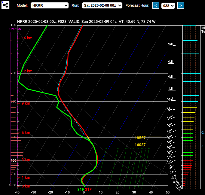
This is at 4z at around JFK. The 750mb warm layer is starting to show up here and maybe it's a little too cool at that layer or heavy rates that are happening here are holding the warm air back. The NAM has it warmer at that layer with a more pronounced warm nose. I tend to believe the NAM more but we'll see what the other 0z models show. https://www.pivotalweather.com/model.php?m=hrrr&p=ref1km_ptype&rh=2025020800&fh=21&r=us_ne&dpdt=&mc=
-
FWIW, 0z HRRR looks impressive for I-80/NYC/LI with a big thump especially for the N Shore. It eventually warms up around NYC at 750-800mb around 5z but by then most of it is over. It has the "come in like a wall" scenario. Not sure if it's underdoing the warm layer or the heavy rates are holding it back. Along I-195 seems to get a ton of sleet. Most of the storm for NYC is from 0z-6z, it's definitely racing along.
-
Also the mid level 850 low track. When that goes NW of you, S mid level winds are driving warm air in. With these kind of storms you hope a lot of overrunning precip can happen first before the warm air arrives. You want those to redevelop south of you to keep cold air in.
-
I’ll go 2-4”, 2” on the south shore/I-78, 4” along the north shore/I-80. 6” once you get north of White Plains/CT coast. For the southern NYC/LI areas hopefully some is left after it goes to rain. Inland it might just go to sleet. It’ll pad the snow totals for the season but I have pretty much zero excitement personally for a storm like this. Congrats inland and SNE. Seems pretty straightforward 6-8 locally 10” event for them up to Boston.
-
It’s the same rule as before, if snow comes in like a wall there’s a shot at the higher end accums. If shredded up the warm air will have an easier time advancing and changeover is sooner.
-
SWFE usually have low snow ratios because the warming air aloft often makes the snow making/max lift region in the cloud above the ideal temp for dendrites which form at -12 to -18C. So ratios are more like 10-1 or even less in some cases. Snow ratios are mostly determined by the cloud conditions where the snow forms. If the max lift is in the -12 to -18C region, ratios are maximized.
-
Maybe the Euro AI can save us all. This type of storm isn’t favorable for places along I-80 and south latitude. You get a diamond once in a blue moon like 2/22/08 but most are lousy disappointments while I-90 cleans up. If we can develop confluence or resistance over SE Canada it could be a game changer but otherwise this type of system tries to pump ridging ahead of it and come north especially when it’s a more consolidated system with more access to moisture.
-
There are multiple opportunities so we’re not holding all our hopes on one shot. The ensembles have been honking for days so it would be a huge face plant if it all fails.
-
Boston will probably do quite well. I'd say over 6". N shore might get 1" more than the S shore gets. I wouldn't go higher than 2-3" for the NYC area at this point. If we see more N bumps, more like 1-2". I-84 to I-90 is the best zone for this.
-
It's 0.25" freezing rain or higher, 6" in 12 hours or 8" in 24 hours. Sleet/snow are counted as the same.
-
I'm totally fine with no/limited backdoor fronts season.
-
I'm surprised, maybe hedging if the low chance the southern solution like NAM happens.
-
After the rain and temps now around 36, just some sloppy slush left. Winter of Fail rolls on!!
-
Since this is a more consolidated vort/stronger system overall than today, it will want to trend north unless something to the north like confluence can stop it which we don’t have. If we see more north shifts tonight I would call this one another fail for NYC/coast.
-
LOL we’ll see. ISP should have 17.3” by now, they have 4.8”. Maybe they got 0.5” today so that would be 5.3”. We have a shot on Sat PM but 3-5” would be a big win here so I’ll go 2-3” most likely before slop/rain (and not much of a N trend needed until it’s another maybe coating to an inch while SNE/Hudson Valley are the ones happy) that gets them to 7.8”. So they’d need something to deliver them a foot or more next week since this is our prime snow period and what they should have is going up fastest of the winter. Odds are strongly against that. I have 10” with that fell today and I should probably have 20” by now. LGA has done fairly well, maybe they have a shot.
-
I’d rather be north of here for this one. RGEM actually went north at 12z and there’s plenty of time for a N bump that tends to happen in SWFEs. The best place to be is probably I-84 corridor to I-90 unless we see a mass S migration on the models. I’d call 3-5” a pretty big win for I-80/NYC/LI. N suburbs likely 6”+.
-
Have about 0.5” on the table. Light sleet now. Temp 31-32. I expected this to be fairly lame and it was even lamer than expected. My side street is slushy, main road is wet.
-
There would’ve been more snow if the precip came in moderate to heavy to start, it would’ve held off the warming aloft better with more lift. There was also no good overrunning snow swath stretched east into the cold air. These are the rare SWFEs that are good for NYC. Instead we got the shredded up outcome, snow took forever to start and warm air aloft is able to easily overspread the area. Surface temp here is holding steady at 29-30 though so it may be hard to flip to plain rain away from the immediate coast.
-
It’s a SWFE, the vast majority of which suck for NYC and places I-80 and south. On Sat PM we get to roll the dice with another one, hopefully that one ends up better.
-
29 and light sleet. Basically a coating. Looks like it’s the maybe we make it to 1” outcome.
-
Yep, definitely still in the "hope for the best" stage. The ensembles are encouraging that at least we have threats but as usual it could all fall apart. We should get some snow tomorrow and more on Sat PM but beyond that is fragile depending on the development of one or several waves. North of us is the best place to be.
-
Some of the hi-res models look like absolute crap until you're well north into New England. Most of this subforum would struggle to get to 1" of whatever. Hopefully that's wrong and something like the HRRR is right. It'll be a nowcast situation.
-
22-24 in this area, NWS has my low at 26. I don’t see the onshore flow being strong enough to get us above 32 before the vast majority of precip is over. I think we get some snow but an inch of crud vs 2-3” depends on it coming in like a wall as the HRRR or shredded crap.
-
Low to mid 20s around here. I’m sure temps will spike when the flow strengthens off the water but good that we’re radiating well tonight. It won’t help the mid levels but may keep it frozen.


