hawkeye_wx
-
Posts
6,311 -
Joined
-
Last visited
Content Type
Profiles
Blogs
Forums
American Weather
Media Demo
Store
Gallery
Everything posted by hawkeye_wx
-

2024 Short/Medium Range Severe Weather Discussion
hawkeye_wx replied to Chicago Storm's topic in Lakes/Ohio Valley
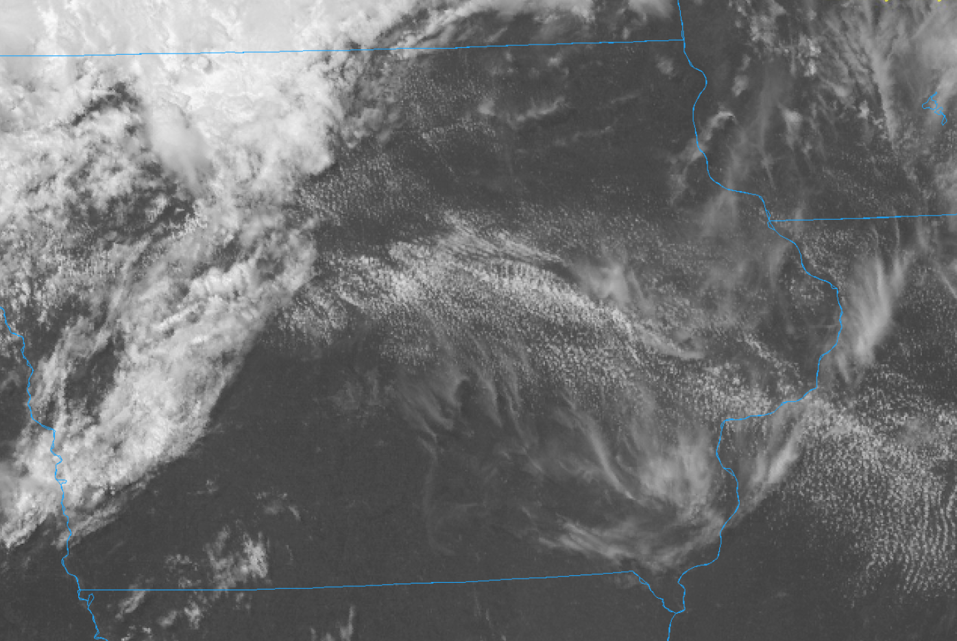
SUMMARY...A severe thunderstorm watch is likely later this afternoon for portions of Iowa into Northern Illinois and Southern Wisconsin in anticipation of convective initiation, forecast to occur between 19-21Z. Thunderstorms are expected to grow upscale quickly into a bowing line, which will be capable of 80+ MPH winds, though 1.00+ inch hail and embedded tornadoes are also possible. DISCUSSION...A subtle shortwave trough evident in both water vapor channel satellite imagery and RAP analyses is progressing eastward across southwest Minnesota. This shortwave is expected to provide additional ascent for convective initiation between 19-21Z over what is already a moist and unstable airmass, with widespread areas of MLCAPE > 3500 J/kg. This convective initiation is expected to occur anywhere from southern Minnesota, along the existing band of cloudiness, to central Iowa, where MLCINH has already eroded. Forecast profiles in north-central Iowa around the time of convective initiation show some slight curvature of the hodograph, resulting in modest 0-3km SRH of around 120 m^2/s^2. This will support the potential for tornadoes with any storms that remain isolated/discrete, but the overall expectation is for rapid upscale growth into a bowing MCS. The primary concern this evening is for damaging straight-line winds in excess of 80 MPH associated with this MCS, in addition to 1.00+ inch hail. Further east into Illinois, forecast hodographs show more favorable curvature and streamwise vorticity along and south of the surface boundary. Given the environment and expected storm mode, embedded QLCS tornadoes appear possible.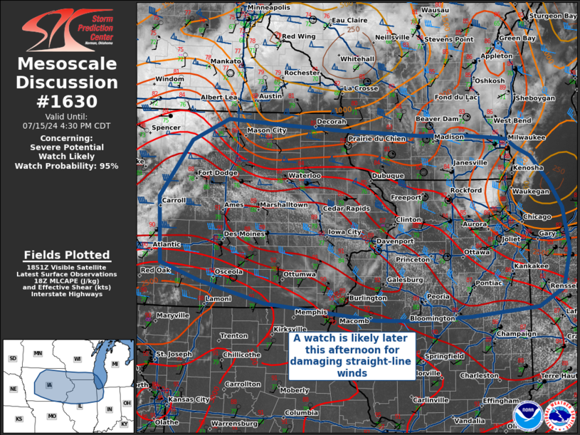
-
2024 Short/Medium Range Severe Weather Discussion
hawkeye_wx replied to Chicago Storm's topic in Lakes/Ohio Valley
The morning storms over southern Minnesota pushed a boundary down into Iowa. The boundary stalled wnw-ese through the Cedar Rapids area. 80º dews are piling up along the boundary this afternoon and there is a fair amount of agitation on satellite.
-
2024 Short/Medium Range Severe Weather Discussion
hawkeye_wx replied to Chicago Storm's topic in Lakes/Ohio Valley
For my area, it will depend on how soon the storms can fire. The latest HRRR doesn't show much firing until after it is east and south of Cedar Rapids. -
0.40" here overnight.
-
984 mb
-
Beryl's center actually moved east of north between the last two recon passes. The pressure, once again, has not changed.
-
There have been several center dropsondes through the afternoon and evening, but the one at 18:49z was 989.
-
The surface pressure is the same as it was six hours ago. The radar presentation continues to look pretty disheveled. As has been the case all day, a pocket of modest convection will pop up within the core, but as it rotates around, it dries up.... rinse, repeat.
-
The upper level outflow is beautiful. If Beryl had a tight and moist inner core, it would be cranking.
-
The process of mixing the dry air out of Beryl's inner core has been painfully slow.
-
The pressure has dropped to 989 mb. A more substantial drop will likely have to wait until tonight's dmax.
-
The moistness of the core has clearly increased through the day, but the convection is still weak near the center.
-
Per recon, 991 mb (12 kt wind)
-
This is one of those, "If it could have acquired its current level of organization yesterday morning...", situations. Fortunately, for the Texas coast, Beryl will run out of time before it can do anything crazy.
-
The newest recon pass is still finding only about a 1000 mb pressure. The work has started, but it'll still take the rest of the day and night to rebuild the core.
-
It's understandable why the GFS is showing only minor strengthening before Texas landfall. Beryl was gutted by the combination of land and shear. It will have to restart from scratch.
-
The 12z GFS has Beryl becoming so broad and disorganized that it is only able to get itself together at the very last minute.
-
Cancun radar Mexico radar
-
So Josh declined to fly to the Grenadines and missed a historic hit, but then he flew to Mexico for weakening junk?
-
Models are consistently showing that it will take about 36 hours over water for Beryl to reorganize. The environment should become more favorable as Beryl slows and turns north near the Texas coast.
-
Pressure is up to 972 mb, so it's weakening steadily tonight.
-
The pressure is up to 968 mb.
-
My first solid storm in several weeks dropped a quick 0.35" late this evening.
-
The GFS has shifted northward, has the storm creeping up the Texas coast.
-
The second recon pass found 965 mb with a dropsonde.