Met1985
-
Posts
16,672 -
Joined
-
Last visited
Content Type
Profiles
Blogs
Forums
American Weather
Media Demo
Store
Gallery
Everything posted by Met1985
-

2022-2023 Fall/Winter Mountains Thread
Met1985 replied to BlueRidgeFolklore's topic in Southeastern States
Yeah I think there has been some serious damage done to the model since this upgrade. It's behaving erratic and there is no continuity from run to run. To me it's the worst model we have currently. -
2022-2023 Fall/Winter Mountains Thread
Met1985 replied to BlueRidgeFolklore's topic in Southeastern States
This is like a broken record but again the GEFS does not agree with the OP. It blasts the front through here and the majority of us get cold.
-
2022-2023 Fall/Winter Mountains Thread
Met1985 replied to BlueRidgeFolklore's topic in Southeastern States
Euro and eps look good. Continued cold coming in with ensemble support. -
I've actually read that this new upgrade to the gfs has worse verification scores than the previous gfs version... I know this is a major shift in the hemispherical weather pattern but there has been very little continuity this week with the gfs....
-
2022-2023 Fall/Winter Mountains Thread
Met1985 replied to BlueRidgeFolklore's topic in Southeastern States
Once again the gfs own ensembles do not agree with the op. This is a running trend over several days... The GEFS blows the cold front through the region once again and looks much better than the OP. -
What sight do you use for the Canadian?
-
This is not the same gfs especially after the upgrade.
-
2022-2023 Fall/Winter Mountains Thread
Met1985 replied to BlueRidgeFolklore's topic in Southeastern States
Gfs says what plus pna and negative EPO. dumps some bone chilling cold all in the east and northern plains while we bask in the SER. -
2022-2023 Fall/Winter Mountains Thread
Met1985 replied to BlueRidgeFolklore's topic in Southeastern States
I doubt this happens this way but most get a few inches...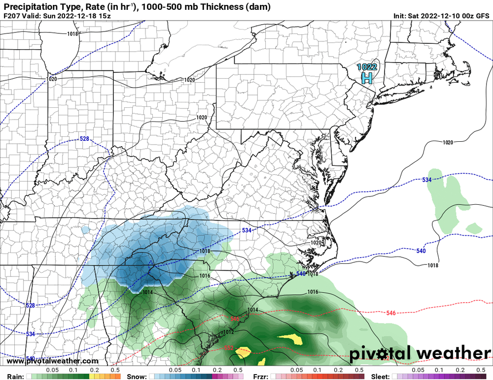
-
2022-2023 Fall/Winter Mountains Thread
Met1985 replied to BlueRidgeFolklore's topic in Southeastern States
Good Lord at the cold air coming down from Canada in the northern plains.
-
2022-2023 Fall/Winter Mountains Thread
Met1985 replied to BlueRidgeFolklore's topic in Southeastern States
00z op gfs looks a lot like the 18z. No real push in cold air. It's delayed a bit and just kind of bleeds through. I wouldn't even call it a cold front but a zonal flow. Again the ensembles have not been supporting this. If the Euro is right with blowing the front through then something is very wrong with the gfs. The freaking update broke it.... -
2022-2023 Fall/Winter Mountains Thread
Met1985 replied to BlueRidgeFolklore's topic in Southeastern States
Also a nice cool evening with a temp of 43 already with thick fog. I might be weird but I enjoy this weather at this time of the year. It's kept things cool and damp and something about the Christmas lights shinning through thick fog that looks like a landing strip for Santa lol. -
2022-2023 Fall/Winter Mountains Thread
Met1985 replied to BlueRidgeFolklore's topic in Southeastern States
The 18z ensembles still brings the cold front blasting through the area. Looks nothing like the OP. Looks good to me still. In general the GEFS has been pretty rock steady other than a few runs here and there... -
2022-2023 Fall/Winter Mountains Thread
Met1985 replied to BlueRidgeFolklore's topic in Southeastern States
No happy hour on the 18z. Actually probably one of the worst runs the past few days. The cold air just really slowly bleeds in but not a push like what has been showing. I expect more changes though as the verification scores for the op gfs have been meager recently... -
2022-2023 Fall/Winter Mountains Thread
Met1985 replied to BlueRidgeFolklore's topic in Southeastern States
Yeah no kidding! I mean any little change from the above mentioned will change the pattern but dang the euro and the eps is a thing of beauty. -
2022-2023 Fall/Winter Mountains Thread
Met1985 replied to BlueRidgeFolklore's topic in Southeastern States
Dang the 12z eps is a thing of beautiful! I mean we've not seen a look this good in years in my opinion. I mean this pattern change is on our doorstep. We are roughly 6 days away from this pattern change for us. Just an absolute beautiful run for us. Storm or no storm this is exciting times coming up. -
2022-2023 Fall/Winter Mountains Thread
Met1985 replied to BlueRidgeFolklore's topic in Southeastern States
The 12z euro is cold. Colder than the gfs. No storm next week but it brings down colder air further south which means days of upslope in my opinion. The euro stays cold through the end of the run with a huge high coming down from Canada also at the end. -
2022-2023 Fall/Winter Mountains Thread
Met1985 replied to BlueRidgeFolklore's topic in Southeastern States
All in all im happy with todays runs. Everything still looks good from the 15th on. I think in our region we are in the middle. The battle ground which im fine with. We get most of our best snows right on the line anyways. I see lots of threats for frozen precipitation on the 12z today. Euro is rolling out now. Also a nice chilly day today with the temp at 47 currently. -
2022-2023 Fall/Winter Mountains Thread
Met1985 replied to BlueRidgeFolklore's topic in Southeastern States
Yep I just wrote that. All inside 200 hours which is a big step. -
2022-2023 Fall/Winter Mountains Thread
Met1985 replied to BlueRidgeFolklore's topic in Southeastern States
More big improvements on the 00z gfs all inside 200 hours. This is the most aggressive and the deepest I've seen the gfs take this first batch of cold air across our area. Again the gfs is finally catching onto this major blocking. The upslope action would be a foot plus in favored areas on this run. -
2022-2023 Fall/Winter Mountains Thread
Met1985 replied to BlueRidgeFolklore's topic in Southeastern States
Yeah 1 inch of ice plus... I don't think so. Calling it right now. -
2022-2023 Fall/Winter Mountains Thread
Met1985 replied to BlueRidgeFolklore's topic in Southeastern States
Yeah it is. A wild solution but I think it has something to do with that cold high pressure that literally spins down from Canada into the NE. -
2022-2023 Fall/Winter Mountains Thread
Met1985 replied to BlueRidgeFolklore's topic in Southeastern States
00z gfs has a raging ice storm now for around the 15th.... Of course it does. -
2022-2023 Fall/Winter Mountains Thread
Met1985 replied to BlueRidgeFolklore's topic in Southeastern States
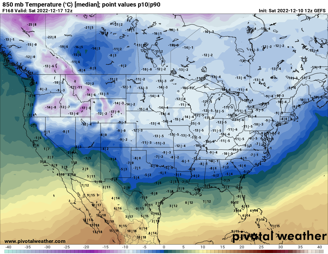
Also looking at the whole 18z GEFS that is some insane cold air up in Canada. I mean bone chilling cold air up in Canada and the mechanisms are there to bring chunks of that down into the lower 48. -
2022-2023 Fall/Winter Mountains Thread
Met1985 replied to BlueRidgeFolklore's topic in Southeastern States
Yeah this weather has been depressing at best but yes much needed rainfall for sure. Literally days and days of rainfall and clouds and fog. I enjoy this weather really but I'd rather see clouds and days and days of snow lol.