RogueWaves
-
Posts
2,559 -
Joined
-
Last visited
Content Type
Profiles
Blogs
Forums
American Weather
Media Demo
Store
Gallery
Everything posted by RogueWaves
-

Winter 2023-24 Longrange Discussion
RogueWaves replied to michsnowfreak's topic in Lakes/Ohio Valley
Measurable snowfall, or snow OTG?? Please say snowfall, lol. -
Nice look. Too bad it is not heavier. Still a nice break from the AZ summer treatment
-
Spring 2023 Medium/Long Range Discussion
RogueWaves replied to Chicago Storm's topic in Lakes/Ohio Valley
Which event are you calling the Super Clipper? Nvrmnd, Jan 22 right? Unfortunately I was not in Marshall then and missed it. One of the better storms over here even. -
holy shit! With all the dust continuing (mixing w/smoke) the scenes are like something out of a day after tomorrow film. Worst travel nightmare right there.
-
That used to mean WEED @Jackstraw would be reaching out
-
Another sh*t spring day but not a UP sh*t spring day. That's tomorrow
-
He's off wrt 5th in a row, but only 2017 jumps out as memorably AN in a dozen. So in a way that data set rather backs up his complaint. This may end up 2nd best but after SHSN all week and Freeze Warns in a row, it will be challenging to remember the great week of April.
-
The only upside to this cold spell is that it has stunted the rapid progress of spring at a nice period here in SEMI to extend bloom time which always passes too quickly.
-
I lived in the Northland then. Was the longest winter ever for me personally and greatest holiday snow depth (40") imby ever. With family up riding sleds at Christmas it was truly the stuff of white dreams. Now, without any of that in play, it would be an absolute nightmare, lol.
-
Bushes and smaller trees getting leafs already today, and we've really only had that one hot day at 77F. Kinda surprised tbh
-
Nickels or smaller - don't need my ride dented up
-
You remember Palm Sunday of '65? I thought that had an F4 up to E. Lansing area.
-
In S. Haven Sunday pm and noticed an entire front of a home had daffodils in full bloom. Was quite the sight. Meanwhile, not too far north: And the Yoop keeps getting deeper and deeper. There's always a gradient ofc this time of year, but seems exaggerated this year. Thinking severe season gonna be legit for a change.
-
Winter 2022/23 Short/Medium Range Discussion
RogueWaves replied to Chicago Storm's topic in Lakes/Ohio Valley
The two extremes here and just 2 years apart. Like Christmas '82 vs '83. Just weird how nature likes doing that around this corner of the globe. -
Winter 2022/23 Short/Medium Range Discussion
RogueWaves replied to Chicago Storm's topic in Lakes/Ohio Valley
Yeah. Miss north "not stank" -
Interesting. If you add 100 yrs to each, you get a group of some of the colder winters.
-
So the Nina has again delivered for SWMI but with even less staying power than 07-08. Wild how the lake has helped you hit such high totals over there. Across SMI west to east looks like AN->N->BN for seasonal snowfall.
-
Spring 2023 Medium/Long Range Discussion
RogueWaves replied to Chicago Storm's topic in Lakes/Ohio Valley
Remembering large piles of fresh white snow contrasted by dark green grass. A very Colorado looking scene on my HS campus in April '82. Large plow piles post green-up is a pretty rare combo for this region. -
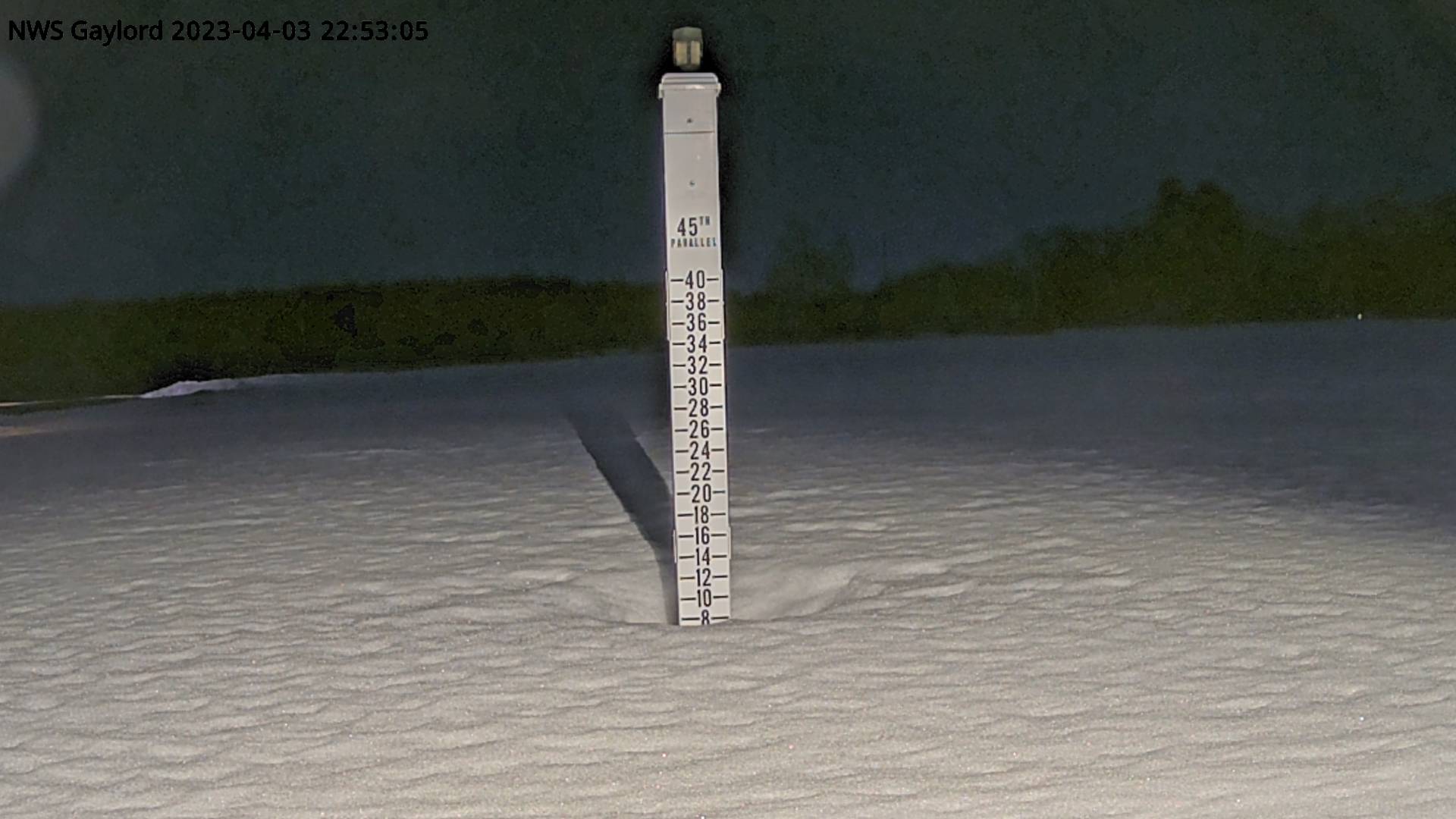
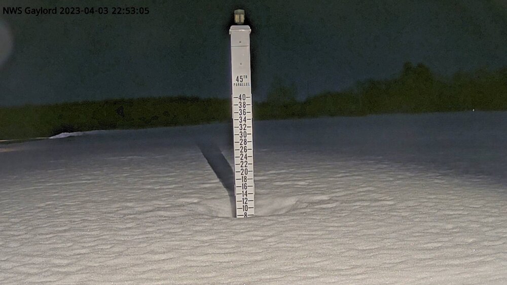
Great January day! (smh) First March afternoon high below freezing. First LES (0.2) since 1/27. Total up to 32.9" for here and that bumps my seasonal LES to an even 4.5" (15.6% of my total). I'm ok if we bust out some warmth tbh. Single digit WC's this time of year suck!
-
For those tracking: 000 NWUS53 KGRR 191116 LSRGRR PRELIMINARY LOCAL STORM REPORT NATIONAL WEATHER SERVICE GRAND RAPIDS MI 716 AM EDT SUN MAR 19 2023 ..TIME... ...EVENT... ...CITY LOCATION... ...LAT.LON... ..DATE... ....MAG.... ..COUNTY LOCATION..ST.. ...SOURCE.... ..REMARKS.. 0700 AM SNOW EAST GRAND RAPIDS 42.95N 85.61W 03/19/2023 M4.5 INCH KENT MI CO-OP OBSERVER APPROXIMATELY A 30 HOUR TOTAL. SNOW CONTAINED 0.23 INCHES WATER. SNOW SEASON TOTAL NOW 114.1 INCHES.
-
Winter 2022/23 Short/Medium Range Discussion
RogueWaves replied to Chicago Storm's topic in Lakes/Ohio Valley
I get all that and precision suffers ofc. APX finds a way to make it happen. Perhaps they should share their secret with the two SMI offices. I like maps, lol. In your opinion, how far off are they on avg? 6" in a season, or even more in certain regions? And you hint that it is almost always a lower amount of snow. I'd be more concerned if totals were artificially inflated. -
Winter 2022/23 Short/Medium Range Discussion
RogueWaves replied to Chicago Storm's topic in Lakes/Ohio Valley
Better than nothing imho. Unless you have another resource for better maps? -
The warm RN and 50's took half a month, but finally came along. Nuked "most" of the non-plow piles around here, but surprisingly, north facing slopes (M-14) and shaded places like wooded areas have a 2-3" cover hanging tough. That was some real-deal cement we got 3 headlines ago. Would take a storm like that any chance I could (sans the power outage ofc).
-
That'd be a double DAB for me, lol
-
"DAB" for me is <1/2". But tbh, @A-L-E-K just uses the term w/o a threshold.