RogueWaves
-
Posts
2,559 -
Joined
-
Last visited
Content Type
Profiles
Blogs
Forums
American Weather
Media Demo
Store
Gallery
Everything posted by RogueWaves
-
Jump in your time machine and get back to 1880 when things were really cookin'
-
My sister and her fam made one that included some sizeable boobs as well, lol. Back in the 90's iirc
-
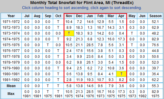
Wow, how horrible. I had almost 44" that season and thought it was "lame". As for the 70's. Where I was growing up it was much more consistently cold and snowy. Not to discount our recent string of great winters from roughly 02-03 until perhaps 15-16 (+/-). 97% (64 of 66) of months from when I was 7-18 yrs old with measurable snowfall! That was a very wintry run of 11 years where I grew up. Maybe you can dig-up an equal string of winters lately?
-
Arctic air on the move always makes for dynamic memorable outcomes. I was fortunate to be in the jackzone of both the PV bliz and this week's storm. Aside from similar tracks, this storm was pedestrian in comparison to 2014.
-
7.5" nice storm for Canton. Not quite the ARB jackzone, but close enough. Too bad the warmth of the soil has halved the depths around the Metro. Couple above freezing periods not helping either. But, we avoided more snowless brown going into the CAD spell.
-
Stepped out to 1/2" of mix in Canton. Better than a shutout.
-
h333 GFS has your next beefy jerky storm
-

Winter 2022/23 Short/Medium Range Discussion
RogueWaves replied to Chicago Storm's topic in Lakes/Ohio Valley
Had a couple decent squalls here, but again missed out on the better/wider bands. Going with 0.5" since midnight. Nice to see snow on snow even if small. Was hitting pretty good after work with car thermo at 29F (it reads a deg or two high I noticed). Cold snow for the first time in a month. Noticed snow blowing off the roof of the industrial building across the street at work. Didn't have anything like that last winter. If it happened, it wasn't on a work day. -
Whoa! Say it ain't so! For some reason I thought "Bill" was one of the younger Mets in that office. Sad day in our little Wx world
-
What's more rare for DTW and/or the N burbs, a true 12+ or a pair of 6's?
-
Midwest/Ohio Valley/Great Lakes Snow January 24-26
RogueWaves replied to Baum's topic in Lakes/Ohio Valley
Was that anything official, or just a random statement? -
Midwest/Ohio Valley/Great Lakes Snow January 24-26
RogueWaves replied to Baum's topic in Lakes/Ohio Valley
NOT a bliz, but bliz-like low vis for hours with thump snows at KDTW
-
Midwest/Ohio Valley/Great Lakes Snow January 24-26
RogueWaves replied to Baum's topic in Lakes/Ohio Valley
Main roads with salt had little impacts. Anything else was a rutted and packed ice adventure on my evening commute. Very awesome scene out there this evening with snow just caked on everything. Had about 5" of super dense compacted snow on the car in Livonia. Plows were working business lots like crazy and there was 8 or 10" between lanes here in Canton. This one's a winner despite the warmth of it. -
Midwest/Ohio Valley/Great Lakes Snow January 24-26
RogueWaves replied to Baum's topic in Lakes/Ohio Valley
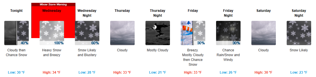
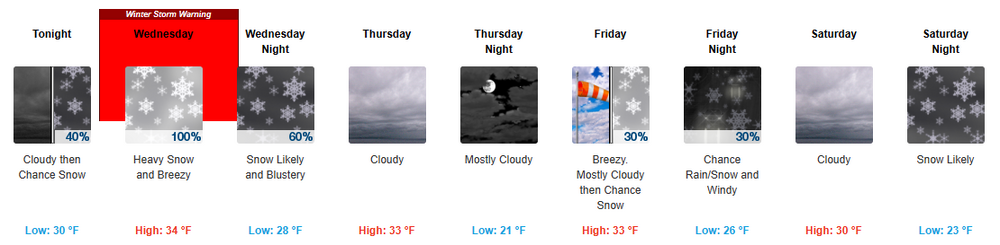
OFC. Ordered up by the secret magnet keeper himself DTX After careful deliberation, have opted to transition the Winter Storm Watch into the Winter Storm Warning for the 3 counties in far southeast Michigan. The highest accumulations seem most likely nearer the MI/IN/OH state line, but the trajectory of the system also puts downriver locations such as Wyandotte into a favorable zone for a slightly extended period of moderate to heavy snowfall. A Winter Weather Advisory will be issued on north into the I-69 corridor angling northeast into the Thumb where some lake enhancement will also come into play late in the day Wednesday. -
Midwest/Ohio Valley/Great Lakes Snow January 24-26
RogueWaves replied to Baum's topic in Lakes/Ohio Valley
Just glad to see BELOW freezing temps going into start time, especially after today's mini-torch and all the slop storms last winter. -
Midwest/Ohio Valley/Great Lakes Snow January 24-26
RogueWaves replied to Baum's topic in Lakes/Ohio Valley
Big Dogs don't hunt here in January anymore. Feb's got the ingredients lining up tho -
Stebo, is that you??
-
Midwest/Ohio Valley/Great Lakes Snow January 24-26
RogueWaves replied to Baum's topic in Lakes/Ohio Valley
Guessing @Stebo not active here anymore?? -
Midwest/Ohio Valley/Great Lakes Snow January 24-26
RogueWaves replied to Baum's topic in Lakes/Ohio Valley
Impressive by DTW standards. Flash-backs of the Bliz of '99 airport nightmare by NW Airlines. Hopefully no repeat. Encouraged my sister NOT to fly out tomorrow and she re-booked for Thur. Issued at 657 PM EST Tue Jan 24 2023 AVIATION... Early evening satellite imagery indicates a wedge of mostly clear sky over much of SE MI surrounded by MVFR clouds which are expected to fill in from the south and west during the night. MVFR then holds until snow spreads in from IN/OH toward sunrise when a quick progression down into IFR takes place. Some variation of intensity is expected during the morning while the leading edge moves south to north across the region. The peak snow intensity remains on track for the afternoon with LIFR/VLIFR in 1/2SM snow on average, and dips to 1/4SM in heavy snow also possible, for several hours as the low pressure system strengthens while moving through the Ohio valley. The low center moves over NW OH, Lake Erie, and southern Ontario by Wednesday evening resulting in a uniform east wind increasing and backing NW along the terminal corridor. Gusts near 25 knots add some blowing snow to the pattern as system snow diminishes mid Wednesday evening. For DTW... An area of MVFR clouds near the OH border move toward DTW mid to late evening and then hold with broken coverage until snow arrives toward sunrise. A 5 AM start time remains on track followed by a quick transition into IFR early in the morning. Some variation of intensity is possible during the mid to late morning before the peak snow rate occurs in the afternoon. Rate near 1 inch per hour in LIFR/VLIFR of 1/2SM to 1/4SM is likely for several hours before snow diminishes toward Wednesday evening. DTW THRESHOLD PROBABILITIES... * High for ceiling 5000 ft or less tonight through Wednesday. * High for snow late tonight through Wednesday. * Moderate to high for visibility of 1/2SM or less Wednesday afternoon. -
Midwest/Ohio Valley/Great Lakes Snow January 24-26
RogueWaves replied to Baum's topic in Lakes/Ohio Valley
This be the foundation snow. There are other dogs hunting in our future. -
Midwest/Ohio Valley/Great Lakes Snow January 24-26
RogueWaves replied to Baum's topic in Lakes/Ohio Valley
DTX trying to keep this one on the rails National Weather Service Detroit/Pontiac MI 947 PM EST Tue Jan 24 2023 .UPDATE... Evening observations are being monitored upstream for checks of onset timing on the SE MI snow event set to begin toward sunrise and then ramp up during the morning. The leading edge of precipitation associated with the textbook Gulf coast system is entering far southern IL/western KY at mid evening. This is about on schedule based on model comparisons which then project at least light snow ongoing by the 5AM to 7 AM Warning/Advisory start times from the Ohio border up to the northern Detroit suburbs. This initial phase of the event puts down just enough accumulation for hazardous travel during the morning travel peak in the Detroit metro area. Some wavering of coverage and intensity is then expected around mid morning as the leading isentropic ascent and moisture transport plays out against resident dry air over the south half of Lower Mi as indicated in the latest 00Z DTX sounding. A transition to a more dynamically forced phase of the event begins by late morning with a notable afternoon peak of coverage and intensity. The afternoon phase is driven by an excellent combination of coupled jet, short wave DCVA, and occlusion forcing that occurs along and north of a classic NW Ohio surface low track. A band of heavy snow is then expected around mid afternoon roughly centered on a line from Adrian to metro Detroit to Port Huron matching up with maximum elevated instability along the south flank of the TROWAL axis. Snow rate of 1 inch per hour is likely during this time with significant impacts to the evening peak travel period. Event total accumulation of 3 to 6 inches Advisory and 6 to 8 inches Warning are on target by the time snow diminishes Wednesday evening. && -
The Appetizer: Light Snow general 1-2 " event 1/22-1/23
RogueWaves replied to Baum's topic in Lakes/Ohio Valley
3X was a bit of a stretch (forgot to add Sunday's event) but not by much. With Sunday, I'm at 8.8" so "only" 2X in a place better known for T-storm wx. The ref to 04-05 was the Christmas storm that buried that area Louisville/Cincinnati. They must've been ahead of DTW early on regardless of the seasonal total. -
The Appetizer: Light Snow general 1-2 " event 1/22-1/23
RogueWaves replied to Baum's topic in Lakes/Ohio Valley
That's like 3X my total, which is totally unacceptable in my way of thinking. But prolly happened in 04-05 too -
DTW channeling MSP?
-
Midwest/Ohio Valley/Great Lakes Snow January 24-26
RogueWaves replied to Baum's topic in Lakes/Ohio Valley
But we've got the x-fer east also tugging against all traditional odds. 991 mb actually