RogueWaves
-
Posts
2,559 -
Joined
-
Last visited
Content Type
Profiles
Blogs
Forums
American Weather
Media Demo
Store
Gallery
Everything posted by RogueWaves
-

Historical Probability of a White Christmas
RogueWaves replied to michsnowfreak's topic in Lakes/Ohio Valley
For cities not listed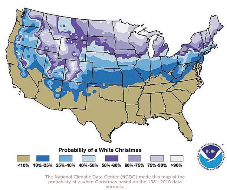
-
SWMI's version of that was 12-28, 2015. Looks like odds increase for those events during these Nino's
-
That almost sounds like 11-12 (which all seasonal outlooks were predicting "worst winter in history" due to prior 4 years of heavy winters). Obviously, the law of averages was against a 5th such winter. As said about 15-16, while it was a pretty mild winter, some of us cashed-in nicely like mby at 116% of average. December was the only truly bad month, but even it featured that strong sleet storm late in the month.
-
I'd say 0.3-0.4" here in Canton for the day. Expected only mood flakes, so over-performed.
-
The part about CLE was no joke! I once read old newspaper archives about snowstorms and one article mentioned a strong bomb-storm in 1873 that took a KIND->KAZO track.
-
Winter 2023/24 Short Range Discussion
RogueWaves replied to Chicago Storm's topic in Lakes/Ohio Valley
It reflects the same dying eastern flank/band that falls apart as it heads south over SEMI like with the Halloween system. Like nature said "let's cue-up a near carbon copy event". Perhaps I'll score the same 2/10ths -
NYE and ongoing across the lower lakes.. Phantasy storms can happen. Can't they?
-
..enters March '93
-
Not sure if you were in Genesee Cnty your entire life? If so, you may remember the April '75 storm? That was the biggest storm of my youth (10 at the time) for me personally. Similar to the Dec 2000 bliz, it dumped big fatties for hours then finished with a few hours of bliz conditions and near-zero visibility. At least in eastern Genesee where I was. 18" show-stopper. Too bad it was already spring break so I didn't get any snow days off from school . For Genesee Cnty, I think the only bigger storm would be the Jan '67 bliz with it's nearly 23" total.
-
Models stunk even with last Christmas's bomb storm, and that wasn't the mega-merger scenario of '78. First Chicago and SWI were supposed to get rocked by a crippling bliz, then after that went poof, they kept insisting Detroit would get 10" which in reality ended up closer to 4.
-
Winds were awesome, even further east on the "inflow" side. That was one of only 2 storms in my life that delivered snow well east thanks to timely occlusion. In SEMI where I was we went from strong East winds and ripping snow (briefly) to T-storms, back to 4" of heavy wet snow before it was over. Dec 09 bliz was the other one when I lived in SWMI.
-
Detroit wx summed-up in a sentence. Thx DTX.
-
..and here we go again with the phase-tease. Will this be the "3rd times the charm" storm? If so, I sure hope somehow it can get some cold air pulled in just a bit sooner. Prolly just a fluke run like b4 anyways, lol DTX Still, the exact timing of the infusion of cold air andposition of the deformation axis remains uncertain as we sort outthe interaction of the 3 strong upper level waves/troughs(Missouri/northern Florida/Central Canada).
-
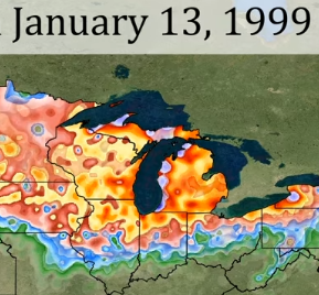
I was (no longer a kid) living in S. Bend and yeah, one of the all-time classic Midwestern flip-a-switch from mild to wild winter periods in history. Nevermind Chicago and mby with the big bliz. DTW sitting at 24" OTG by 1/13 is as mind-boggling as it gets.
-
Dec 2015 was a dry weenie roaster from the 1st thru the 17th, then we got 2" and 2 cold days followed by another dry roaster until the SLEET storm on the 28th which was a nice reward for all the suffering. Just shows things can sneak up even in a roast-fest of a December.
-
It's the dreaded CAD everyone's always harping about
-
Rumblings of a colder (MJO) and snowier (LR GFSh*t) look from around Christmas and thru the holidays. Less Grinchy anyways.
-
LOL, JB has AN temps across the entire northern tier. But I get it..
-
But it's a calm cold. My wife hails from Tomsk (over a bit from Omsk) and she's fine with a quiet -40C/F but can't stand the windy PV blasts we get here in the Midwest.
-
Winter 2023/24 Medium/Long Range Discussion
RogueWaves replied to Chicago Storm's topic in Lakes/Ohio Valley
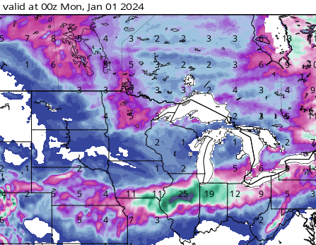
what? you don't like your 2 days of active wx per season?? Remember, last December we got this. Kinda figures we'd have to pay for it sooner than later.
-
Remember it well that morning. Thermo was pegged at ZERO with a 30-35 mph wind in your face. For early winter it was miserable in NWMI. And we didn't get the big totals they had called for to add insult to injury.
-
Jinxed, lol
-
fooled u
-
24.5" per NWS write-up with 12 foot drifts in the city proper. #wildstuff
-
2 for 2 on the models flashing the "big phase tease"