usedtobe
-
Posts
8,812 -
Joined
-
Last visited
Content Type
Profiles
Blogs
Forums
American Weather
Media Demo
Store
Gallery
Everything posted by usedtobe
-
at least they both have a thump, hope that is right
-
Look at the pivotal weather snow depth product, it usually provides a more realistic forecast with marginal temps.
-
I think the dewpoints tomorrow at 12Z are forecast to be in the upper teens west of the city and around 20 in the city so the cooling looks real especially if we get close to 09.25 " in 3 hours or so. That's a pretty good thump. Still, I'd only go with a coating to an inch aroudn the city and maybe 1 to 2 out west even though the models are showing the most precip south of us.
-
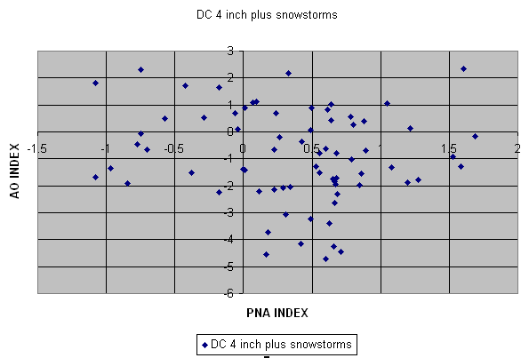
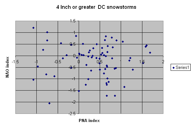
AO_vs_nao_snow.gif.jfifAO_vs_nao_snow.gif.jfifAO_vs_nao_snow.gif.jfifAO_vs_nao_snow.gif.jfifAO_vs_nao_snow.gif.jfifAO_vs_nao_snow.gif.jfif
-
And that's the big problem with the pattern, the ridge position and the location of the max positive anomaly within it. It's not favorable for moving the trough in the west. Of course, the ensemble mean still could be wrong way out there in fantasy land but if it is mostly right and we don't get a hit in the cold window earlier in the month, we probably are screwed through mid January.
-
Looks to me like there is one window around the 7th or 8th with the cold and then troughiness approaching the east coast. I'd call it partially ajar, far from a perfect pattern but one that could give us something with luck despite the ;latest GFS run taking it away. Still it's probably a long shot but at least its a shot. If that window closes, we may have to wait until the second half of January as the Pac ridge is too far west to supply anything but a negative anomaly in the west. The EPS does build the ridge into ak but towards the end of the run starts pulling it back again. That's so far outside of the skillful range who really cares. This pattern suck if you are a winter wx expert that focuses on DC. I looked for the AO/4 inch snowstorm graph hoping I had it on a thumb drive but it's not. I have it on my old PC so I'll look for it down the road. I need to get all my old excell files on the new PC.
-
Yep a positive AO/NAO and EPO, not a very inviting look for snow around DC.
-
Plus, the spaghetti plots are all over the place so there is probably no skill at that time range even for the ensemble mean. My guess is there will be more amplitude somewhere but where makes a huge difference and some ensemble members like the operational, others are much different from it.
-
Whitened the top pf the car and some leaves. Sounds like i was minned compared even to Prince Frederick
-
.67" in the gauge at 9:30. Last night at around 2:30 or so there was a velocity couplet in Clavert county but i don't see any reports of a possible tornado. I did lose power for about an hour.
-
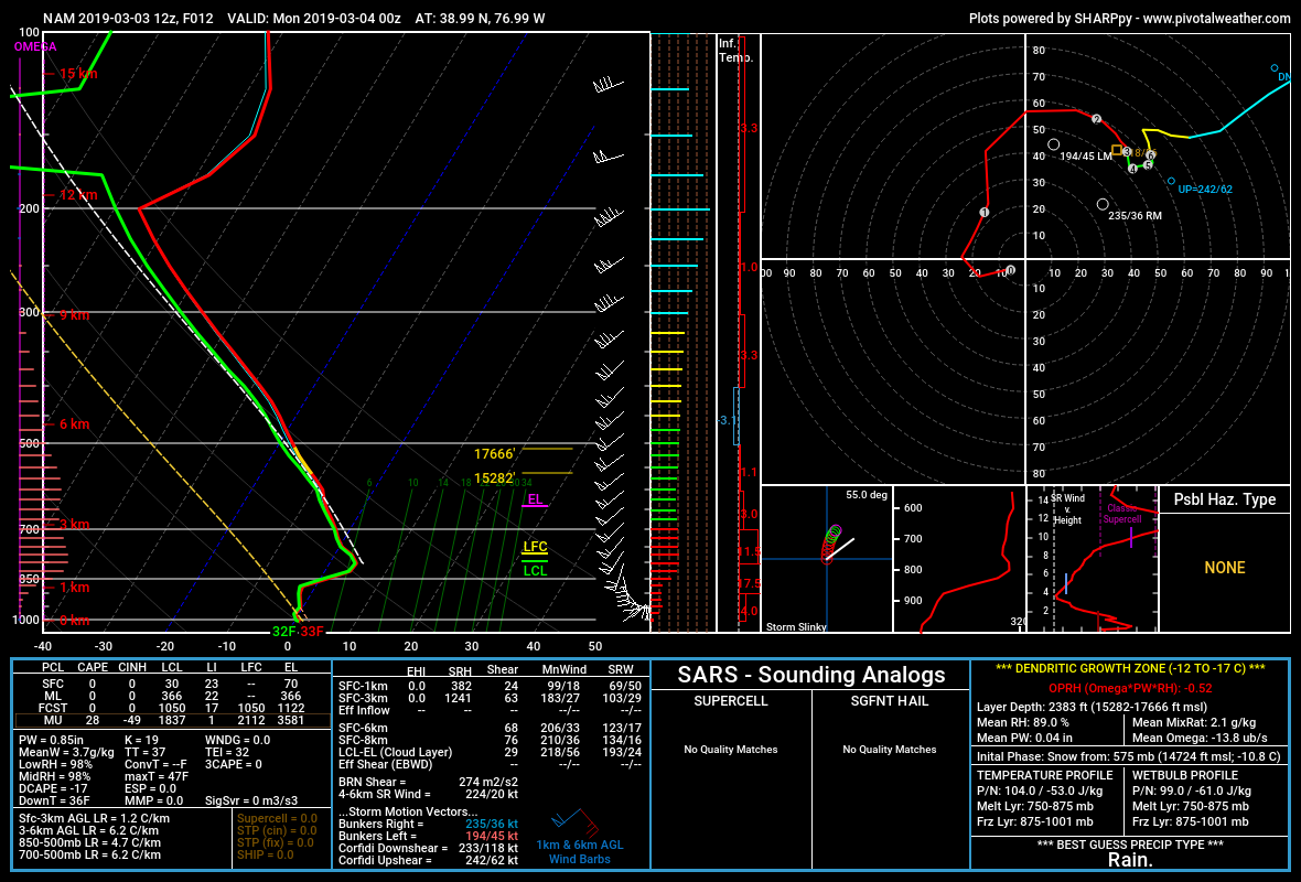
Here's the sounding from the NAM at DC at 00Z. Is it sleet or rain? it's right at that threshold and the sounding suggests folks just to the north and west will probably be getting sleet courtesy of PivotalWx.

-
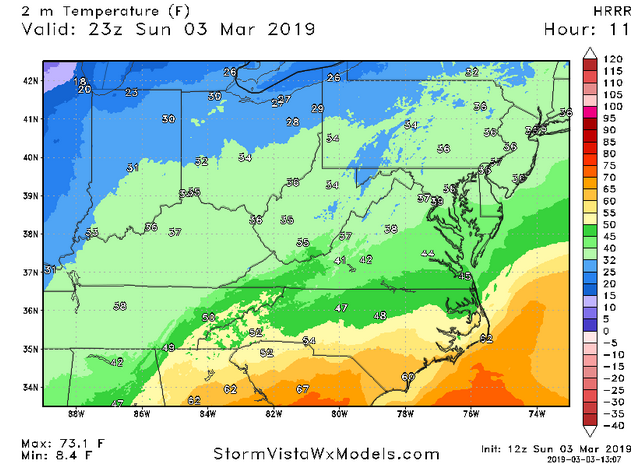
The 06Z Euro has the 2m temp at 34 at 00Z at DCA, The 11Z HRRR has it at 39. I've not been a big fan of the HRRR. My question to my friends at EMC, are there any verification of the HRRR 2m temps and is there a high bias? oops I showed teh 23Z but the 00Z has the same temp.
-
Not for you, probably go with 1-3 for you and 2-4 in Winchester. I'm certainly not impressed for DC.
-
If you want icing, hope the precip stays on the light side, otherwise the freezing on contact will reolease too much latent heat to get you the icing you crave,
-
Glad I'm not at Sterling. I'd hang with the 06Z Euro as it's the NAM but wow. The last two runs have been mega. We've been NAMed.
-
My ranking PDI Feb 5-6 2010 Dec 2009 1996 blizzard Feb 1958 March 1958
-
I remember having a long running thread on the pattern. I know i had one for the Feb storm but think I also had one prior to this one as the pattern was a great one with the superens D+8 really pitting out a number of good storm analogs. However, the models kept the low suppressed until around day 3 when the ens mean had a 500 pattern almost identical to the DC 8" or greater composite. Shortly after that I think Don Sutherland started comparing it to the knickerbocker storm. I tried finding the thread from eastern but could only find my thread on the feb 5/6 storm not the Deec one.
-
I thought i interesting that the CIPPS analogs identified 1983 as the top analog for the dec 2009 storm and the feb 6th 2010 one. The 2010 storm would have had the dec event as a top analogs but it was not yet int he data base.
-
This is probably already somewhere in the thread but I had saved it and early in the week looked at it. Fun memories from eastern http://www.easternuswx.com/bb/index.php?/topic/221595-widespread-20-inch-plus-amounts-verified/
-
Pretty much for us, I think new england can get a big one without it.
-

Weather References and Newbie Information
usedtobe replied to burgertime's topic in Southeastern States
Plus newbies need to know that the 850 temp is at around 5000 ft so the surface temps can often be above freezing when the 850 temps would indicate snow. Also, a warm layer during sleet events often develops above 850mb. -
But by 9:00 Am Feb 2nd the models were getting pretty adament except for a rogue run or two of the nam. On the second I wrote. "I talked to my friend Rich Grumm and he noted that the ensembles were showing an 90% chance of a foot of snow over my house" Ensemble systems often do not have enough spread but from that point on the ens system was emphatic about getting a major snowstorm. That's really rare.
-
I have some of the images from then though I think I've blown some of them away. It is fun reading the threads. I looked for the Dec 19th thread but couldn't find it. That was an exciting period when we all got along well because optimism and weenism ruled.
-
I think so but I wasn't as optimistic for dc for that storm since it was a miller b evolution. I don't think I saved that thread, only the dec and feb 5-6 ones.
-
Here's my eastern tread leading up to the storm. I doubt we'll ever see another stretch comparable to Jan 31 thru Feb 11 http://www.easternus...ounts-verified/