

usedtobe
-
Posts
8,812 -
Joined
-
Last visited
Content Type
Profiles
Blogs
Forums
American Weather
Media Demo
Store
Gallery
Everything posted by usedtobe
-
This is probably already somewhere in the thread but I had saved it and early in the week looked at it. Fun memories from eastern http://www.easternuswx.com/bb/index.php?/topic/221595-widespread-20-inch-plus-amounts-verified/
-
Pretty much for us, I think new england can get a big one without it.
-

Weather References and Newbie Information
usedtobe replied to burgertime's topic in Southeastern States
Plus newbies need to know that the 850 temp is at around 5000 ft so the surface temps can often be above freezing when the 850 temps would indicate snow. Also, a warm layer during sleet events often develops above 850mb. -
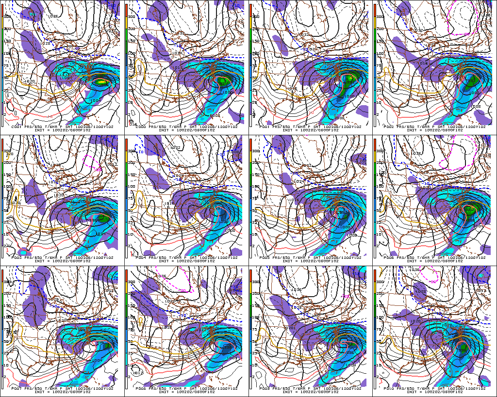
But by 9:00 Am Feb 2nd the models were getting pretty adament except for a rogue run or two of the nam. On the second I wrote. "I talked to my friend Rich Grumm and he noted that the ensembles were showing an 90% chance of a foot of snow over my house" Ensemble systems often do not have enough spread but from that point on the ens system was emphatic about getting a major snowstorm. That's really rare.
-
I have some of the images from then though I think I've blown some of them away. It is fun reading the threads. I looked for the Dec 19th thread but couldn't find it. That was an exciting period when we all got along well because optimism and weenism ruled.
-
I think so but I wasn't as optimistic for dc for that storm since it was a miller b evolution. I don't think I saved that thread, only the dec and feb 5-6 ones.
-
Here's my eastern tread leading up to the storm. I doubt we'll ever see another stretch comparable to Jan 31 thru Feb 11 http://www.easternus...ounts-verified/
-
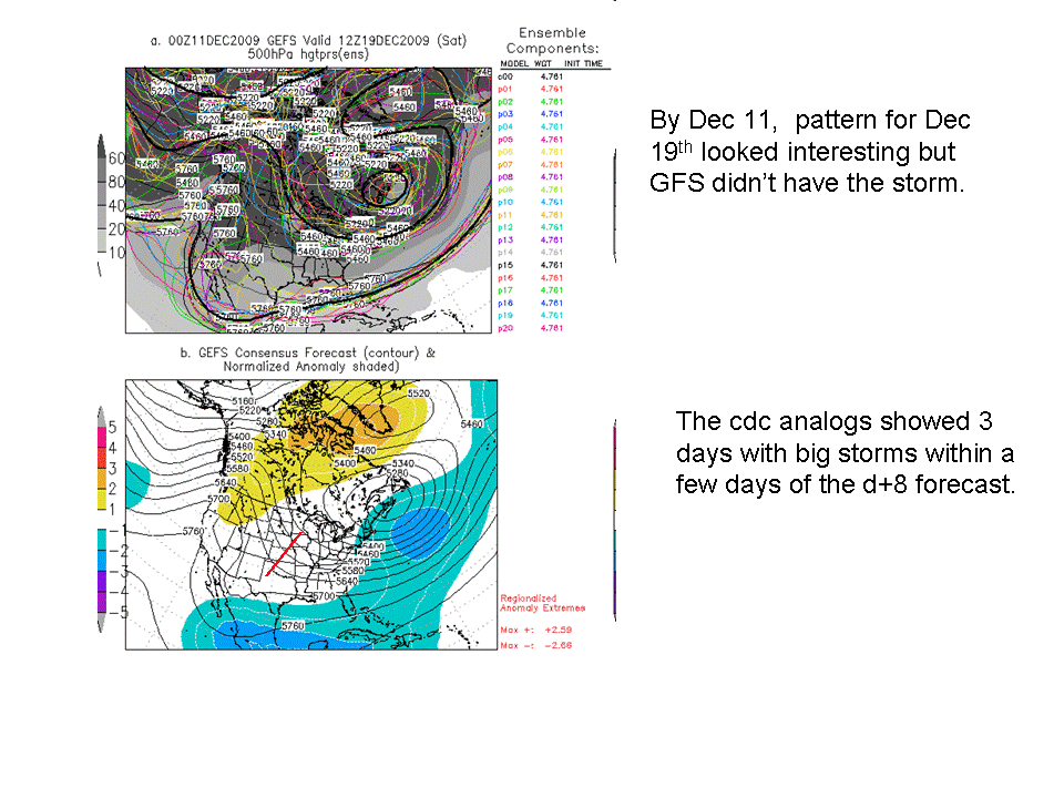
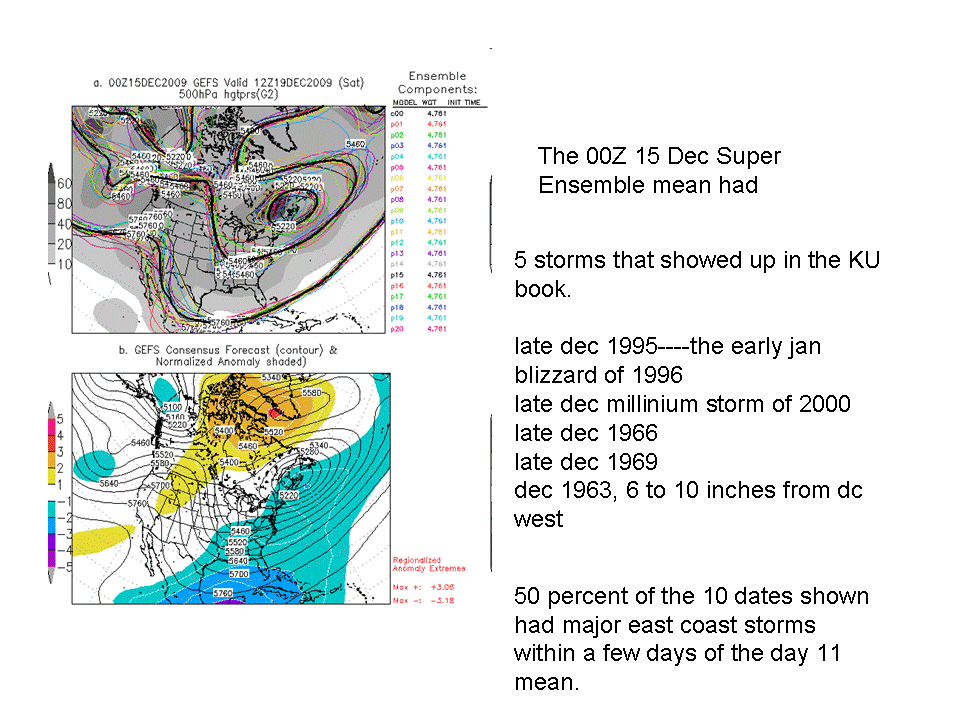
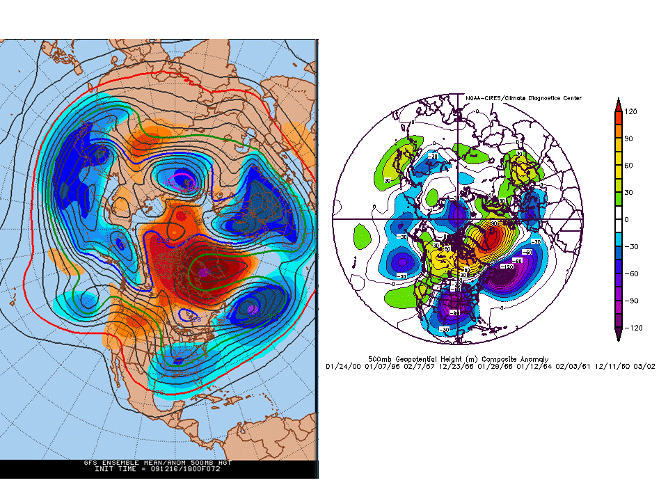
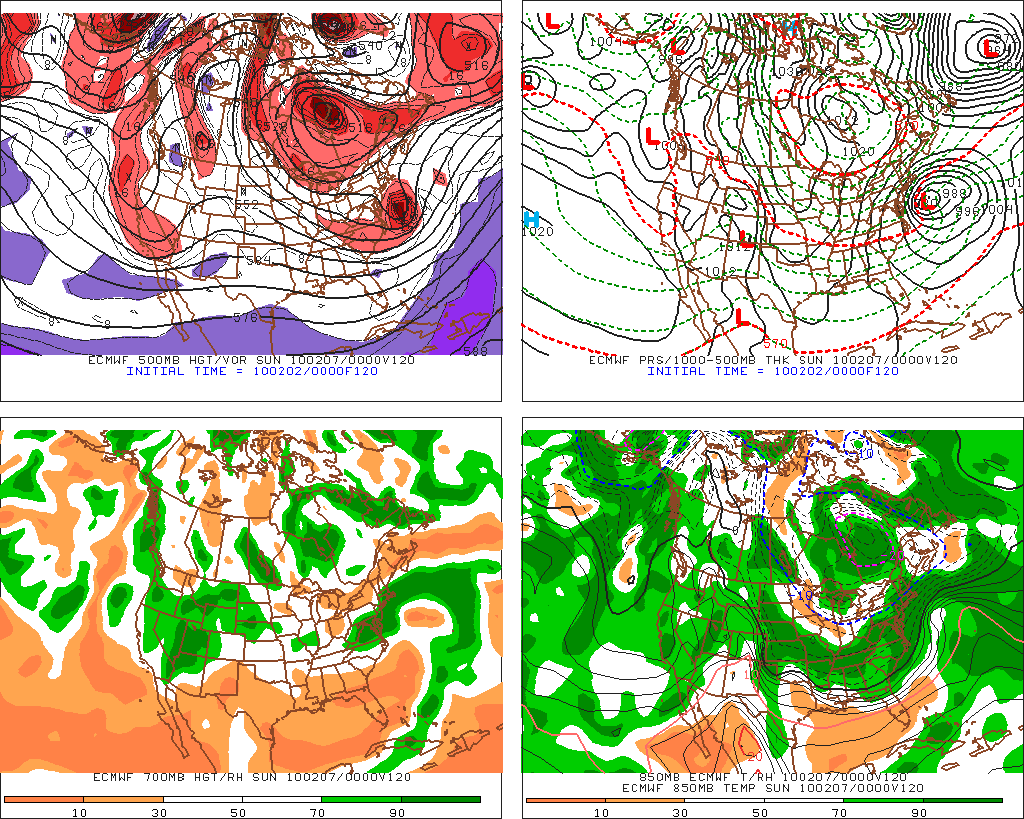
I remember really being stoked by pattern and talking quite awhile about the potential for a KU storm since the pattern was looking so favorable. By the 11th, The D+8 CPC analogs identified 3 KU storms within several days of the centered mean. By the 14 or 15 the number had jumped up to 5 inclduing some really famous events. By 72 the esnemble mean pattern was almost identical to KU storms that produced over 8 inches at DCA. It was actually a storm I was bullish about despite having a non-bullish rep.
-
Reconsider majoring in meteorology!
usedtobe replied to stormguy80's topic in Weather Forecasting and Discussion
Yes as would the ukmet guys as their model scores better than the GFS. Most offices I think have journeyman and interns so there is a place to learn forecasting. Plus, I think the training of the NWS is better on average than in the private sector. There are training modules and the Weather Event Simulator (http://www.wdtb.noaa.gov/tools/wes/index.htm) where they can work on canned forecast problems. -
Reconsider majoring in meteorology!
usedtobe replied to stormguy80's topic in Weather Forecasting and Discussion
Good for you, do you still live in Calvert County? -
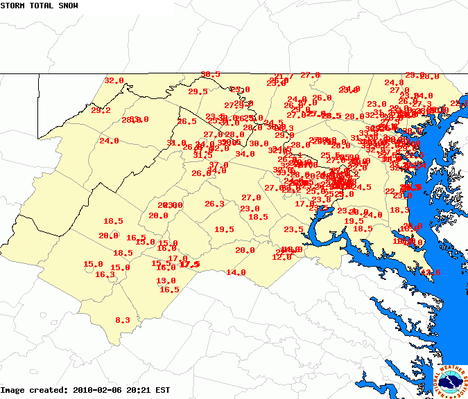
WVclimo saved this from the thread I had written about the event. It was fun rereading it. This will be a truly historic storm and has very good shot at breaking the dca snowstorm total for reagan national airport. Why am I so giddy. Well, I talked to another old time met and he was saying he thought the warm advection between HAT and DCA was the same as during the 1979 event which is the current reagan national record. Also, the 06Z nam and 06 gfs both have more than 2.75 inches over dc. Normally I might discount them, I suspect the nam's 3 inches is too high but do think that over 2.5" inches is likely. the storm with that type of moisture was the feb 2003 event except this one will be all snow over dc, that one mixed. Why am I so sure this will be snow, it's teh confluence, this one's confluence is much stronger than that one. That storm produced a large area of 20 plus inches of snow across the dc area into parts of delmarva, this one should too! That storm produced pockets of ovr 30 inches, this one probably will too. The one difference is this one will probably have the 20 inch plus amounts across PG county and at least the northern half of calvert. This is going to be a truly disruptive storm. I've filled one of my bathtubs with water and am putting lots of perishables in a cooler that I'm going to put in the snow so I don't have to open the freezing or fridge if we lose power. I think that's a possibility. Phl still looks to get heavy snow, JamieO is still in the tight gradient. Nothing has changed from last night except the models are even wetter.
-
I think those only go back to april. This site goes back anc catches both the Dec and Feb storms. http://charlie.wxcaster.com/cgi-bin/namModelArchive.cgi http://charlie.wxcaster.com/cgi-bin/GFSModelArchive.cgi I had already posted them once but no one reads through threads.
-
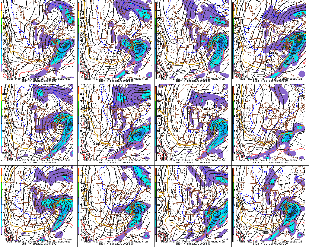
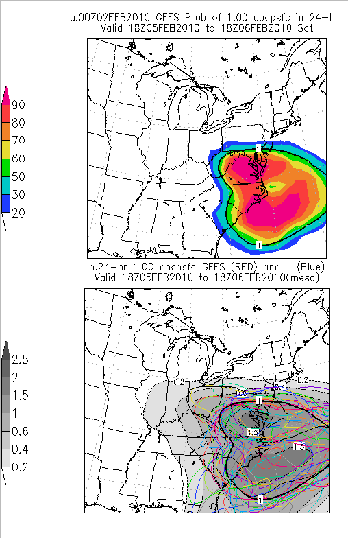
By 138 hours all but one GEFS member was forecasting a major storm. By 102 hours every member had a major snowstorm 90% of the GEFS ensemble members started showing double digit snows. BY 120 hrs the eruo had brought a 500 low just to our south and made it a big storm. By 72 hr the nam looked great and kept getting wetter each run. I have some of those maps but there are too many to show. I wish I had my thread from eastern on it as the day before it started as I changed the headline to read widespread 20 inch amounts likely. I sounded like JB. I got downright giddy. I also remember that the D+8 superensembles kept spitting out 5 6 inch or greater storms most being KU storms and at 48 hrs the CIPS analogs picked 1983 as its top one. It was one of the best forecast storms I can ever remember. Maybe the best. If you are real geeky. Her's a location where NAm forecasts are archived. You can look at its forecasts for the event. Basically pretty darn good. http://charlie.wxcaster.com/cgi-bin/namModelArchive.cgi you can also get the gfs http://charlie.wxcaster.com/cgi-bin/gfsModelArchive.cgi ]
-
I remember posting about it and Jason quoting me on the Capital Weather Gang site and my neighbor telling me that he had seen me quoted. I think I said something like we hadn't seen a storm like this one before in dec for the dc area. Beyond that, I remember being excited that my part of Calvert county stayed all snow.