

Gravity Wave
-
Posts
1,150 -
Joined
-
Last visited
Content Type
Profiles
Blogs
Forums
American Weather
Media Demo
Store
Gallery
Everything posted by Gravity Wave
-

September 2018 Discussions & Observations Thread
Gravity Wave replied to Rtd208's topic in New York City Metro
This is also going to help fill in that long evening model hole between the 18z GFS/RGEM at 4:30/5:00 and 00z NAM at 9:30/10:00 (I'm ignoring the 21z SREFs in that because LOL). -
September 2018 Discussions & Observations Thread
Gravity Wave replied to Rtd208's topic in New York City Metro
Really hope this is right.
-
September 2018 Discussions & Observations Thread
Gravity Wave replied to Rtd208's topic in New York City Metro
The line is starting to look better as it enters more unstable air. Lapse rates aren't ideal but most others indices look at least decent. -
September 2018 Discussions & Observations Thread
Gravity Wave replied to Rtd208's topic in New York City Metro
My favorite part of the summer was when the atmosphere spontaneously combusted with non-forecasted tropical thunderstorms. -
September 2018 Discussions & Observations Thread
Gravity Wave replied to Rtd208's topic in New York City Metro
There's always something missing in this region when it comes to big severe outbreaks, usually either shear or lapse rates. Most of the best storms I can remember, whether here or in Allentown, have come on days which weren't supposed to have significant outbreaks. The 3km NAM has some discrete cells popping front of the squall line Wednesday evening, but under its current timing the front would come through here during the early morning hours of Thursday, which could limit the severe potential. -
I nominate Hurricane Lili for "Most Overhyped."
-
Yeah. Call me no fun but I think that professional agencies should refrain from silly, inane stuff like that.
-
Major Hurricane Florence: STORM MODE THREAD
Gravity Wave replied to stormtracker's topic in Tropical Headquarters
Could Florence's SW drift combined with the NE flow of the Gulf Stream mitigate the impacts of upwelling in this scenario? -
September 2018 Discussions & Observations Thread
Gravity Wave replied to Rtd208's topic in New York City Metro
Still socked in with low clouds in Midtown, although the sky is getting lighter. I'm not going to complain if the sun stays away with these high dews. -
Hurricane Florence Catch all Thread
Gravity Wave replied to Brian5671's topic in New York City Metro
GFS caves completely. Is the Euro back to being the King? -
My reaction when I saw the GFS cave to the Euro:
-
September 2018 Discussions & Observations Thread
Gravity Wave replied to Rtd208's topic in New York City Metro
I can see NYC's snow drought had a serious psychological impact on those who experienced it. I never went through anything quite that bad but growing up in Allentown we got fringed by almost every major snowstorm of the 2000s (Jan 2005, Feb 2006, Feb 2007, December 2009, Feb 4-6 2010, with PDII being the one exception) before February 10, 2010 broke the curse with 18 inches of snow in 8 hours during my last winter there. Since then Allentown's had 3 18+ storms and I missed all of them, including 30" with the Blizzard of 2016 that hit 24 hours after I left to go back up to school. -
Hurricane Florence Catch all Thread
Gravity Wave replied to Brian5671's topic in New York City Metro
Yeah this threat is all but dead for our area unless the WAR suddenly gets weaker for next week, which seems unlikely. -
Hurricane Florence Catch all Thread
Gravity Wave replied to Brian5671's topic in New York City Metro
Definitely starting to feel better about my flight out of LGA Friday morning. UKIE and GGEM have it going into Savannah now LOL. -
September 2018 Discussions & Observations Thread
Gravity Wave replied to Rtd208's topic in New York City Metro
Hearing about heatwaves from way back then makes me wonder how anyone could bear living here without AC. -
Hurricane Florence Catch all Thread
Gravity Wave replied to Brian5671's topic in New York City Metro
Yeah, i think people are being a little cavalier in saying it won't be more than a 1 by the time it gets up to the Delmarva (assuming no significant land interaction over NC, of course). E: Another issue if it really hugs the coast and stalls is that upwelling impacts could be mitigated by the relative shallowness of the continental shelf. -
September 2018 Discussions & Observations Thread
Gravity Wave replied to Rtd208's topic in New York City Metro
Storms beginning to pop in NWNJ. -
Hurricane Florence Catch all Thread
Gravity Wave replied to Brian5671's topic in New York City Metro
Right now it's GGEM, Euro, and UKIE vs GFS, although the Euro brings an organized Florence up north after NC landfall while the GGEM has it stalling and dying out down there. -
Hurricane Florence Catch all Thread
Gravity Wave replied to Brian5671's topic in New York City Metro
Yikes.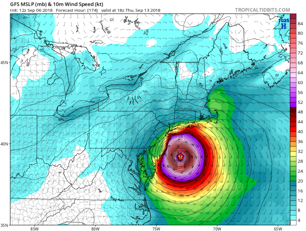
-
September 2018 Discussions & Observations Thread
Gravity Wave replied to Rtd208's topic in New York City Metro
Half the buildings in this city need to be torn down anyway, the dewsaster is a good excuse to speed things up. -
September 2018 Discussions & Observations Thread
Gravity Wave replied to Rtd208's topic in New York City Metro
Except Atlanta actually has air conditioning in more than 20% of the buildings. -
September 2018 Discussions & Observations Thread
Gravity Wave replied to Rtd208's topic in New York City Metro
Really? I've always seen NY, NJ, PA, DE and MD as the Mid-Atlantic with VA, WV and NC thrown in as well depending on the source. -
September 2018 Discussions & Observations Thread
Gravity Wave replied to Rtd208's topic in New York City Metro
You can really tell which locations got helped out by the abnormally warm SSTs. -
September 2018 Discussions & Observations Thread
Gravity Wave replied to Rtd208's topic in New York City Metro
On the plus side GFS says this weekend is gorgeous and next week looks like low-mid 80s with low dews, which will probably seem refreshing after this hell. -
September 2018 Discussions & Observations Thread
Gravity Wave replied to Rtd208's topic in New York City Metro
A little tropical excitement would somewhat make up for the general awfulness of the weather this summer and hopefully change the pattern in time for fall.


