Gravity Wave
-
Posts
1,152 -
Joined
-
Last visited
Content Type
Profiles
Blogs
Forums
American Weather
Media Demo
Store
Gallery
Everything posted by Gravity Wave
-
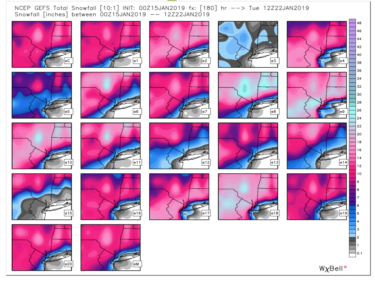
GEFS look really good too. Lots of members with big hits down to the coast.

-
Good news, let's see if the Euro follows.
-

January 2019 General Discussion & Observations
Gravity Wave replied to Rtd208's topic in New York City Metro
Impressive signal on the GEFS for a system in the 24-26 timeframe. -
Yeah I know, tidbits is so slow with the FV3 though.
-
FV3 has lost the cutter idea, looks a lot like the GFS.
-
The second low is an interesting twist, and likely a positive one for us. Interested to see how this continues to evolve over the next several days.
-
Euro honestly wasn't that far off. The key players for this system won't be onshore until Thursday so there's plenty of time for a positive trend.
-
Not exactly, but a week or so ago i think I remember reading that it would be within a few weeks...
-
When the old GFS gets taken offline soon we're honestly going to be down to 2 semi-reliable models (Euro and UKMET). GEPS seem better but IDK if they're any better than the GEFS.
-
Am I the only one who thinks the FV3 might actually be worse than the GFS?
-
So nice to have a threat to track. The last 8 weeks have been painfully boring.
-
January 2019 General Discussion & Observations
Gravity Wave replied to Rtd208's topic in New York City Metro
It would be fun to see the city drop below zero but no one should be rooting for what the models are showing after the storms. I experienced -20 in Ithaca in February 2014 (no wind, fortunately) and it was insanely cold. If you didn't wear goggles your eyes would instantly water from the cold and start to freeze shut. -
January 2019 General Discussion & Observations
Gravity Wave replied to Rtd208's topic in New York City Metro
Euro digging more with the SLP this run. Upper levels look fantastic. -
January 2019 General Discussion & Observations
Gravity Wave replied to Rtd208's topic in New York City Metro
Anyone know why the FV3 is so slow to come out on Tropical Tidbits? -
January 2019 General Discussion & Observations
Gravity Wave replied to Rtd208's topic in New York City Metro
SREF: Simply Ridiculously Erroneous Forever -
January 2019 General Discussion & Observations
Gravity Wave replied to Rtd208's topic in New York City Metro
This weekend's storm is a joke. Next weekend is the real story. -
January 2019 General Discussion & Observations
Gravity Wave replied to Rtd208's topic in New York City Metro
OMG -
January 2019 General Discussion & Observations
Gravity Wave replied to Rtd208's topic in New York City Metro
On a more postive note, the Euro is adjusting the polar vortex south on this run, should see a better solution for the 20th. -
January 2019 General Discussion & Observations
Gravity Wave replied to Rtd208's topic in New York City Metro
18z GFS is back to the big bomb for the 20th. E: And it follows it up with a redeveloping clipper on the 22nd and another big coastal for the 26th. Active, to say the least. -
January 2019 General Discussion & Observations
Gravity Wave replied to Rtd208's topic in New York City Metro
Agreed, similarities and analogs are helpful but no two patterns will ever be completely alike and as we all know tiny changes can make huge differences downstream. -
January 2019 General Discussion & Observations
Gravity Wave replied to Rtd208's topic in New York City Metro
That's what I always come back to in these discussions. The modern age of weather analysis and forecasting hasn't been around long enough to provide sufficient data to make solid rules for every situation or circumstance. -
January 2019 General Discussion & Observations
Gravity Wave replied to Rtd208's topic in New York City Metro
The 12z GFS was very stormy from 240 on, but this threat is the only one in the next 10 days. -
January 2019 General Discussion & Observations
Gravity Wave replied to Rtd208's topic in New York City Metro
The Para and maybe NAM are pretty much the only things going for us right now. On the plus side, the GFS, Para, Euro, and CMC are all showing a big storm for next weekend (although the CMC and Euro aren't quite in range for our area). -
January 2019 General Discussion & Observations
Gravity Wave replied to Rtd208's topic in New York City Metro
Euro looks a little better. -
January 2019 General Discussion & Observations
Gravity Wave replied to Rtd208's topic in New York City Metro
0z NAM is very amped. Low over Fort Smith and snow up to Milwaukee at 84.