

Gravity Wave
-
Posts
1,165 -
Joined
-
Last visited
Content Type
Profiles
Blogs
Forums
American Weather
Media Demo
Store
Gallery
Everything posted by Gravity Wave
-
 Starting a storm in NYC with temps at 34 or higher is a kiss of death 9 times out of 10.
 -
In the end the heaviest banding did set up over the city, it was just that it was much weaker than anyone expected and wasted on the UHI during the middle of the day (with the exception of NENJ).
-
Even if the banding and accumulation doesn't improve around sunset, the real losers of this storm are EPA (widespread 4-8 and 6-10 calls which turned into virtually nothing). Even CNY fell a little short of expectations with a widespread 8-12 rather than the 10-16 which had been forecasted. SNE is at risk of a pretty significant bust as well.
-
It's sticking on roofs and open ground where I am just east of Times Square.
-
The dirt at the construction site across the street from me is starting to whiten. Flake size is looking good.
-
Yup, really picking up now.
-
Light drizzle in Midtown, should see it flip when the rates pick up.
-
Possible Dec 1-3 Winter Storm
Gravity Wave replied to Zelocita Weather's topic in New York City Metro
Very encouraging trends for the area tonight. I'm still going to be surprised if the city gets past the 6" mark but it's very possible if that banding parks overhead. -
Sleet/rain mix in Chelsea. Might be transitioning more to the sleet side as I write this.
-
Possible Dec 1-3 Winter Storm
Gravity Wave replied to Zelocita Weather's topic in New York City Metro
The marginal temps (and lack of a truly cold antecedent airmass) are keeping me from being optimistic about this storm in the city. Unless the CCB parks overhead like the NAM showed we're going to struggle to get more than a slushy coating anywhere. Even in the NAM scenario we'll lose quite a bit of QPF to melting on contact. 6" is the absolute ceiling for the city IMO (not including the park where melt is less of an issue). -
November 2019 General Discussions & Observations Thread
Gravity Wave replied to Rtd208's topic in New York City Metro
Heavy rain in Manhattan despite the radar showing only scattered showers in the area. -
November 2019 General Discussions & Observations Thread
Gravity Wave replied to Rtd208's topic in New York City Metro
Very impressive, especially given the far greater UHI effect now compared to back then. -
November 2019 General Discussions & Observations Thread
Gravity Wave replied to Rtd208's topic in New York City Metro
Between the air temperature and the wind it was very uncomfortable being out and about in city today. I wish we could get more classic fall days (clear with highs in the 50s) but fall seems to be becoming increasingly abbreviated with all the AN Septembers and Octobers and BN Novembers. -
November 2019 General Discussions & Observations Thread
Gravity Wave replied to Rtd208's topic in New York City Metro
To be fair, the "good" pattern last year was on the weeklies beyond 2 weeks. It never showed up on the OP models and kept getting pushed back on the weeklies. First it was late January, then 1st week of Feb, then President's Day, and then it finally locked in just in time to ruin the spring. -
November 2019 General Discussions & Observations Thread
Gravity Wave replied to Rtd208's topic in New York City Metro
The pattern over the past few years has also been that the Arctic sea ice recovers much less rapidly in the Alaska/Chukchi Sea area compared with the rest of the arctic, which I imagine will help keep sustaining that positive anomaly off Alaska. Could this be a self-reinforcing cycle that will contribute to a more sustained western ridge/eastern trough pattern over the US during the winter? -
November 2019 General Discussions & Observations Thread
Gravity Wave replied to Rtd208's topic in New York City Metro
If the GFS is right we'll keep building on that negative anomaly for another week after that. Moderation comes around the 20th. -
November 2019 General Discussions & Observations Thread
Gravity Wave replied to Rtd208's topic in New York City Metro
The solar minimum definitely helps, and should continue to help for the next few winters as well. -
October 2019 General Discussions & Observations Thread
Gravity Wave replied to Rtd208's topic in New York City Metro
Still holding together pretty well...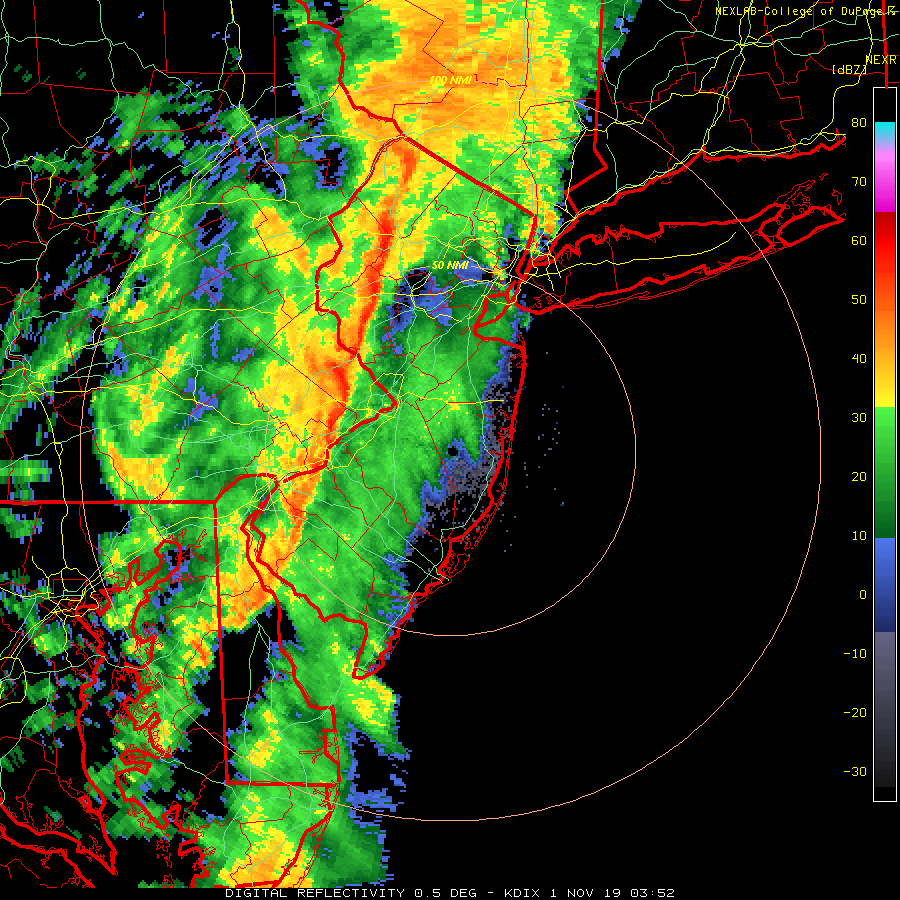
-
October 2019 General Discussions & Observations Thread
Gravity Wave replied to Rtd208's topic in New York City Metro
Lots of flash flooding reports in PA with this line. 2-3" being dropped on saturated ground in a short period of time. -
October 2019 General Discussions & Observations Thread
Gravity Wave replied to Rtd208's topic in New York City Metro
This outbreak today isn't going to be a joke from the Mid Atlantic. Second straight year with a big autumn severe outbreak in the region after last October's tornado outbreak in PA. -
October 2019 General Discussions & Observations Thread
Gravity Wave replied to Rtd208's topic in New York City Metro
I think this has been discussed a lot on here before but isn't the general consensus that the sample size of winters with notable October-November snowfalls for the NYC area is too small to draw any meaningful conclusions about how such a winter will turn out? -
October 2019 General Discussions & Observations Thread
Gravity Wave replied to Rtd208's topic in New York City Metro
OK, thanks for the update.


