
turtlehurricane
-
Posts
5,005 -
Joined
-
Last visited
Content Type
Profiles
Blogs
Forums
American Weather
Media Demo
Store
Gallery
Everything posted by turtlehurricane
-
The low pressure that is going to usher in the cold front is taking shape over Louisiana, and will rapidly deepen as it ejects up the east coast https://weather.cod.edu/satrad/ It's exciting to see that it's actually happening. Time for this long hot summer to end!
-
Today was a weird day. We're not in a cold air mass at all obviously, but there was a deck of low clouds all day and temps were in the upper 70s. Basically even without cold air advection the really low sun angle this time of year is making its presence felt. It felt room temperature outside, no warmth at all but not cold either. NWS calling for upper 40s Wednesday morning here. That will be such a drastic change, it will feel frigid after how warm this year has been. Behind the front, high pressure builds back across the peninsula, with northwesterly to northerly flow advecting a colder and drier airmass into the region. The coldest temperatures should be felt Wednesday morning with overnight lows dipping into the upper 40s to lower 50s across coastal metro areas and mid to lower 40s over the interior and western Lake Region. This will be somewhat short- lived as high pressure slides further eastward, veering the flow out of the northeast then east, essentially inciting a warming and slight moistening trend as the airmass modifies by late week.
-
Miami NWS discussion this morning. I'm excited. Behind the front, some drier air will move into the area and the mid- level low will be north of the region, which should allow for lower rain chances mid next week. Wednesday and Thursday are trending cooler with morning lows in the 40s and 50s on Wednesday morning and a few degrees warmer on Thursday morning. Tuesday and Wednesday`s afternoon highs will struggle to reach the upper 60s and lower 70s across the region as well with gusty northwesterly to northerly wind. Thursday should also be a drier day, though temperatures will be warming up.
-
Even when it gets down to just 70 it feels cold to me! We had a morning or two near 70 this year so far and it felt pretty much chilly. As for the coming event, it seems the GFS has gotten stronger with the cold airmass as the event has gotten closer. Looks like a potential freeze in northern Florida is on the table. This will be an extremely drastic change here, going from no cold fronts at all to a legitimately strong cold front. Also, based on GFS, looks like cold air will stick around. Basically going from Summer to Winter in just one day.
-
Many years ago I created a South Florida Winter Thread. In-fact, it was so long ago it may have been on EasternUSWX. Now I'm bringing it back, because I love posting winter observations, and discussing winter with other Floridians. Also, this time the thread will be for all of Florida, including South Florida, Central Florida, Northeast Florida, and the Panhandle. The reason I am making this thread now is that the GFS shows the first powerful cold front of the year crossing through the state a week from now. Notably, up to this point it's been the warmest Autumn in history in Southeast Florida. We usually get our first good cold front in October, if not late September, but this year still no strong cold fronts. Indeed, it didn't even get below 70 until a couple days ago, when sites across Southeast Florida managed to get into the upper 60s during the early morning hours. Let the Florida winter discussion begin! People from up north may make fun of our winter, but I find it absolutely fascinating. Hopefully we get some freezes, and maybe even some flurries!
-
Lowest temperature so far this year around Fort Lauderdale is 70 F. I don't remember a year like this ever in my life. We usually get the first good cold front, with some 50s or 60s, in October. This year no real cold fronts so far, and none in the forecast.
-
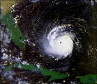
Satellite makes it look like it's coming right back towards South Florida. Lol. It is east of the cone, but probably won't miss the track by that much.
-
2020 Atlantic Hurricane Season
turtlehurricane replied to Windspeed's topic in Tropical Headquarters
The general rule for when hurricane season ends is when a cold front gets all the way to Puerto Rico. The crazy thing is we've had just one cold front here in Southeast Florida, and temperatures did not even drop below 70 F. This is highly unusual. Sometimes we'd get our first real cold front in mid-late September, almost always we get the first real cold front in October, this year it's now mid-November and we haven't had a real cold front. Further, no cold fronts at all expected for over a week. In-fact, I don't recall this ever happening in my life before. By now we should have had a few cold fronts and winter/dry season should be solidly underway. -
The most notable thing about Eta in my opinion is how it truly brought tropical storm conditions. Basically, there's not much in-between getting barely any impacts at all and getting hurricane impacts, and in this case we actually got tropical storm impacts, which is a rarity. From what the news says there was severe flooding in my area, and many people had their houses destroyed by flood waters. Indeed, I drove around this evening to do some errands and there was extremely deep floodwater in spots, even in spots where they are actively pumping the water. We are getting another band here with torrential rain, after a rain-free day. Looks like as Eta drifts north we could get torrential feeder bands from time to time. Flood warnings and flood watches are still in place.
-
The tree is fine thank God. I got 15 avocados here inside, only a few stubborn ones left on the tree. I was just out there remarking on how these are definitely the highest winds of the day. The wind is roaring through the trees and I'm hearing the hurricane howl every few minutes. Indeed, a site on the coast in Ft Lauderdale just recorded 66 MPH. https://mesowest.utah.edu/cgi-bin/droman/meso_base_dyn.cgi?stn=AU497&unit=0&timetype=GMT Things really intensifying as this primary convective band moves in. I think we could reach hurricane force in the coming hour once this band moves in. Also tremendous potential for flooding, it is at the exact right configuration to train over us. P.S. Recon confirms that the nice looking eye feature that is about to make landfall in the Keys only has winds of 40-50 MPH. The real action is up here in Dade/Broward/Palm Beach. I think recon will fly through this band and check it out.
-
Powerful deep convection, the deepest convection in the whole system, is firing in a band north of the center, and this feature will hit the SE FL coast. This band may have the most powerful winds in the entire storm. https://weather.cod.edu/satrad/?parms=meso-meso2-14-200-1-10-1&checked=map&colorbar=undefined Already the conditions out there are solidly tropical storm force, with lots of wind and torrential squalls moving through very often.
-
Precisely... this puts SE FL in the prime spot this evening through tomorrow morning for Hurricane force wind gusts. It should be noted that although the latest model guidance and track forecast shows landfall in the Florida Keys, the strongest winds are occurring, and are expected to occur, well to the north and east of the center.
-
There's still plenty of convection, it's just occurring in the bands north of the center. This is what sub-tropical systems look like. There are extremely powerful squalls in that convection, looks like it'll be on the SE FL coast within a couple hours. We could get hurricane force gusts from those. In the meantime we are getting constant tropical storm gusts and light-moderate rain. I do wonder how NHC will react to these changes though. I don't think a sub-tropical transition was exactly what was expected.
-
Actually, I think it is a classic case of a sub-tropical hurricane at this point. That's why the impacts are happening at such a large radius, and why it's intensifying without much central convection.
-
Wow! How high was the wind you think? Inner rain bands starting to move onshore in Broward and Dade, tons of embedded squalls with not much breaks between them. Also, the eye has finally appeared on Miami radar
-
Eye is starting to clear out on visible. Although deep convection is not that impressive, it is apparent that Eta is continuing to organize and strengthen. https://weather.cod.edu/satrad/?parms=meso-meso2-02-200-1-10-1&checked=map&colorbar=undefined Upper level dynamics are creating a perfect storm sort've scenario with this one.
-
Another very intense band just moved in. Wind is really starting to get powerful, to the point that it's roaring. Power was making weird noises as the strong winds hit, not sure how much longer it can hold out. According to FPL roughly 10,000 people have lost power in Southeast Florida, a number which is quickly rising. https://www.fplmaps.com EDIT coastal site in Fort Lauderdale gusted to 52 MPH on that one. I bet if there was a station down on the coast in Hallendale/Hollywood it would've recorded 60+ MPH EDIT 2: Hollywood North Perry Airport, a station well inland, gusted to 53 MPH from that squall. Confirms that winds were over 60 MPH on the beach.
-
It in-fact got MUCH better organized over Cuba, and that organization trend has accelerated as it's moved into the Florida Straits. This is a major development. The inner core does not look sheared at all, and shear is projected to decrease from here. Significant potential for strengthening to 100 mph in my opinion.
-
Fort Lauderdale International Airport (FLL) has been closed due to flooding. ...FLOOD WARNING REMAINS IN EFFECT UNTIL 1030 AM EST THIS MORNING FOR BROWARD, NORTHERN MIAMI-DADE AND SOUTHEASTERN PALM BEACH COUNTIES... At 938 AM EST, Doppler radar indicated an area of very heavy rainfall across the warned area. Between 1 and 3 inches of rain have fallen. Fort Lauderdale International Airport has reports of flooding along Perimeter Road near the Cell Phone Waiting area and is now closed due to standing water/flooding. Also short term forecast is juicy. At 929 AM EST, Doppler radar indicated showers over the Atlantic waters, moving west at 45 mph. Through the next few hours, this activity will continue affecting portions of eastern Inland Broward County, Coastal Broward County, Metro Broward County, Metropolitan Miami Dade, northeastern Inland Miami-Dade County and northeastern Coastal Miami Dade County. Very strong to at times damaging wind gusts, funnel clouds, and locally heavy rainfall, along with reduced visibilities, may accompany this activity. The potential for 45 to 60 mph wind gusts with the stronger showers is likely and impactful flooding is also likely if the heavier showers were to repeatedly move over the same locations.
-
It's impressive that this is bordering on hurricane intensity, if not already a hurricane if we had better sampling of the storm's wind field, and it still has the entire Florida Straits to cross. Convection continuing to deepen and expand near the center, it happened extremely fast, like the moment it moved back over the ocean, thanks to the powerful upper level support and the steaming hot waters.
-
New hot tower going up as Eta emerges into the Florida Straits. Here we go! https://weather.cod.edu/satrad/?parms=meso-meso2-14-48-1-10-1&checked=map&colorbar=undefined
-
This latest intense squall is so strong it's showing up on satellite, and we definitely just had some new peak gusts of 50-60 mph. 5 avocados came down all at once, now up to 12 avocados from this hurricane. Confirmed: An accurate weather station near me on the coast recorded 60 MPH https://mesowest.utah.edu/cgi-bin/droman/meso_base_dyn.cgi?stn=AU497&unit=0&timetype=LOCAL
-
Not only are we in a shield of constant light to moderate rain, but the intense squalls are becoming much more frequent. We've had 3 bouts of torrential rain and tropical storm winds in the past 30 minutes or so. I think it's becoming a much stronger experience here due to Eta's center emerging into the Florida Straits, so Cuba is no longer blocking the circulation. Once Eta fully emerges into the ocean, and starts firing new hot towers and begins intensifying again, it may get much more wild here.
-
One thing that is becoming clear as the first visible images of the day come out is that this is vertically stacked, no naked swirl situation. Also, with visible it's fairly easy to see where center is, and it already looks like the center is about to emerge into the Florida Straits. https://weather.cod.edu/satrad/?parms=meso-meso2-02-24-1-25-1&checked=map&colorbar=undefined
-
Constant light to moderate rain now with no breaks, with intense squall lines embedded. Looks like a couple big ones came through in the hour right before I woke up, and that's probably been happening all night. Notably, winds are persistently gusting to 40 MPH, even outside of the squall lines. I found 3 more avocados when I woke up. As for Eta, convection is dying down a bit as it crosses Cuba, but it is still looking impressive and well-structured, and probably ready to flare up as soon as it moves into the Florida Straits later this morning. I think as soon as it moves into the straits winds will get much stronger here.
