turtlehurricane
-
Posts
5,005 -
Joined
-
Last visited
Content Type
Profiles
Blogs
Forums
American Weather
Media Demo
Store
Gallery
Everything posted by turtlehurricane
-
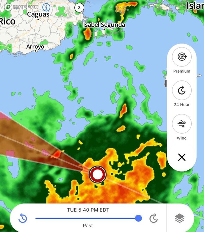
NHC now showing the official center is well to the north of the previous track, and winds have been upped to 40 mph

-
The center approaching eastern Puerto Rico is definitely the real center. Recon will confirm in 2-3 hours
-
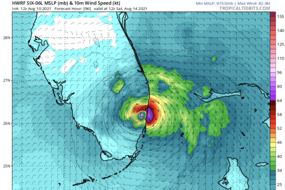
Surface center becoming apparent now. It's WAY north of NHC center. Looks like the HWRF SE FL Major Hurricane scenario is actualizing itself.
-
Yes, and the recon data was ingested into the 12z HWRF. They were saying that this 12z HWRF would be the clearest picture we had yet of what would happen, and they said that before the run unfolded. They must be very surprised at the results.
-
By tomorrow we will know for sure what's gonna happen, cause by afternoon/evening it will have either went north of Hispaniola or right into Hispaniola. Even by tonight things will become clearer. If center crosses central/eastern Puerto Rico, then it will miss Hispaniola. If it crosses westernmost Puerto Rico, or even goes west of Puerto Rico, then it's hitting Hispaniola, and weaker solution shown by NHC 11 am advisory would unfold.
-
Storm is actually coming on Shabbos so I won't be posting at all when it comes in. Good thing I just got a weather radio, so I can receive the NHC and NWS updates during Shabbos without touching any technology. After work today I am definitely stocking up on water, bread, and non-perishables, by tomorrow stores will be cleared out the way this is looking.
-
12z HWRF takes it right into me as a major hurricane. I'm starting to get quite excited! 5 pm advisory will obviously shift track towards SE FL.
-
Wow, shear wins. I've never seen a hurricane get smushed like that. Like a bug against a windshield. I'd be so depressed if I was chasing this thing or if I lived in Tampa, would be the same feeling as doing an entire 8 ball of cocaine and running out.
-
Elsa took a big jog to the NW just now on radar. Tampa definitely has some sort of deflector shield
-
A band is coming through SE FL now. heavy rain but absolutely zero wind. Overall Elsa has been extremely underwhelming here. Plenty of sea breeze storms have had a much bigger impact than this. I guess all eyes on Tampa, to see if it floods the bay there. Probably not, it’s not that big of a storm, but we’ll see
-
If it's going this slow over the Florida Straits things could get crazy fast, the Gulf Stream is nuclear hot right now. Intensity models / the NHC are underestimating it cause of the 'shear', but shear can help fuel rapid intensification in the right circumstances, like Hurricane Humberto in Texas many years ago. And yeah, all the convection is happening downshear in NE quad, dragging storm towards the NE. Key West better be taking this storm seriously.
-
NHC 5 pm position solidly north and west of actual center. They’re just extrapolating in lieu of recon data... but yeah.
-
The shear vector, I.e. the jet stream, could push Elsa well east of track and slow it down. That plus the effect of weather enthusiasts on the entire Florida peninsula praying for it to go east of track.
-
In the first rainband here. Some nice breezes, some spurts of heavy rain, nothing crazy yet. I see some Mesowest sites gusting to 40 mph though in Broward, in the heavier cells in the band. This is nice, but the downer is that there's no bands behind this at all. So will be a long time till we see anymore action.
-
Elsa has connected with the Jet Stream. This could help fuel intensification and expansion of the storm, and it will particularly enhance rain/wind coverage in the NE quadrant. Very exciting stuff!
-
You are in space too. Everyone is in space. Space is all around us, and no one isn't in space. Starting to get a nice breeze here in space, maybe gusts of 20 mph. The first real signs of Elsa's circulation. Clouds rotating cyclonically through the sky too. Radar shows a fresh outer band shooting through Florida Straits.
-
Well, that aggressive outer band fell apart, and all we got was a sprinkle around sunrise. Now a very light easterly wind and sunny. That being said, we're getting tons of daytime heating now, and when the next convergence bands roll in it will probably be an explosive squall event. Might take till many hours from now for that to happen tho, since radar is pretty much empty between here and Cuba. I guess the real storminess will start here tonight once Elsa enters the Florida straits.
-
Vigorous outer rainband pushing towards SE FL coast. Right now it's hitting Bimini. Remains to be seen if it will get all the way here, but I think chances are it will since this band has been steadily intensifying, and it has some very deep convection. There have been several times in my life where an approaching cyclone sends out a really aggressive furthermost outer band, and it can catch people by surprise with winds of 40-60 mph, downed trees, power outages, etc... I think this could end up being one of those cases. Aside from that, another smaller band taking shape over Florida Keys and extending into coastal Miami-Dade. So impacts are just beginning now for SE FL. Perfect timing, will clear out all this smoke from the fireworks as soon as we get a band.
-
Cuban radar page will be very useful for tracking Elsa over the next day http://www.insmet.cu/asp/genesis.asp?TB0=PLANTILLAS&TB1=RADARES Elsa deserves some sort of medal for threading the needle 100%. It really missed all the landmasses in the Greater Antilles. Radar shows its off to the west of the Cuban mountains now. Anyone remember a storm threading the needle like this? I sure don't.
-
Went to Walmart and all the water is gone. Main effect of Elsa so far in SE FL is the subsidence ahead of the storm is causing the highest temps of the summer so far. Heat index 103 F... on a normal day it starts storming before it ever gets this hot, but Elsa is stopping any storm development. Elsa’s outer bands are just starting to spread through the Florida Straits, might take till tomorrow morning to see any action tho at the slow speed this storm is moving. Most importantly, Elsa is starting to look really impressive, it’s expanding in size and organizing quickly, and I’m starting to get excited, especially cause it’s past all the mountains now.
-
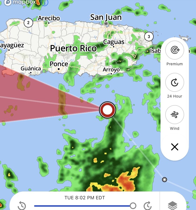
You can basically see where the center is on Guantanamo radar. Seems like Elsa will perfectly thread the needle between Jamaica and Cuba! Also radar structure is fairly nice. https://www.metoc.navy.mil/fwcn/animate.html?icao=mugm&type=CMaxZH240
-
Upper level outflow improving. If it can tap into that jet stream over Florida it could intensify rapidly, but no guarantee that will happen.
-
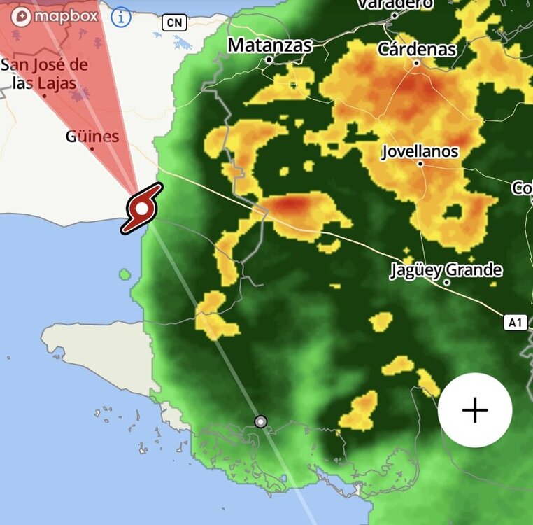
Back from Shabbos. Ran right into the mountains it seems. Nice convective blowup, but the convection is likely anchored to the mountains and might not move with the storm. Then it’s gonna run right into the highest mountains in Cuba, while slowing down drastically. Pretty much no opportunity to strengthen until Monday afternoon when it enters the Florida Straits.... lets see how much of it is left by then... it is already much smaller and way more disorganized than yesterday.
-
Here comes Shabbos, no internet for 25 hours. Looks like when I come back that’s when Elsa will be riding right into the mountains of Hispaniola, so even then we still won’t know what’s really gonna happen with this thing. ive yet to see a storm take this path and do anything significant to SE FL. Probably will be a big disorganized tropical storm coming through the Florida straits and that’s it.
-
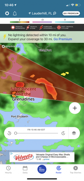
Direct hit on St. Vincent. Same island that had a massive Volcanic eruption this year