turtlehurricane
-
Posts
5,005 -
Joined
-
Last visited
Content Type
Profiles
Blogs
Forums
American Weather
Media Demo
Store
Gallery
Everything posted by turtlehurricane
-
Seems like the track has shifted east with every model run. I'm starting to wonder if it might go due north into Florida. Probably not, but kind've looks like that on satellite. Anyone here have any theories why the track keeps shifting east as this comes into focus?
-
2021 Atlantic Hurricane season
turtlehurricane replied to StormchaserChuck!'s topic in Tropical Headquarters
A vigorous tropical wave/disturbance is pushing into Florida right now. Winds sustained near 20-30 mph and tropical storm force gusts here in SE FL. It's only just getting started, main impacts look to hit tonight. -
GFS keeps shifting west. Last night it was eastern New England, today New York City. In a couple more days we will know for sure, but I’ll say now this has a high probability to be the Northeast Hurricane that all the weather enthusiasts up there have been waiting for.
-
2021 Atlantic Hurricane season
turtlehurricane replied to StormchaserChuck!'s topic in Tropical Headquarters
There’s a tropical cyclone at each corner of the Bermuda Triangle!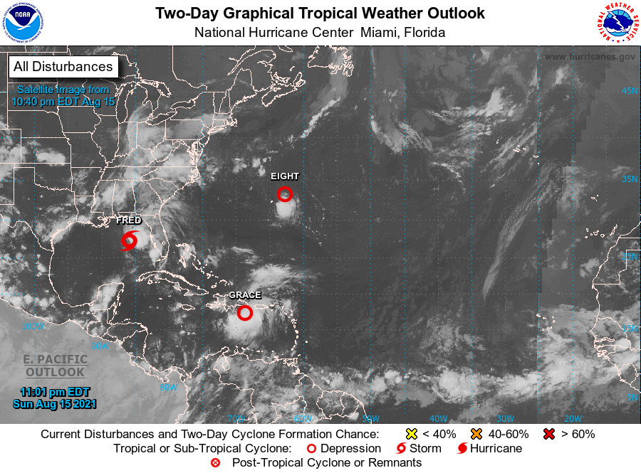
-
Gosh, huge convective blowup over the region that got the Earthquake. The start of days of torrential & life-threatening rain. https://weather.cod.edu/satrad/?parms=subregional-E_Antilles-14-12-1-50-1&checked=map&colorbar=undefined It seems the convective blowup north of the Greater Antilles has lost organization, southern center has taken over. Therefore, the small probability that this would re-form north of Hispaniola is evaporating. It could still be a big deal in the Gulf of Mexico (or nothing at all, it could die), but either way, this doesn't look to be anything for Florida, not even as much as Fred.
-
I know a lot of you have probably thought of this, cause it seems like these events happened too close together to be a coincidence. Therefore, I'd like to start a scientific discussion in this thread, about how Tropical Cyclones can potentially cause Earthquakes, and in this particular case, it seems possible that Tropical Storm Fred caused an earthquake in Haiti. Haiti did get a tremendous amount of rain in Fred from Wednesday-Thursday, and on Saturday the Earthquake happened, a mere 2 days later: https://earthquake.usgs.gov/earthquakes/eventpage/us6000f65h Maybe the flooding rain and mud/land slides caused something to shift enough to spark a huge earthquake?
-
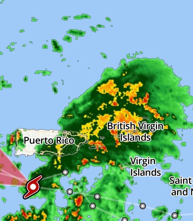
The lack of a well-defined center, and the vigorous convection passing to the north of the Greater Antilles, is an ideal setup for Grace to gracefully glide over Hispaniola and begin intensifying as it enters the Bahamas.
-
One huge difference between Fred and Grace, is that Grace has a strong and organized area of convection that is on track to go north of the Greater Antilles. This drastically increases the probability of a center reformation north of Hispaniola https://weather.cod.edu/satrad/?parms=subregional-E_Antilles-01-12-1-50-1&checked=map&colorbar=undefined
-
NHC has shifted track north, I’m now in the cone! New track is just slightly south of HWRF scenario. It will really all come down to whether Grace goes into Hispaniola on Monday, or if it passes to the north. Notably, Grace passing through Hebert Box right now, which favors that it will hit South Florida... unlike Fred which formed west of the box and technically did not pass through it.
-
Well, the HWRF has managed to illustrate every possible scenario. It's been all over the place. Just saying, what's going on now with center re-formation near the Keys is one of the scenarios from previous runs.
-
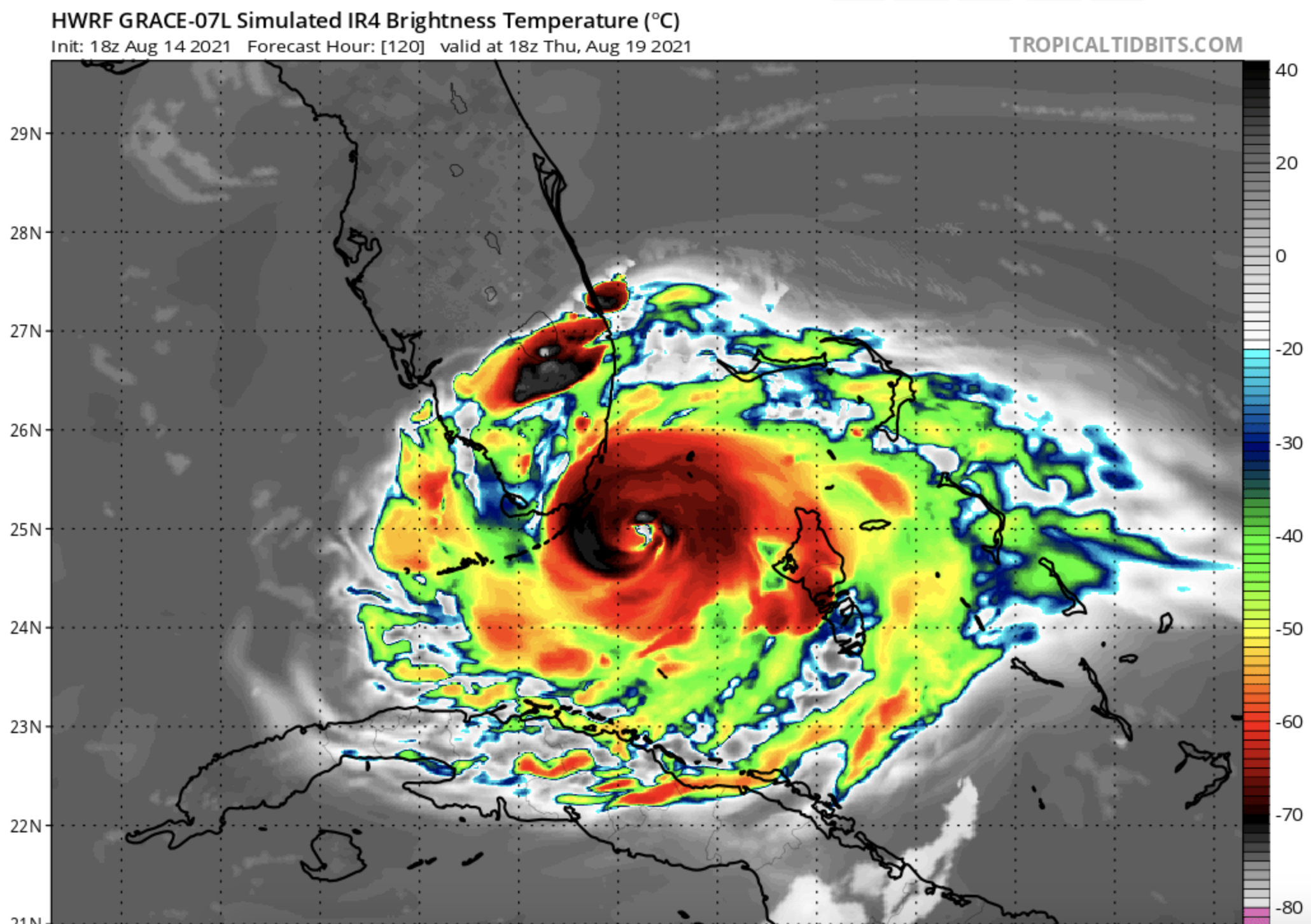
The ever-bullish HWRF takes it north of the Greater Antilles and brings it into South Florida as a powerful hurricane https://www.tropicaltidbits.com/analysis/models/?model=hwrf®ion=07L&pkg=satIR&runtime=2021081418&fh=-6 Feels like we're caught in a time loop, like a version of Groundhog Day with tropical cyclones that seem like a serious threat but end up dying over Hispaniola.

-
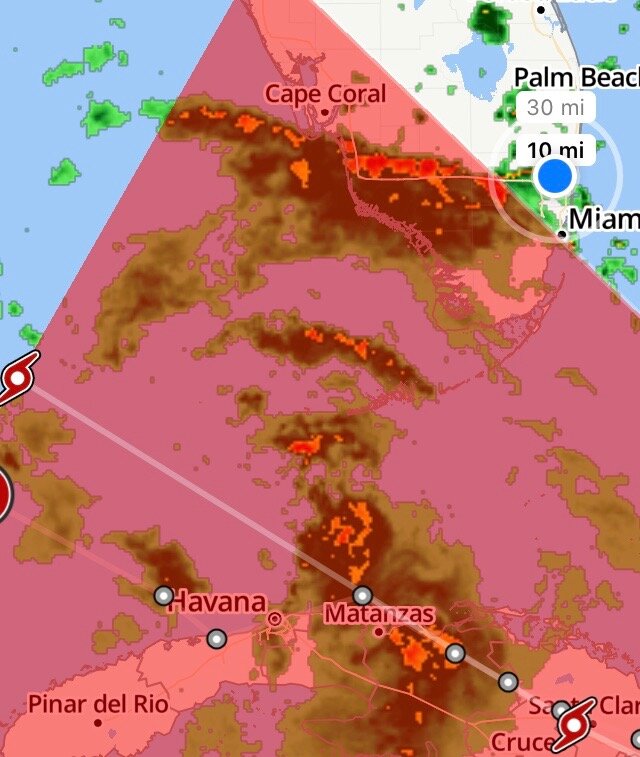
A really awesome squall line just came through, torrential sideways rain, a stiff breeze near tropical storm force. It was worth the wait. Even though this is a disorganized wreck, the rainbands are stronger than a lot of the hurricanes that have near-missed us in the past. The atmosphere is just really juicy and unstable. Yeah this thing definitely has bans, a big one over South Florida, another over the Keys, and some inner-bands near the reforming center north of Havana. The HWRF actually showed this scenario on some runs, where center reforms and moves due north from Cuba to Florida West Coast.

-
Well, we got some drizzle last night, not a drop of rain today at all! Just breezy with lots of clouds. It looks like some bands are finally going to be moving in though, lots of lightning flashing through sky and winds picking up. BTW, Key West Radar indicates that Fred is re-forming WAY to the east of it's current center fix. Basically the new circulation is moving due north from Cuba towards the Dry Tortugas. So expect a huge track shift.
-
Well Shabbos is starting. Turning on the weather radio for the duration of the Shabbos, and gonna hunker down! Kind've fun going through a storm without internet. When the squalls hit it will be a surprise every time. I'll report back tomorrow night!
-
The band is evolving. Really cool to look at. @Prosperonote the flock of ibises that just descended. Your hungry bird theory, plus the fact that the Ibis is the mascot of the Miami Hurricanes, is a double indicator that wicked awesome weather is on the way
-
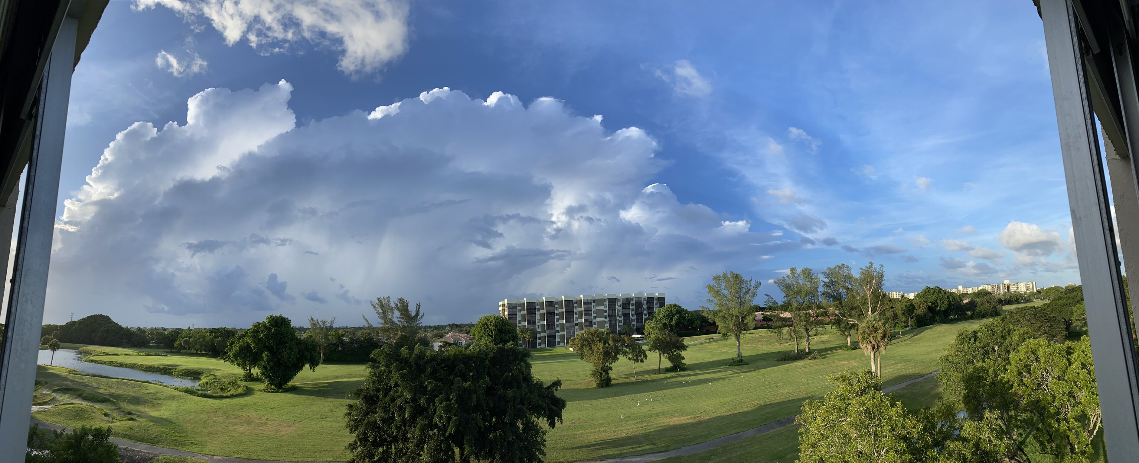
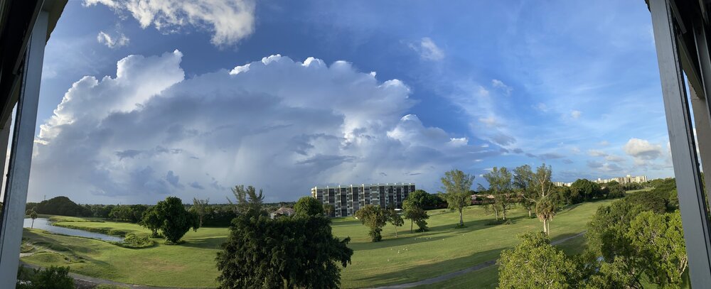
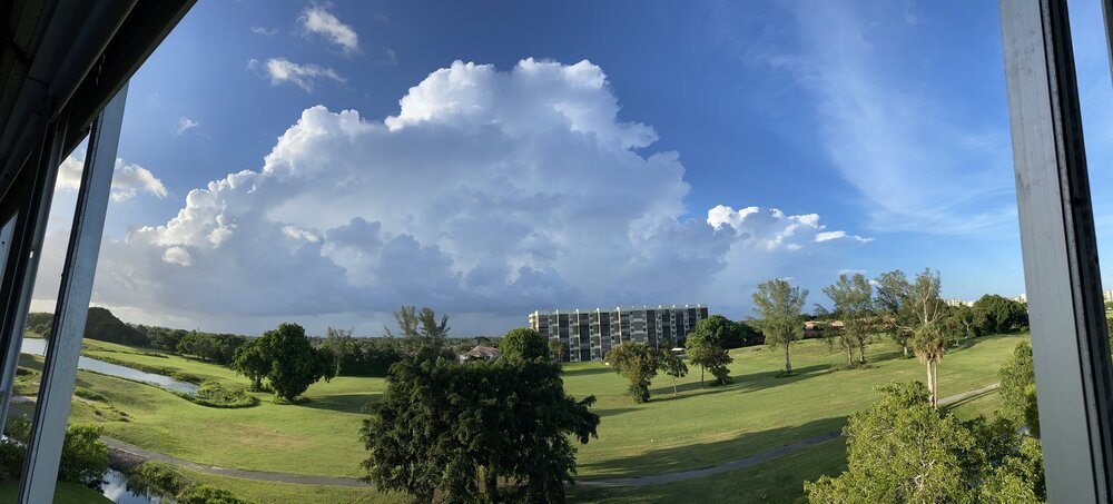
Panorama of one of Fred’s outer bands Note, on right side of the pic is a big branch or tree that fell down last night.
-
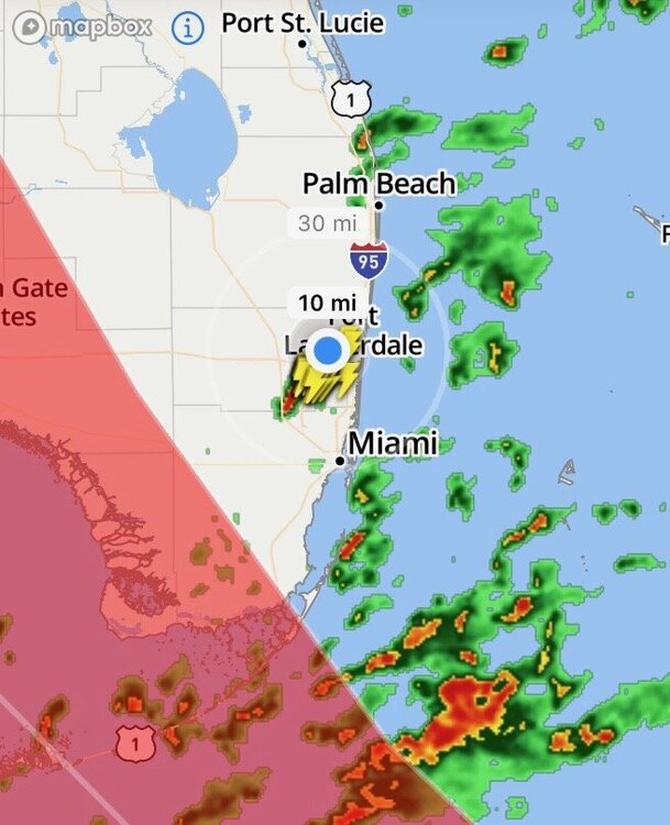
My wife feeds the birds too, we got flocks of ducks, geese and ibises. They are eating more than ever. Satellite shows the rainbands quickly crossing from the Bahamas to the SE FL coast. We just had our first big thunder roll as I typed this. Radar shows a band has just popped up in northern Broward. DMAX starting with a bang! https://weather.cod.edu/satrad/?parms=subregional-Bahamas-01-48-1-50-1&checked=map&colorbar=undefined
-
Indeed, the satellite presentation is more impressive than ever. Also, banding north of the center getting increasingly vigorous, and it seems we are on track for crazy weather in SE FL starting late tonight. Especially as DMAX kicks into gear. Just went to Publix and stocked up, I have enough food, water, bread, Marijuana, and Kratom to survive this storm no matter what happens.
-
It's starting to look like a bonafide tropical cyclone again https://weather.cod.edu/satrad/?parms=subregional-Bahamas-01-48-1-50-1&checked=map&colorbar=undefined Not sure exactly what's happening but it's sending out spiral bands in all direction, including the entire Cuban Seabreeze front which has effectively become a spiral band. Starting to get excited again. That whole mass of weather is coming towards South Florida.
-
The center of circulation is literally dissolving into a Seabreeze front over Cuba. That's a new and unique way for a tropical cyclone to die. It could reform of course near South Florida, like models are hinting, but it really wouldn't be the same storm anymore. Still very interesting weather coming, that wave is looking very juicy, and it'll crash into the upper low and create tropical storm conditions here even if there is no defined circulation.
-
Circulation center is going fully inland over Cuba. The associated wave axis, north and east of the center, is far more impressive and has lots of convection. I guess even if it totally dies over Cuba that wave will still hit South Florida and bring the floods.
-
GFS has a Floyd/Dorian scenario, where it comes right up to the SE FL coast as a hurricane and then turns hard to the north. Those are the worst, I'd rather this storm just dissipate now so I don't have to go through such a tease.
-
We had some wicked storms last night around 2-4 am. I was only awake a minute and remember tremendous rain and wind. Morning visible shows circulation making landfall on northern coast of Cuba, devoid of all convection. Shear was just too strong after all. https://weather.cod.edu/satrad/?parms=subregional-Bahamas-01-12-1-50-1&checked=map&colorbar=undefined Still will be some really interesting weather according to HWRF, it shows Fred basically reforming over South Florida, with rain and convection beginning to inundate SE FL late tonight and increasing through Saturday, with center re-formation near Naples. Flood watch is in effect cause of this, 4-7 inches of rain expected! And we already got a widespread 1-2 inches last night according to rain gauges.
-
Fred definitely being upgraded to TS at 11 pm, 40 mph SFMR on latest pass
-
That upper-low/trough over Florida is interacting with Fred's circulation and creating a huge area of severe squalls. They're starting to come in all across the coast now. We just got clipped by the edge of one of the squalls and for a few minutes it was absolutely torrential rain and winds of 30-40 mph. Can't imagine what it was like in the center of the actual squall, but I'll find out soon, lots of squalls coming. This definitely increases flooding potential. Could be quite a flooding event starting now actually, I think conditions are becoming increasingly favorable for these squalls as Fred and the trough collide. Also sporadic power outages seem likely, these squalls are packing winds of up to 40-60 mph. P.S. lightning and thunder filling the sky, it's pretty awesome.