turtlehurricane
-
Posts
5,005 -
Joined
-
Last visited
Content Type
Profiles
Blogs
Forums
American Weather
Media Demo
Store
Gallery
Everything posted by turtlehurricane
-
Convection already dragging the center north and East. If convection can really lock in over center during DMAX it will drag it big time. Shear vector is definitely not something to under-estimate.
-
You can just stay in Islamorada for now, if it ends up going north of track you'll have time to react. Remember, even in a hurricane warning, people are allowed to drive out of the keys. It won't be closed. I don't think any hurricane advisories are coming until tomorrow once it's already becoming a hurricane, if that happens. At 11 pm or 5 am they will probably put tropical storm advisories for SE FL
-
Not even the bullish HWRF runs from previous days showed deep convection going up this quick over the center. Also, deep convection will drag circulation northwards and eastwards due to shear vector. I have a very strong feeling we could have a hurricane in Miami. All the ingredients for a big surprise are in place.
-
NHC finally issues tropical storm watches for the Keys, but completely excludes SE FL. They're too conservative, it's ridiculous to think that there won't be tropical storm conditions in SE FL when most of the convection and bands will be on northern side of the circulation. There's still even a chance that Fred's center will go into SE FL once it becomes more vertically stacked and gets caught in the upper steering currents, like the HWRF scenario from the past few days. So they're setting up SE FL for very short-fused watches and warnings, with barely any time to prepare. I think they will rectify this at 11 pm - 5 am though cause this storm will be exploding with convection by then. Btw, DMAX is starting. Deep convection going up near the center. Game on!
-
This is essentially the first outer band to come through. It’s a quasi-band, it’s on the edge of Fred’s circulation. A whole lot more weather like this going to come in the next few days. I think this storm will be more intense than most people expect, it will be a “juicy” cyclone with tons of squall activity.
-
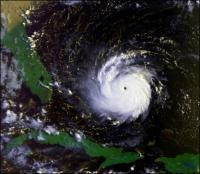
Looking at the visible loop of the full day, you can see that the circulation has expanded alot, and that thunderstorm activity is continually ramping up. At this point there's a nice convective band directly connected to the center in SE quadrant, and a large convective blowup in NE quadrant. It's obviously enough convective activity to increase the vorticity of the cyclone, which is why the circulation is steadily getting bigger. Very good setup for a powerful DMAX. https://weather.cod.edu/satrad/?parms=subregional-Bahamas-01-96-1-50-1&checked=map&colorbar=undefined
-
It's definitely looking better and better. Shower and thunderstorm activity increasing in all quadrants. Looks primed to have a massive convective blowup when DMAX starts in 5-6 hours.
-
There's no guarantees of anything. You will have to monitor closely on your chase, and position yourself in the right spot. Anywhere from Key West to Palm Beach is fair-game for landfall, and it might be anything from a tropical wave to a major hurricane. If I had to guess, I think Cat 1 into southern Miami-Dade. But that's just throwing a dart.
-
A convective band is forming in northern semicircle, just like the HWRF bullish scenario from previous runs. The less bullish HWRF runs we have now don't show this happening until tonight, so it's ahead of the game https://weather.cod.edu/satrad/?parms=meso-meso1-14-96-1-10-1&checked=map&colorbar=undefined
-
It is churning towards the Gulf Stream, the hottest water in the Hemisphere. What you mean?
-
NHC basically taking a wait and see approach before issuing any new watches/warnings anywhere, since this is barely a tropical depression right now. Watches/Warnings could end up being very short fused since this thing probably won't have any convection till tonight.
-
Even though it is a naked swirl now, I expect tropical storm watches for the Keys and SE FL at 11 am, since even if it doesn't have any convection all day, there will be a massive convective blowup during diurnal maximum tonight, giving Fred roughly 36 hours to intensify before landfall in South Florida.
-
If the bullish HWRF scenario (from previous runs) is accurate, then what will happen today is a band of convection will start flaring up over the Bahamas, and then over the course of 24 hours Fred will become organized again. So that's the thing to watch for. I think it's actually quite likely that Fred will intensify. It has alot of nuclear hot water to traverse. Once some convection flares over or near the center it's game on, and that's pretty much definitely going to happen since the water is so hot and there's ample convergence near the center. This time of year, even shallow little Seabreeze boundaries blow up into big convective complexes, let alone a circulation like this.
-
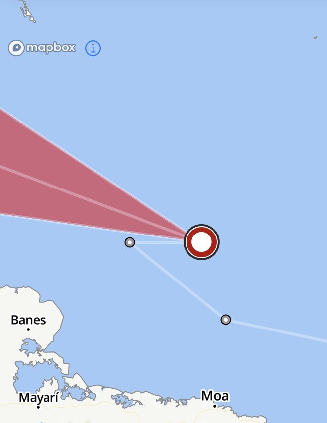
It looks like the center is over the Inagua Islands. Visible about to confirm, rapid scan visible link here: https://weather.cod.edu/satrad/?parms=meso-meso1-01-12-1-10-1&checked=map&colorbar=undefined Only problem is the storm has completely detached from its upper-level support and is in an environment of high shear, and has entrained lots of dry air. However, if the center really is over Inagua right now, then Fred will track right into Miami. And Fred has roughly 2 days to get its act together before landfall. Furthermore, if the circulation really did survive, that's a pretty big deal. We will know within the next 30 mins or so as sun rises.
-
Shortwave seems to show the ghost of the circulation emerging from the coast of northern Hispaniola
-
NHC generously downgraded Fred to a TD, when in-fact it is likely once again a ‘potential tropical cyclone’ NHC also fixing center on northern coast where we all see it.
-
There's some hints on Visible and Shortwave that whatever is left of the center is on the northern side of Hispaniola. It's very likely degenerated into an open wave for now, with solid easterlies on north side but no westerlies on south side.
-
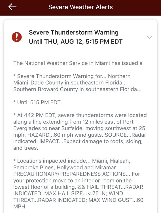
We have had a couple of wicked strong squalls come in off the ocean today here with tropical storm force winds, intense thunder/lightning, and absolutely drenching rain. Even though it is Florida, these storms are definitely abnormally strong, and squalls coming in from the ocean in the daytime is unusual. There's definitely a lot of 'juice' in the atmosphere. Also, I noticed there's a strange meteorological pattern taking shape north of Fred. I wonder if that's what the HWRF is sniffing out with the reformation and rapid intensification. That stuff north of Fred looks like ripe for TC genesis, and it's not far-fetched that it will happen like that once Fred moves a bit further north. https://cdn.star.nesdis.noaa.gov//GOES16/ABI/SECTOR/CAR/GEOCOLOR/GOES16-CAR-GEOCOLOR-1000x1000.gif
-
I think it is finally making northward progress too, instead of just hugging the southern coast. Everything is still really uncertain until it leaves Hispaniola, and once sun sets it's gonna be really hard to see what's going on. We'll have our answer once the sun rises tomorrow.
-
On the other hand, the HMON (GFDL) shows it getting shredded over Hispaniola, ejecting into Guantanamo Bay as a remnant, riding up the spine of Cuba as little more than a tropical wave, before eventually undergoing genesis again in the Gulf of Mexico. The HMON scenario is far more likely.
-
Basically, what HWRF is saying is that if any closed circulation of any sort makes it past Hispaniola, it will rapidly intensify over Florida Straits. Literally the HWRF shows it getting shredded and then slowly regenerating near Cuban Coast tomorrow, but once it does regenerate it's game on. We shall see. There's no guarantee of regeneration, and regeneration can take a very long time if it does happen.
-
I’ve been in the cone since Monday afternoon, but I’m very close to being de-coned This thing just does not have the veracity to push north across Hispaniola. It is stuck on the southern coast, just like it was stuck south of Puerto Rico yesterday. most likely scenario is it gets entangled in the mountains this afternoon and just stalls and dies, with some sort of remnant hitting Guantanamo bay tonight

-
It looks like it's committing suicide. Only 5-10% chance it emerges with a closed circulation. Will probably skirt along the whole southern coast of Hispaniola and hit Cuba too.
-
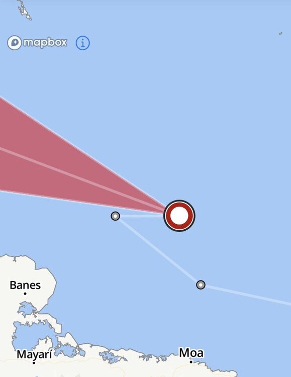
11 pm track nudged solidly north, brings it through the Middle Keys instead of near the Lower Keys. Of course that's all minutiae, main thing is to see how Fred responds to Hispaniola. It's still up in the air and 50/50 at this point. We'll see if it starts going north through Mona Passage once it clears Puerto Rico, or if it gets stuck south of Hispaniola. We'll have our answer by the morning.
-
Recon put in a center fix, Tropical Storm Fred at 11 pm.