turtlehurricane
-
Posts
5,005 -
Joined
-
Last visited
Content Type
Profiles
Blogs
Forums
American Weather
Media Demo
Store
Gallery
Everything posted by turtlehurricane
-
correct, not the classic definition of RI where an eyewall wraps around the center. However, partial eyewall formation likely beginning and the establishment of sustained deep convection.
-
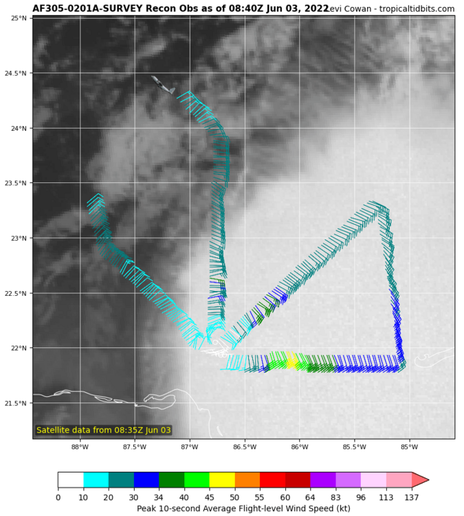
Recon heading out of Virgin Islands, could be a very interesting mission with RI starting. Track at this link Structure looks perfect for this thing to go nuclear. And if it does that tonight, I think it could be a Wilma situation for Florida. The earlier the storm gets deeper, the more east it will go
-
New TROPICS Satellites Going Up Soon
turtlehurricane replied to cptcatz's topic in Tropical Headquarters
Well that Astra one was a fail, but checkout this view from my balcony! -
2022 Atlantic Hurricane season
turtlehurricane replied to StormchaserChuck!'s topic in Tropical Headquarters
New tropical update, first one in a couple weeks. Not much going on, but I recap on TS Colin and TS Bonnie, and I explain that even though it seems quiet the real season has yet to begin, and that this low-level of activity in June/July is normal. -
2022 Atlantic Hurricane season
turtlehurricane replied to StormchaserChuck!'s topic in Tropical Headquarters
Tropical update for today -
New TROPICS Satellites Going Up Soon
turtlehurricane replied to cptcatz's topic in Tropical Headquarters
Well, I'm gonna have to disagree with you on the Falcon9 thing. We see every launch from here in the Miami area, as long as clouds aren't in the way. Here's an example of one I filmed As far as this Astra rocket, I won't claim to know for sure. However what I filmed is not a plane. It appeared at exactly when the Astra rocket launched. It disappeared at exactly when Astra separated stages and turned off thrust. Maybe it's an optical trick where it's really going east but looks like it's going west. Either way doesn't really matter, was just a cool thing to document. -
New TROPICS Satellites Going Up Soon
turtlehurricane replied to cptcatz's topic in Tropical Headquarters
And here's my video showing it going the wrong way. Big WTF all around -
New TROPICS Satellites Going Up Soon
turtlehurricane replied to cptcatz's topic in Tropical Headquarters
I briefly saw the rocket and got it pretty clear on footage, but it was going the exact opposite direction of what they said it would. They even have a live map thing showing it going east into the Atlantic and it was zooming straight west towards the Gulf of Mexico. Really odd! I'll upload shortly. -
New TROPICS Satellites Going Up Soon
turtlehurricane replied to cptcatz's topic in Tropical Headquarters
-
New TROPICS Satellites Going Up Soon
turtlehurricane replied to cptcatz's topic in Tropical Headquarters
It’s launching today, God willing, depends on weather always. Im gonna try to film it from my balcony. -
2022 Atlantic Hurricane season
turtlehurricane replied to StormchaserChuck!'s topic in Tropical Headquarters
The GFS was doing the same thing with Tropical Storm Alex. The time frame wasn't exact, and I think there was a pretty long delay between when the long-range runs showed it happening and when it actually happened, but the scenario ultimately played out. We'll see though. It's showing TC genesis in a week which is pretty far out. Once genesis comes into the 72 hour range it'll be more believable/serious. -
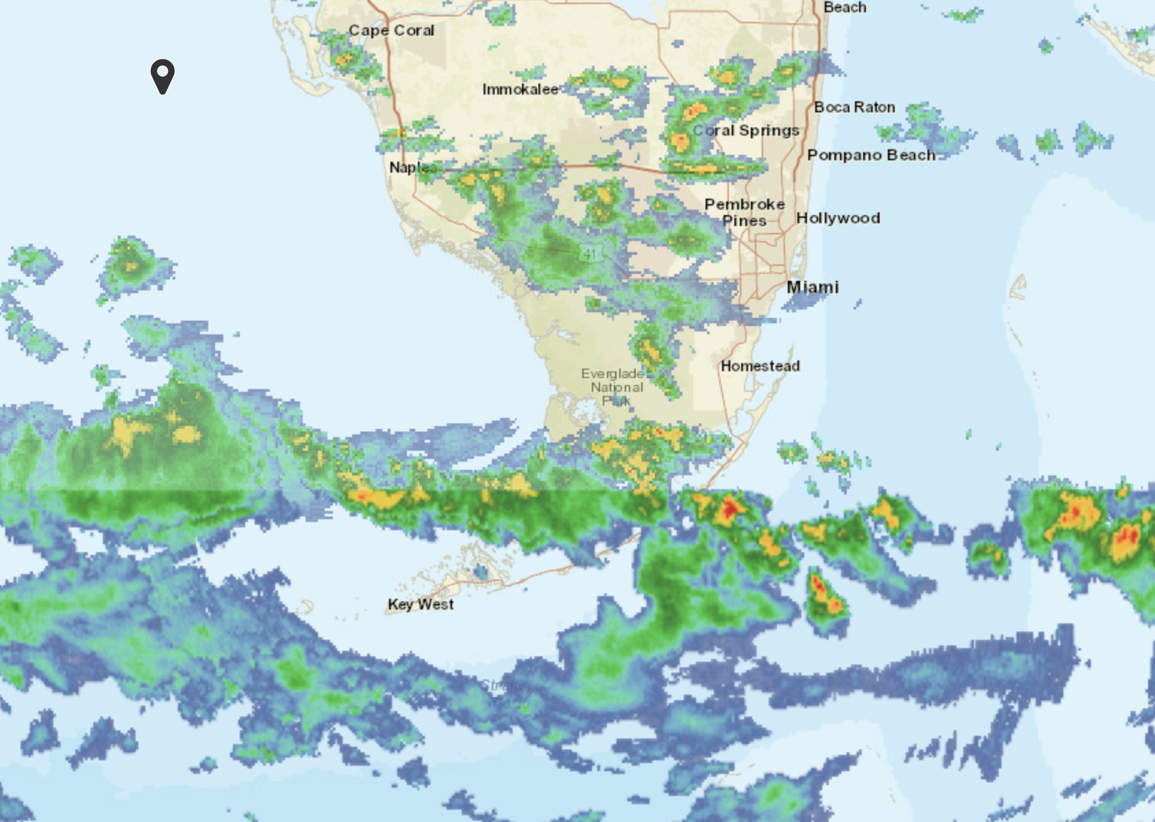
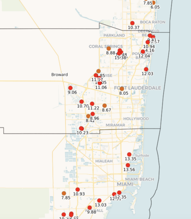
Well I'm back, was offline for 3 days due to Shabbos and the festival of Shavuot. This event was absolutely incredible. One of the strongest and longest rain events I've seen in my life. It just kept raining and raining and the water table rose to literally multiple feet higher than I've ever seen it before. It's too bad I couldn't take pics, but our little drainage stream become a full blown river, and streams/rivers were forming all over the place. All the lakes went out of their banks too, and maybe with another foot of rain everything would've went underwater. Parking garages started filling with water too. According to rain gauges we at least got a foot of rain, and there's a 16 inch bullseye not far from here. We were in the perfect spot to get trained on. All this being said, the water quickly went down on Sunday, and I assume the water management district let the flood waters out into the ocean, that's the only way the water table could drop by multiple feet so quick. I really wonder what happened in low lying areas that typically flood. Probably thousands of houses flooded, but I don't think such data is recorded that well. Finally, here's the epic radar loop of the event:
-
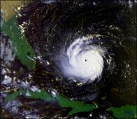
Live view inside the cyclone
-
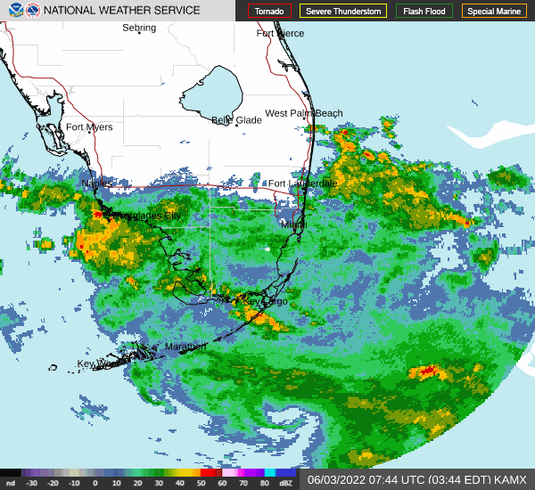
Last night the 'rain shield' moved in, more like the drizzle shield. It was drizzling for hours and hours. Then a few hours after sunrise we got a rainband with moderate-heavy rain, followed by more drizzle. Then another longer-lasting and heavier rain band moved in for awhile, but not torrential rains by any means. During all of that there were no winds. Now the wind has suddenly come to life and is blowing through all the trees, probably 15-20 mph or so. And a HUGE rainband is moving in quickly from Miami. Looks like this is where the flood threat begins.
-
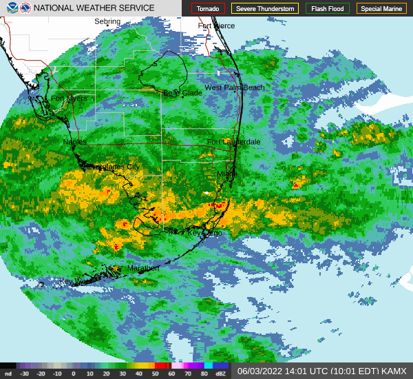
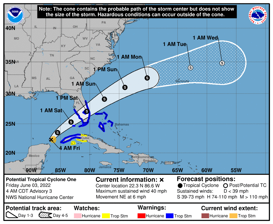
Tropical Storm Warnings now in effect for the Keys, all of South Florida, and alot of Central Florida. Track shifted a bit south, cause I wasn't even in cone before, but now I'm in the actual cone. Recon found that this has tropical storm force winds, but the center was ever so narrowly unclosed. However, in storm relative motion it obviously is a closed tropical cyclone. We could easily see this declared Tropical Storm Alex by 11 am. Also, really cool feature passing by South Florida right now. A secondary circulation generated by all the deep convection yesterday has become exposed, showing up good on both satellite and radar. And it has a decent amount of inclement weather swirling around it, so a big swath of rain is spreading over South Florida as this secondary mid-level circulation passes by. Of course, the fact such a feature exists is a tell-tale sign of the powerful shear that is warping this tropical cyclone. There is some serious diurnal max convection going up, but the convection is quite elongated and almost completely off to the east of the center. That being said, in a case like this, it's possible convection will wrap around center at some point, and I've seen scenarios where that leads to really fast intensification and very severe weather around the center in sheared systems.
-
My in-depth meteorological analysis for tonight
-
First outer rainband moving through right as Tropical Storm Watch was issued. Started with lots of rolling thunder, followed by a blast of 30 mph gusts and heavy rain, and now it's been a moderate rain for a long time. Very exciting stuff! Also, this rainband was the leading edge of the big cloud mass that comprises the storm. We're truly in the cyclone from now until it's over.
-
The remnants of Agatha essentially phased (combined) with the disturbance and now it's getting alot bigger and more impressive, like the ECMWF scenario. Outer bands already moving into the Keys and South Florida.

-
Don't know if NHC will pull the trigger at 5 PM but it probably is a tropical depression at this point.
-
2022 Atlantic Hurricane season
turtlehurricane replied to StormchaserChuck!'s topic in Tropical Headquarters
It really looks like it's getting its act together https://www.star.nesdis.noaa.gov/GOES/conus_band.php?sat=G16&band=GEOCOLOR&length=48&dim=1 Likely to be officially declared a cyclone today. GFS starting to align with ECMWF scenario of a more substantial system hitting Florida Saturday -
2022 Atlantic Hurricane season
turtlehurricane replied to StormchaserChuck!'s topic in Tropical Headquarters
My tropical update for the day. I basically see 2 scenarios, either it fights the shear and it's a disorganized mess like the GFS shows, or it links into the jet stream and becomes a powerful sub-tropical-ish system like the ECMWF shows -
2022 Atlantic Hurricane season
turtlehurricane replied to StormchaserChuck!'s topic in Tropical Headquarters
-
Central & Eastern Pacific Thread
turtlehurricane replied to Windspeed's topic in Tropical Headquarters
im starting to make video updates of all the hurricane related stuff going on, starting with Agatha! -
Cyclone quickly taking shape off SE coast. Forecast high of 53 tomorrow!!! Low 35. And it could easily trend lower cause of the volcanic winter situation. This is record shattering stuff. Coldest weather in 5-10 years at least.
-
Today was supposed to be sunny and 80 as warm air from tropics advected ahead of the front. Instead morning started near 60 with dense fog, and even though fog is lifting it's still stuck near 65 since there's tons of overcast. So a warm/hot day has ended up being a cool day. Just another example of a forecast busting colder. The 'bomb' cyclone is taking shape off the Florida coast and starting to lift northeast. Winds are increasing here as the cyclone strengthens. Cold front supposed to come in late tonight, will be 40s by morning, and then could hit the freezing mark Sunday morning.