turtlehurricane
-
Posts
5,005 -
Joined
-
Last visited
Content Type
Profiles
Blogs
Forums
American Weather
Media Demo
Store
Gallery
Everything posted by turtlehurricane
-
Massive cold front coming today, looks like the biggest one in the past 5-10 years. So I am reviving the thread We actually had a decent cold front a week ago too and I totally forgot to post in here. This is the volcanic winter for sure. Every forecast has been trending colder, and observations on the ground have been colder than forecast consistently every day and night. Sun is getting blocked out across the world by the Tonga eruption. The liberals are trying to play it down because it ruins the global warming agenda.
-
Winter is here!!!! Yesterday morning is when it really started. I woke up and there was a stiff wind gusting to 30 mph, overcast skies, and temps hovering in the low 60s. It felt absolutely frigid after the long hot summer we've been through. Eventually skies cleared and temps hit a high of 75, which was still fairly cold. This morning were getting our first 50s of the season. 57-59 F being observed across the SE Metro area as I write this right before sunrise. It's really really cold! We even got some 10-20 mph gusts rolling through making it feel even colder. I'm so happy the cold air is finally here!
-
NWS forecasting a FROPA Sunday night / Monday morning. However, only effect will be highs dropping from the upper 80s to the mid 80s, as well as some drier air. Further north, in Central and Northern Florida, most places will see lows in the 50s. Still no major cold fronts on the horizon, but they'll be coming soon enough.
-
Dewpoints went as low as the low 60s last night, temps went down to 70. Definitely the coolest and driest air in many months. Even though it is a very slight cold front, it is still very interesting, since it indicates that Fall is beginning. In less than a month we will probably have a 'real' cold front.
-
NE winds have intensified today and dew points have dropped as low as 70. First real FROPA!
-
Time to revive the Florida winter thread! We are getting our first northerly winds in SE FL the past day as a backdoor front sits over the area. Weve had tremendous rains and storms every day for the past several days due to this weather setup, as the continental air clashes with tropical air. Looks like front will push through a little more in the next day, and by tomorrow lows will be in the low 70s. Game on! I’m excited for this rendition of Florida Winter
-
2021 Atlantic Hurricane season
turtlehurricane replied to StormchaserChuck!'s topic in Tropical Headquarters
Peak season is a total fish fest this year. This is incredibly boring. Maybe there will be more ‘luck’ when Caribbean season comes later this month and into October. -
The ‘remnants’ of Ida, which is not really a remnant but a powerful extra-tropical cyclone, is fixin’ to hit SE Florida today. Indeed, what’s left of Ida stretches all the way from South Florida to the Canadian Maritimes. Delayed but not denied, lol!

-
This is just like Katrina. At first everyone thought New Orleans was spared, but then towns next to New Orleans began to flood, levees began to break everywhere, and then New Orleans itself flooded.
-
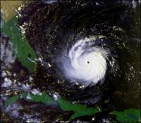
One very notable thing is Ida is still at maximum intensity, with zero signs of weakening, it might even be strengthening still! Check out rapid scan IR https://weather.cod.edu/satrad/?parms=meso-meso1-14-96-1-10-1&checked=map&colorbar=undefined
-
I'd say there's a 90% chance we're gonna have a major oil spill, from this and all the other oil facilities/rigs getting obliterated.
-
So even though the Jokko guy has said some incorrect things, he is positioned in outer eyewall right now, and in perfect spot to get hit with inner eyewall shortly, at which point he really could really see those 150+ mph winds. https://www.severestudios.com He's in a better position than any other chaser.
-
Underwater cam in Grand Isle is definitely back live https://www.severestudios.com/storm-chasers/john.humphress2.html
-
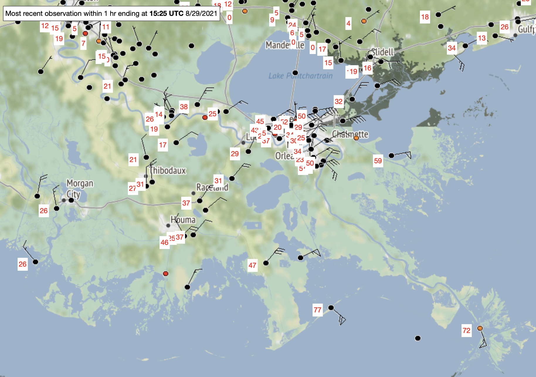
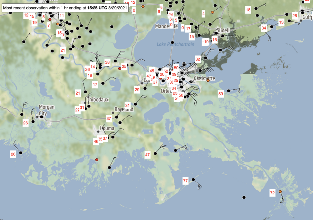
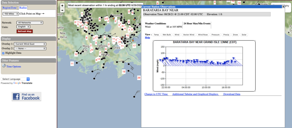
50-60 mph winds spreading through the New Orleans metro area, which is the level where winds start to become quite damaging. Hurricane force winds down in Grand Isle. It's amazing the camera is still running there.
-
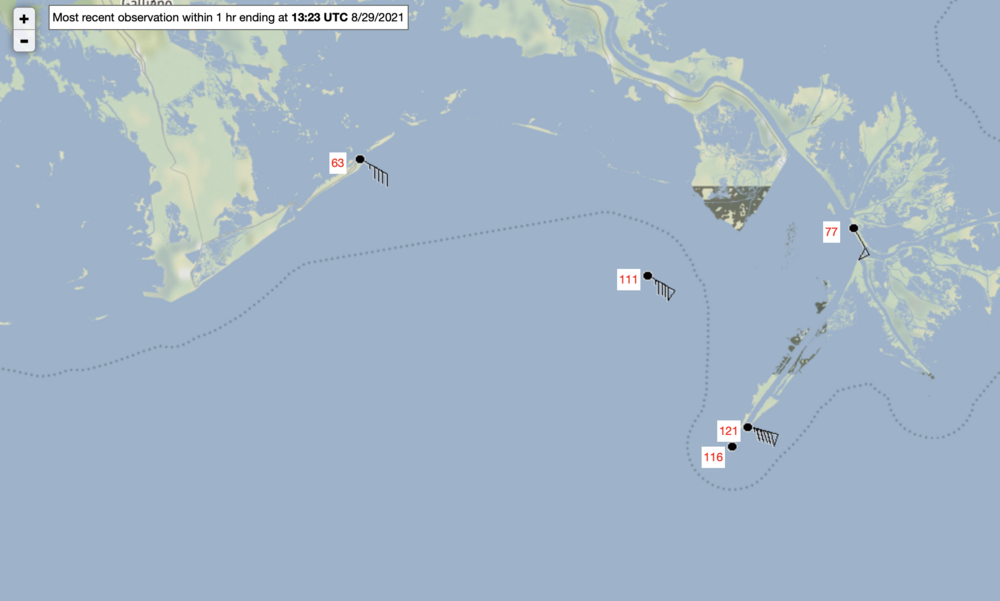
Wind gusts of 120+ mph (100+ sustained) on Mississippi Delta, these are observations that are technically on land. This is not even the eyewall!!! Just inner bands. This is extremely rare to see winds this high outside the eyewall.
-
Morning forecast update
-
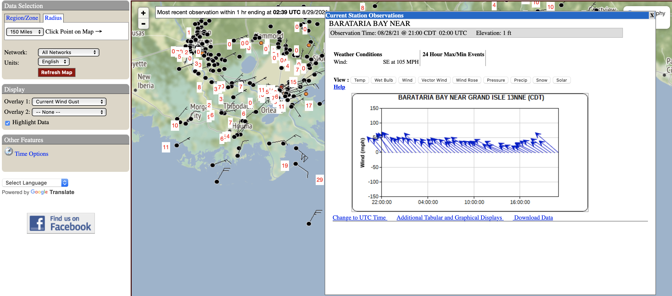
Buoy just off SE Louisiana gusting to 105 mph. Possible temporal anomaly? Did Ida get so strong that it is shredding apart space-time?!?
-
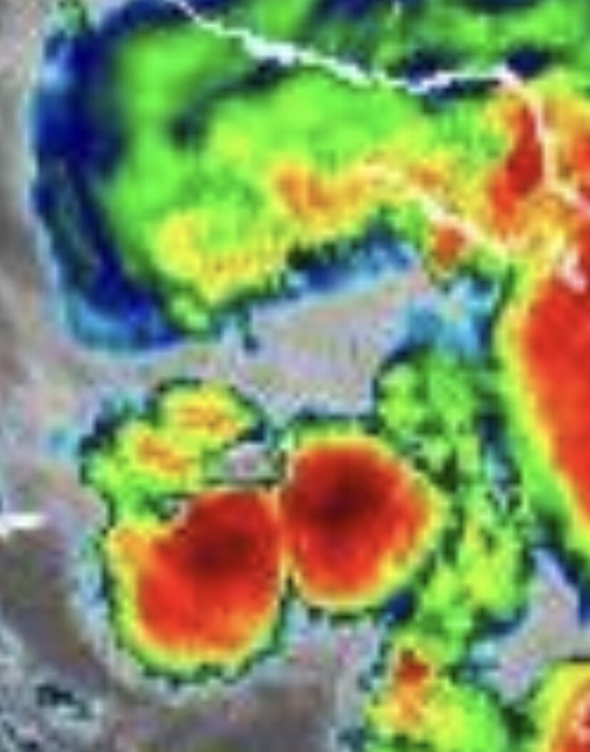
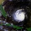
It is too bad recon is gone for awhile, eye going pinhole on the rapid-scan. I'm just gonna say it now: this is going to strengthen to a Cat 5 with winds of 160-180 mph tonight. Caveat is eye will collapse into an ERC at some point later, hopefully recon gets there before ERC.
-
IR presentation rapidly becoming more impressive, vigorous deep convection wrapping all the way around. Probably making a run to Cat 4 right now, recon or not. https://weather.cod.edu/satrad/?parms=meso-meso1-14-96-1-25-1&checked=map&colorbar=undefined
-
Notably, Key West gusted to 64 mph yesterday during Ida's closest approach. Here's a snippet from NWS Key West disco early this morning: "After an extremely active late afternoon/evening and overnight period, with fast-moving squalls producing numerous wind gusts over 35 knots and a few gusts over 50 knots, weather conditions are starting to quiet down across the Florida Keys and surrounding coastal waters" Gusts in excess of 60 mph being reported at the oil rigs offshore the Mississippi Delta, and first squall line has moved in across the Delta. The hurricane has begun!
-
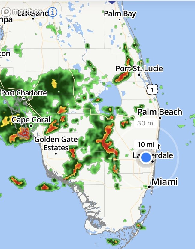
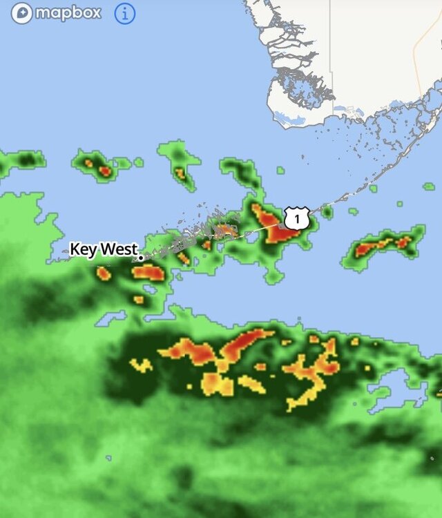
Ida’s outer bands have reached the Florida Keys
-
I’ve considered chasing this, but pretty sure my car would get destroyed, which is not worth it... I guess other chasers just get rental cars and trash them? I’m not willing to do that cause it’s against the Torah
-
this storm is finally growing some balls

-
The swamp animals are going nuts outside @Prospero it’s the ultimate cacophony. They know a hurricane is brewing near by. Also saw the full moon rising through outflow cirrus, it’s really cool
-
Thank you, I sensed there was some complex interaction going on between TD 9 and the disturbance that crossed Florida last night. Both systems flared up simultaneously, and they seemed to be attached from the beginning. I think the upper-low feature deepened more than expected, thanks to the plethora of deep convection it was producing, leading to a far weaker steering ridge. It seems Ida is coupling with the poleward current on the east side of the upper-low, indeed Ida's outflow is spreading north at incredible speeds, and has crossed the Florida Straits in just a few hours. I can actually see Ida's outflow cirrus from my balcony right now. This divergence will help Ida to quickly intensify, and convective development is biased towards northern semicircle too, both of which are factors that will push Ida north and east of track.