
turtlehurricane
-
Posts
5,005 -
Joined
-
Last visited
Content Type
Profiles
Blogs
Forums
American Weather
Media Demo
Store
Gallery
Everything posted by turtlehurricane
-
FLL has had peak gusts in excess of 45 MPH for 3 hours now. It's become a constant breeze and rain here, with embedded powerful bands. Another band just came through. Floodwaters are noticeably rising with each band. I imagine this is nothing compared to what it's gonna be like once Eta actually moves north of Cuba and into the Florida Straits, at that point it should get crazy with nothing between Eta's center and the Florida coast. Indeed, it is impressive we're getting such strong effects while it is still south of Cuba. Eta's convection is stronger than ever as it approaches the Cuban coastline. Upper level dynamics are really fueling its intensification and growth.
-
Having another powerful rainband now. Highest winds yet here, 40-50 mph. Avocados began raining down right in front of me, I dashed out to get them and got 4 big avocados in just a minute! EDIT: FLL gusting to 48 mph again, just like the last band
-
This rainband we just had easily had tropical storm conditions, torrential rain and lots of wind. In-fact, it is confirmed. KFLL gusted to 48 mph and a site on the coast gusted to 49 mph. Crazy were already getting tropical storm conditions, and it's gonna be deteriorating all the way through Monday morning.
-
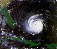
Just went outside and it is ominous. Lots of wind, and Mesowest showing wind gusts exceeding 30 mph here on the coastline. Radar shows a strong rainband is moving in. It's already flooded out there, the street I live on is literally a river at this point, since the grounds were saturated from lots of rain this past month, and we had alot of rain earlier today. The flooding threat here in Southeast Florida is extreme. NHC forecasting 10-15 inches, which would be totally insane on top of the already saturated grounds. Meanwhile Eta looking impressive as it approaches landfall in Cuba. There is a tremendous amount of upper level divergence that is fueling Eta. It's concerning what could happen once this gets over the Gulf Stream considering the upper level support. May not be a classic looking hurricane, but could end up with a 100 mph sub-tropical 'perfect storm'.
-
It was Shabbos, so I was not able to see any of the updates until now. The day started with underwhelming weather. NWS said flooding should've began last night, but instead when I awoke it was just cloudy with intermittent wind gusts. Then in the late morning we had 1 passing heavy downpour, and then another heavy downpour around 1 PM. I was beginning to question if anything was really gonna happen, since so many times this season storms have missed here. However, around 4 PM it began to pour, and the rain didn't stop for hours. The winds were some of the strongest we've seen this year as well, easily gusting over 40 MPH. Once I turned the computer on I see we are under a Tropical Storm Warning, with tropical storm conditions possible even tonight in rainbands, and indeed earlier we already has some Tropical Storm-esque conditions. It seems this is a huge storm, and it's already begun, so tons of flooding and wind is coming. Most interesting wild card is it will be over the Florida Straits for about 24 hours, and it's already approaching hurricane strength, so we could easily see some RI especially since a ridge will be building in, which is a highly favorable setup. NHC has appropriately issued a Hurricane Watch, since this could surprise everyone and go up to Cat 2-3.
-
I just noticed that since were past the time change that NHC advisories are coming out at 10 AM. I've never seen that before, cause there's never been a storm this late in the season that was a threat. NHC forecast track has Eta making landfall in the Keys and the southernmost Everglades Sunday night, but of course it will be a fairly large system, and tropical storm force winds will mostly be on the north side. Tropical storm watches may be raised as soon as 5 PM, or 10 PM at the latest, if trends continue. There is an increasing risk of impacts from wind and flash and urban flooding due to heavy rainfall in portions of southern Florida, the Florida Keys and portions of the Bahamas this weekend and early next week. Tropical Storm or Hurricane Watches will likely be issued later today or tonight for a portion of this area. The new forecast track requires a Tropical Storm Warning for the Cayman Islands at this time, and a Tropical Storm Watch for portions of Cuba. Watches may be required for portions of south Florida and the Florida Keys later today or tonight.
-
The rain threat has underperformed here overnight, but notably Southeast Florida has just been placed under a Flood Watch and a Wind Advisory. NWS thinks the flooding threat and gusty winds will really kick off tonight. The frontal boundary over South Florida along with Tropical Cyclone Eta forecast by NHC to move through the Florida Straits and Florida Keys this weekend will help to bring the very deep tropical moisture into South Florida from the Caribbean Sea. The grounds are also still somewhat saturated from the late October rains over the eastern areas of South Florida. Therefore, it will not take much to cause flooding over the region especially over the east coast metro areas. At this time, it looks like 5 to 10 inches are possible over the east coast metro areas tapering down to 2 to 5 inches for the west coast metro areas with locally higher amounts where showers and thunderstorms train through Tuesday. Therefore, a Flood Watch has been issued for the east coast metro areas from tonight through Tuesday evening. Models seem to be quite consistent over the last day about a Southeast Florida landfall of a strong tropical storm or even Cat 1 Hurricane. We will see, it's still up in the air and the track forecast is complex and uncertain, especially until we start getting real center fixes.
-
18z GFS takes Eta right through Southeast Florida. First model run in awhile which has shown a direct hit here. Hour 78... looks like a hurricane too. That would be crazy and awesome.
-
An extremely interesting period of weather has begun here. For days we were getting wind gusts of 30-40 mph associated with our first cold front of the year, a cold front which didn't even drop the low temps below 70, so it wasn't enough to cool the waters. Indeed, as I write this FLL is gusting to 37 mph. Now the front is lifting back north and the moisture is returning. It started yesterday with some brief showers coming in off the ocean. Overnight these showers turned into quick moving heavy downpours. Now the radar is really starting to light up, and the NWS says there's a flooding threat even today, and this is just the beginning, with the flood threat increasing overnight and into tomorrow. Basically, the rains associated with this system are already underway, and conditions will deteriorate until Eta makes its closest approach on Monday or so. It really is up in the air on what exactly will happen with ETA, and if any damaging winds will reach South Florida, but the rain threat is already a certainty.
-
I've been in the cone since the afternoon advisory, with a tropical storm projected to be in the Florida Straits on Sunday. I don't remember the last time I was in a cone in November. It is quite remarkable. Ultimately, this reminds me of Hurricane Mitch, which ended up coming across South Florida as a tropical storm. HWRF/HMON show a similar scenario with a tropical storm hitting South Florida, although the scenario is a bit different since it zig zags back into into the Gulf. Most notable thing is the tremendous rain that is possible. It's been a wet year here, and this would lead to extreme flooding. Hydrologic Outlook National Weather Service Miami FL 523 PM EST Tue Nov 3 2020 ...VERY HEAVY RAINFALL POSSIBLE THIS WEEKEND INTO EARLY NEXT WEEK ACROSS SOUTH FLORIDA... NHC is forecasting Tropical Cyclone Eta to move into Nicaragua and through Honduras tonight into Wednesday before moving back into the Northwest Caribbean Sea by end of this week. NHC is then forecasting the system to move into the Florida Straits this weekend. The long range models are showing a ridge of high pressure over the southeast United States to move east into the Atlantic waters, as a trough of low pressure develops over the Gulf of mexico and moves northeast into the Florida Peninsula. This will allow for deep tropical moisture to work into South Florida from the Caribbean Sea late this week into this weekend where the PWAT values in the 2.1 to 2.4 inch range which at the maximum value for the PWAT values fro this time of year leading to the possibility of heavy rainfall across the region. This means that showers and thunderstorms that do develop will be capable of producing very heavy rainfall this weekend. At this time it looks like forecasting at this time around 3 to 7 inches for the west coast metro areas to 7 to 15 inches for the east coast metro areas with isolated amounts up to 20 inches mainly between Friday early next week. Will continue to monitor the the forecast model runs on the potential of heavy rainfall for South Florida this weekend, and if trends continue then a Flood Watch may be needed late this week for this weekend.
-
This reminds me of Hurricane Mitch https://en.wikipedia.org/wiki/Hurricane_Mitch
-
Weather channel has live feeds out of New Orleans. https://livenewsof.com/the-weather-channel/
-
I'm pretty sure the levees in New Orleans will have a failure from this hurricane, since it is a major hurricane now. Just takes 1 little thing to go wrong, and the ocean will fill up the fish bowl. God forbid, of course.
-
Recon supports Cat 1, and it is very likely just a Cat 1, although NHC won't downgrade that far cause of continuity.
-

2020 Atlantic Hurricane Season
turtlehurricane replied to Windspeed's topic in Tropical Headquarters
This 'tropical disturbance', which is over South Florida now and the NHC says could form later this week as it heads north back towards us, is actually the first cold front of the year for South Florida. Cooler and drier air, and northeast winds of 20-35 mph. Most of all though, flooding rains as continental air slams into tropical air. Basically, once the cold front stalls over Cuba and the Keys, it will have plenty of time to brew. This is a harbinger for the beginning of West Caribbean season... -
2020 Atlantic Hurricane Season
turtlehurricane replied to Windspeed's topic in Tropical Headquarters
West Caribbean will be crazy going into October. Florida will be lucky to not see some serious threats with the way this season is going. -
2020 Atlantic Hurricane Season
turtlehurricane replied to Windspeed's topic in Tropical Headquarters
There's always hurricane action on Labor Day. I remember my dad grilling burgers in the outer bands of Hurricane Frances on Labor Day. This year doesn't look like anything will hit on Labor Day itself, but models suggesting that Cape Verde wave will be getting threatening around then. -
You are SO full of it. Whenever I've posted real science in here the response from you is a flurry of random graphs that are usually off topic. This entire place is a trollathon for anyone that doesn't believe in extreme AGW, so the discussion has become personal attacks all the time. When I first started posting here I was trolled and insulted relentlessly even though I was trying to be cordial, and now I'm basically doing the same. You guys win, you can roll around in your own stupid ideas without me bothering you.
-
dear lord lol
-
You wish there was death and destruction all over the world, we get it.
-
No, that is such an insignificant effect.
-
How arrogant of you, as if you're smarter than everyone else because they don't believe global warming is a big issue.
-
I suppose you're talking about the very long term trend where there's been a 3X increase since 1750. Things have stabilized relatively in recent decades though, as your graph shows. What I want to see is how even a 3-fold increase affects the atmosphere, and that doesn't mean it's likely to happen again anytime soon. A back of the envelope calculation is CH4 increased from 0.6 to 1.8 ppm, while CO2 increased from 280 to 380 ppm. CH4 is 25X more potent than CO2, so the CH4 increase is 30 ppm if it were "converted" to CO2. So the 3-fold CH4 increase accounts for ~25% of AGW so far, significant but not catastrophic, since AGW is probably about 1 °C so far. Basically, very extreme releases, well more than anything we've seen, will be needed to really cause some climate change.
-
Your chart is in nanomol/mol, the CH4 is ~1000 so it's in micromol/mol. The change in CH4 is on the order of about 10-100 nanomol/mol.
-
Note that the amounts are in nanomol/mol, there's not much CH4 to begin with, and it's only increased slightly relative to the total amount of CH4.


