BullCityWx
-
Posts
8,924 -
Joined
-
Last visited
Content Type
Profiles
Blogs
Forums
American Weather
Media Demo
Store
Gallery
Everything posted by BullCityWx
-
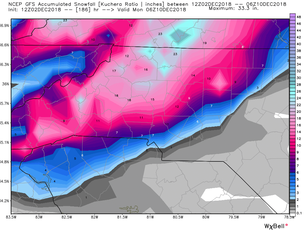
Actually it's a 20" snowstorm from greenville up to almost charlotte.
-
12z Euro. 24" at Spartanburg at 192.
-
Wow, there's some 20" totals across the northern upstate on the kuchera maps.
-
SOLD.
-
Someone gets a tree snapping storm somewhere between Cola and Raleigh on that run. Ouch.
-
FWIW 12z GEFS has a mean snowfall at Chapel Hill of 4". For those of us in the western areas of the triangle, I still like this event.
-
FV3 took freezing rain down to Atlanta.
-
That is a kuchera map so it took out sleet and zr.
-
I'm not sure of the accuracy of the norwegian or aussie models on weather.us but they give me all snow so I like it.
-
I mean as depicted, if you're S&E of say Durham, it would be a tough run. Wxbell maps still show Chapel Hill at 4" this run and up over half a foot north of 85 in Durham County.
-
I dont know, I kinda like where Sean and I sit in NW Durham.
-
Almost 24 hours for it to get from Anderson, SC to the NC/VA border.
-

Southeast Sanitarium - A Place to Vent
BullCityWx replied to Jonathan's topic in Southeastern States
I'm sitting here trying to figure out how places like Carolina Beach and Orangeburg are suddenly CAD storm territory. It's a close enough shave up here. -
Southeast Sanitarium - A Place to Vent
BullCityWx replied to Jonathan's topic in Southeastern States
Looks like everybody forgot about Climo since last year. -
As much as I hate to say this, as I’ve lived and gone to school in Columbia, this storm isn’t going to do much for areas south of a line from Clemson to Rock Hill. Now, that could change and we’re way out but it would take seismic changes for anywhere in the midlands to see more than a very slight glaze.
-
You're right. People are acting like we've got this thing in the boat and I dont get itn frankly, I've lost dozens of storms in this time frame over the years.
-
FWIW, the 6z GEFS cut the mean snowfall in half for many locations.
-
Southeast Sanitarium - A Place to Vent
BullCityWx replied to Jonathan's topic in Southeastern States
It has happened two or three times since the 1870s. You can’t be mad at climo. -
That is just west enough that is probably the worst case scenario for Raleigh east, maybe even Durham.
-
She's not going to be able to turn quickly or sharply if she strengthens too much.
-
Yeah. I think the winds would actually not be as big of an issue because she's just so slow. People forget that Hugo made it to Charlotte six hours after landfall.
-
As someone who lived through Hugo, I swear I don’t know what he’s seeing. You’re right though, every storm is it’s own storm.
-
The HMON corrected about 200 miles west and had her inland over Horry County
-
Funny this is the 100 year anniversary of the 1918 flood.