Radtechwxman
-
Posts
2,481 -
Joined
-
Last visited
Content Type
Profiles
Blogs
Forums
American Weather
Media Demo
Store
Gallery
Everything posted by Radtechwxman
-
Going to be a nail biter here in Peoria. 1st wave on most guidance minus UKMET/GEM misses me largely north and 2nd wave has the low nearly on me on most guidance. I'm expecting more ice than anything now and some plain rain. Unsure on snow potential.
-
Man if only I could lock in that run of Canadian. Great front end thump and decent 2nd hit from the secondary low
-
That would be a very 2020 track and perfect scenario to end this whack year
-
Watch this secondary low follow the same path the Christmas Eve/Christmas day storm followed. That ridging to the east will be critical in determining if this is more of a GL cutter or an App runner. Definitely will be interesting to see what evolves as this trough is impressive.
-
I'm honestly surprised how east the secondary low goes with how the upper levels look. You would think this could trend west given how wrapped up it gets
-
Nice to see euro on board with robust secondary low development. But I'm feeling that the first wave will miss me to west with snow and second wave east. Sounds about right. Obviously it's early and track is far from locked in but that's typical luck for my area. Lol
-
Euro definitely took a big step towards GEM but like hawkeye stated, it wraps it up later and the front end hit isn't as aggressive as GEM. Chicago area could luck out on this one esp with secondary low development.
-
If only the Canadian model could be right for once eh
-
I see 12z gfs looks a lot like euro now with a way west cutter. Joy. The year going out with the 2020 trend....CRAP. Hoping we can trend back to at least a decent front end thump but I'm not holding my breath.
-

Winter 2020-21 Medium/Long Range Discussion
Radtechwxman replied to Hoosier's topic in Lakes/Ohio Valley
THIS. Lol. I like the active pattern with powerhouse storms but definitely would like to see the storm track shunted more south and east. Cold rain is no beuno -
0z model suite so far is about as encouraging as this year has been. Never was expecting much from this but was keeping a glimmer of hope because of euro. But everything is slowly caving to GFS. At least the pattern looks somewhat active after this wannabe storm.
-
Euro definitely caved from a sfc perspective towards GFS. Honestly think we will see a lot of flip flopping this week until the energy gets better sampled. Nam has a more euro look but it's also Nam at 84hrs. I'm not getting my hopes up for any snow at this point.
-
Who will cave first? GFS or Euro
-
Dec 16-17 Storm OBS Thread
Radtechwxman replied to BuffaloWeather's topic in Upstate New York/Pennsylvania
All hail thundersnow!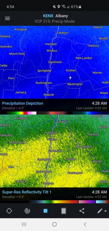
-
Dec 16-17 Storm OBS Thread
Radtechwxman replied to BuffaloWeather's topic in Upstate New York/Pennsylvania
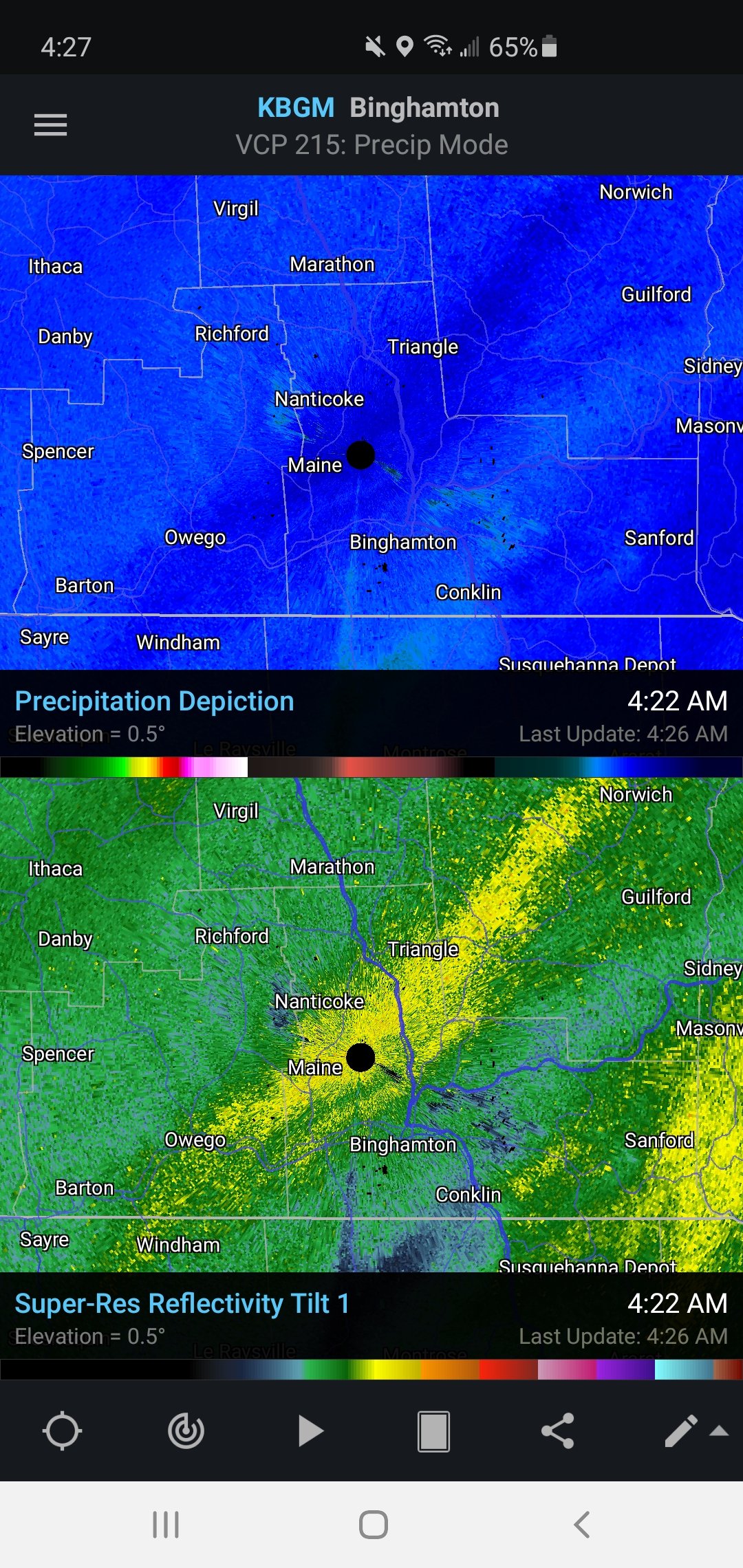
Good grief. Here we go again. Another impressive band setting up near Binghamton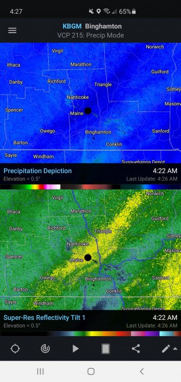
-
Dec 16-17 Storm OBS Thread
Radtechwxman replied to BuffaloWeather's topic in Upstate New York/Pennsylvania
You're thoroughly entrenched in that band now like Binghamton was earlier. Will probably be in it a while -
Dec 16-17 Storm OBS Thread
Radtechwxman replied to BuffaloWeather's topic in Upstate New York/Pennsylvania
Only negative to experiencing something this high end is that next snowstorm when you only get 1-2in/hr rates or less you will be like meh. Be like man I only got 12in in 12hrs instead of 2-3 hrs. Super lame. Lol -
Dec 16-17 Storm OBS Thread
Radtechwxman replied to BuffaloWeather's topic in Upstate New York/Pennsylvania
Lightened to 2-3in/hr? Lol -
Dec 16-17 Storm OBS Thread
Radtechwxman replied to BuffaloWeather's topic in Upstate New York/Pennsylvania
LOL. You have got that in the last 3hrs probably. This is WAY overachieving. No model pegged something this crazy evolving. -
Dec 16-17 Storm OBS Thread
Radtechwxman replied to BuffaloWeather's topic in Upstate New York/Pennsylvania
What your experiencing is on caliber with some of the most intense lake effect bands. Truly historical synoptic snowstorm tonight. -
Dec 16-17 Storm OBS Thread
Radtechwxman replied to BuffaloWeather's topic in Upstate New York/Pennsylvania
The more intense portion of this band seems to be refocusing now by Oneonta and just northwest. So instead of 5-6in/hr near Binghamton it may only be 2-3in/hr now. Lol. I'm shocked a band this intense and with so much frontogenic forcing hasn't produced some thundersnow. Could be because the sfc temps are very cold. Probably would be more likely if temps were in upper 20s or low 30s. -
Dec 16-17 Storm OBS Thread
Radtechwxman replied to BuffaloWeather's topic in Upstate New York/Pennsylvania
That has to be a record. Very rare you get this kind of qpf in air this cold. Probably one of if not the most incredible synoptic mesoscale bands I ever seen. Rare you get snowfall rates like this in general esp outside of LES bands. Snow ratios are probably ridiculous right now. -
Overall CDO seems to have warmed some but man that lightning in the southern to southwest eyewall has been relentless. Not sure this will hit cat 5 before landfall though.
-
More turbulence. Changing wind directions
-
Still not finding any higher FL winds than 137 knots?